Tullahan,
a small coastal village between Bundoran and Cliffoney, has at least six megalithic
monuments closeby. Tullahan is located in County Leitrim, where a 3 km stretch
of coastline bounded by the rivers Duff and Drowse seperates County Sligo from Donegal. Two megaliths are at located at Magheracar, just north of the river Drowse in County Donegal, and at least five at Wardhouse in Co Leitrim 2 km to the west.
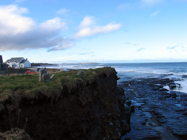
At Magheracar the remains of a circular
kerbed cairn with a straight or undifferentiated passage, sits on the
cliff behind the village overlooking Donegal Bay. This site is classifed as a passage grave, an outlier of the small complex buried under the sandhills at Finner a short distance up the coast. A good half of the
monument has fallen away into the sea due to erosion, and recent storms have further undermined the remains.
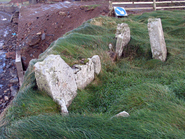
The Magheracar chamber in 2014, during a lull in the series of storms that thrashed the west coast of Ireland.
This is
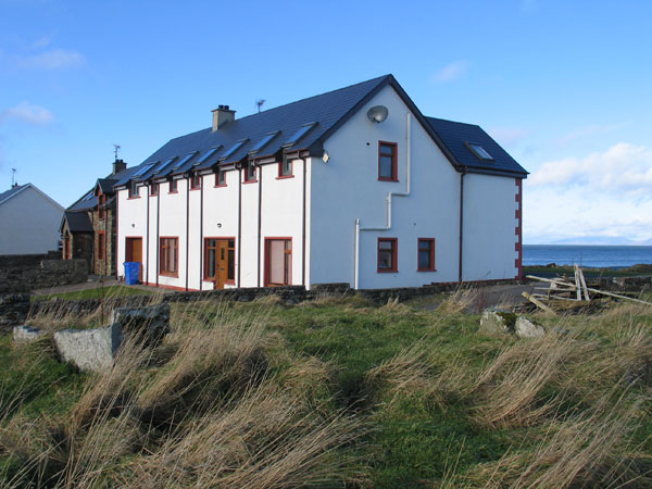
an area that has suffered badly under the Celtic Tiger era. Closeby are seven or eight slabs, the remains of a wedge cairn. The property
around these ancient megaliths has all been developed, and now the monuments
are surrounded by an estate of ugly and often unfinished houses. The area is popular with surfers with great waves crashing onto the shore here. It is hard to believe that monuments which were once so well known have come to such an end.
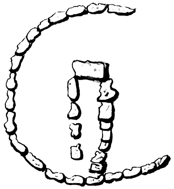
The illustration of the circle and chamber by William Jones for Edward Lhuyd, 1700.
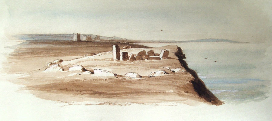
These monuments were visited by the Welsh antiquarian Edward Lhuyd in 1699 on his tour of Ireland. He probably visited Tullaghan House, which is shown along with what looks like Bundrowse castle (which was not standing during Wakeman's time) in Wakeman's 1880 drawing, top of page. Lhuyd left a drawing of the monument, by his draftsman William Jones, showing the circle or boulder kerb two-thirds complete. It is interesting to note that this is one of the earliest illustrations of a megalithic monument we have. Lhuyd visited the stone circles at Cong and was one of the first people to enter the newly opened Newgrange on the same journey.
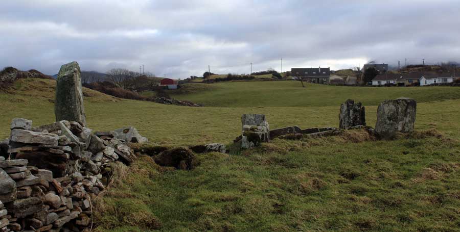
The Magheracar monument in 2010, as house building projects grind to a halt.
Magheracar is mentioned in Wood-Martin's Rude Stone Monuments from 1895 where he says 'Many years ago bones, ashes and a cinerary urn were found in this tomb'.
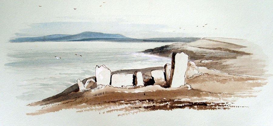
The ruined megalithic chamber at the cliff behind Tullahan village, illustrated by
William Wakeman on his tour of ancient sites in Connaught in 1880. Image copyright Sligo Co Library.
Archaeological Report
The monument was investigated by OPW archaeologist Eamon Cody in 1986 and 1987, and his archaeological report has just been published in 2019.
'The monument, an undifferentiated passage tomb in a semi-circular kerbed mound, is at the edge of a sea-cliff, 5m high. The kerbed mound, 20m in diameter E-W, was assuredly originally circular, its northern half now lost to the sea. The tomb, facing SE, is 4.5m long and scarcely more than 1m wide, and stands 2.5m inside the eastern edge of the kerb. Prior to excavation, its N side and back survived intact, but only two stones (one broken) of its south side. Within the tomb, 0.5m from the front, a sill-stone was visible.
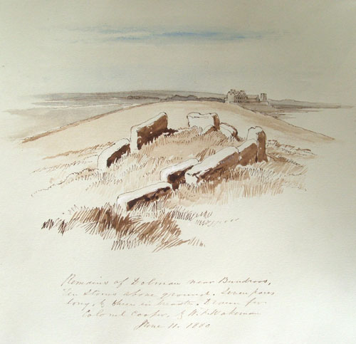
Wakeman's illustration of the chamber in 1880. Today it is on a small
plot of land between a house and a derelect building site.
Because of its proximity to the cliff edge, about 0.2m at one point, the tomb is under threat and so an excavation, at the request of, and funded by, the National Monuments Branch of the Office of Public Works, was undertaken at the site over a five week period during September and October 1986.The excavation was largely confined to an area 4m wide extending eastwards from the back of the chamber to and beyond the kerb.
The grass-grown mound, which extends for some 5m outside the kerb, is made up of earth and stones, some quite sizeable. A large kerbstone directly in line with the tomb is positioned slightly inside the circumference described by its fellows, and at either side, as if to highlight it, are two smaller stones. The kerbstones are rounded or oval in shape, the latter type set with a long side on the ground, and, where necessary to prevent toppling, supported by small rounded beach stones.
The same view in 2014.
Almost the entire tomb area was excavated, revealing, in addition to the sill-stone visible before excavation, two others between it and the back of the tomb, while across the front of the tomb two stones set side by side formed a double sill. The sills divide the tomb into four compartments, from the front approximately 0.5m, 1m, 1m and 1.8m in length. A large stone with smaller stones alongside served as a floor covering in the second compartment from the front. Between the kerb and the front of the tomb, stones had been laid flat on the ground to form what appears to be a pavement.
A considerable quantity of fragmented bones, some pieces with charcoal attached, was found in the tomb. The bones were dispersed throughout the earthen fill and extended under the bases of the sills and in the case of the two inner compartments to the level of the uneven underlying rock. Objects found include a small number of flint scrapers, some pieces of chert, some small sherds of prehistoric pottery, three fragments of a single stone bead found close together, a broken length of bone bearing concentric semicircular scores, a possible decorated pin, and a miniature stone axe-head, 5cm long.'
A second and final season's excavation was undertaken at this site over a six-week period during September-October 1987. The work was carried out at the request of the National Monuments Branch of the O.P.W. who also funded it. The monument is an undifferentiated passage tomb standing towards the eastern side of a kerbed cairn sited on a sea-cliff. The cairn measures 20m east-west but only 10m north-south as its northern half has been lost to the sea. Three cuttings were made in the cairn and, in addition, excavation of the tomb area (the focus of the 1986 season's work see Excavations 1987) was completed.
A cutting, 19m long, was made from the back of the tomb to the west along the cliff edge and was continued for 8m beyond the kerb. The other two cuttings, parallel to each other and 4m apart, both 2m wide, ran approximately north-south. The more westerly of these was 10m long and extended inwards for 4m and outwards for 6m from the kerb, while the other, 12m long, extended inwards for 4m and outwards for 7m. Both of these cuttings crossed a grass-grown trackway that runs east-west just outside the kerb at the south side of the cairn. This trackway had been formed by a levelling of the extra-revetment material.
At the west and south sides of the cairn two kerb-stones and parts of two others were exposed. These form part of a contiguously laid setting of large blocks of local stone. The cairn body, under a sod cover some 0.15m thick, is of stones and intermixed loose brown earth to a depth of some 0.5m. The stones in its upper 0. lm are small and do not exceed Olin in maximum dimension while below them there are large slabs as much as 1J.8m across and 0.2m thick along with occasional water-rolled boulders. Under the cairn there is a compact layer, on average 50mm thick, of sticky earth, brown to blue-grey in colour, with small stones. This layer contained flecks of charcoal and occasional fire-reddened stones, reflecting pre-cairn activity. Finds made were confined to this layer and consist largely of waste flakes of flint and other stone. One of the few recognisable types is a leaf-shaped flint arrowhead, 30mm long.
Eamon Cody, Ordnance Survey, Dublin.
The gallery or chamber of one of the ruined court cairns at the Wardhouse megalithic complex, a few kilometers west of Magheracar.
Bundrowse castle
As a safeguard against the frequent incursions of O'Donnell
into Carbury, the erection of a castle was commenced in 1420 by
O'Conor, on the banks of the Bundrowse, at this time apparently
the extreme northern limit of his territory. O'Donnell's forces
assembled to prevent the work; O'Conor called out his levies to
protect the workmen, and he was joined by the O'Rorkes and
MacDonoughs. The northern army lay encamped on the banks
of the Urscatha, which was the ancient name of the stream that
falls into the sea at the little town of Bundoran.
O'Conor dispatched some cavalry to reconnoitre, and they encountered a
similar scouting party sent forward by O'Donnell, on the celebrated plain of Magh-g-Cedne, so often mentioned; it is now
always called, locally, " the Moy." The Carbury horse were put
to flight, and John, son of O'Conor, MacDonough, two of the
O'Dowds, with many other chiefs of lesser note, were killed.
On receiving intelligence of this disaster, O'Conor marched to
the scene of the skirmish, where he encamped, and five days
after, learning that O'Donnell, with his horse, was stationed at
Port-na-long (the port of the ships), on the northern side of the
cataract of Assaroe, and that great drinking and carousing were
going on in his lines, in celebration of the defeat of the men of
Carbury, O'Conor seized on the advantage presented by this
negligence on the part of his adversaries, and ordered Owen
O'Conor to cross the river, by a ford near Ballyshannon, with
the entire body of horse, and to make a night attack on O'Donnell, which proved entirely successful.
Donal O'Donnell, heir
to the chieftaincy of Tirconnell, was slain; O'Donnell himself
was forced to fly to tha seashore, and only effected his escape by
plunging into the tide, and swimming to an English merchantship which, fortunately for him, happened to be riding at anchor
in the harbour. After the victory O'Conor disbanded his forces,
and returned to Sligo, where he was met by Donal O'Neill, who
had been expelled from Ulster by his rival Owen O'Neill, aided
by the O'Donnells.
1422 - With these powerful
levies he advanced into Carbury, passed the Bundrowse river,
under the battlements of the castle, after a slight skirmish, and
pillaged the country to the walls of Sligo.
In 1499, Donogh-na-nordog O'Donnell, who two years previously had been taken prisoner by MacDermot at the battle of
the Curlews, but afterwards released, at this period captured the
castle of Bundrowse from his own father, O'Donnell, who, aided
by Maguire, at once proceeded to besiege it. A personal en-
counter ensued under the walls, between Maguire and Donagh-
na-nordog, in which "they pummelled each other;" but
Maguire having killed the horse of his adversary, succeeded in
making him prisoner. The castle then capitulated, and O'Donnell presented Maguire with sixty milch cows, as reward for his
skill and valour, and persuaded him to convey his son, Donagh-
na-nordog, to Brefney, to be there detained in confinement.
These three, along with Ó Cléirigh, were called the ‘Four Masters’ by Colgan in his preface to Acta Sanctorum Hiberniae, in recognition of the fact that they undertook the great bulk of the work leading to the Annals of the Four Masters. In undertaking the Annals Ó Cléirigh was greatly extending his original brief. They began work at Bundrowse in January 1632 and finished on 10 August 1636.
The Connaught contingent,
under the command of General Sarsfield, pitched their camp at
Bundrowse, waiting their opportunity to seize Ballyshannon.
MacClancy’s second stronghold at Duncarbry is mentioned in the Annals in 1537. This castle stood on a hill behind the site of Duncarbery Lodge. The date of construction is unknown, but McPartlan’s survey of Leitrim of 1802 records Duncarbery Castle as being “within a quarter of a mile of the sea; there is only one arch, over which is a gable remaining; it seems to have been of some extent and was built by Lady Isobel Clancy in the reign of Elizabeth”. Elizabeth I succeeded to the throne in 1558, but the castle must have been built before this date, for the Annals record the death of Cahir MacClancy in Duncarbery in 1537.
The mound on which the castle was built was the site of the ancient fort of Carbury (Dún Cairbre), from which the castle took its name. Brian O’Connor, despite the efforts of the O’Donnells, extended his territory to include Edergowen in 1420 and erected a castle at Bundrowes, digging a channel to divert the Drowes around it. The Duff, the Drowes and the Erne were, at different times, the southern boundaries of the O’Donnell territory. Edergowen had more than its share of O’Donnell and O’Connor armies marching across it until the 17th century, and the MacClancy writ seldom ran there. It wasn’t until the sixteenth century that MacClancys were sure enough of their hold on the area to erect Duncarbery Castle.
The O’Connors and Bundrowes Castle
The year 1420 was a turbulent one in Dartry. In order to consolidate his position, Brian O’Connor began to build a castle at Bundrowes. This action was resisted by the O’Donnells, who assembled an army to stop the building work. O’Connor gathered an army of his own, and the scene was set for another clash between the two clans. The O’Donnells camped by the Bay of Assaroe at Ballyshannon.
Some of the O’Donnell cavalry, led by O’Donnell’s sons Niall Garbh, Donnell and Naughten, set out to reconnoitre The Moy. At the same time the sons of O’Connor led another troop of cavalry towards Ballyshannon. The two cavalry troops came face to face; the O’Donnells charged and routed the O’Connors, killing John, son of Brian O’Connor. Despite this terrible setback Brian O’Connor advanced with his troops to Magh-Ene (Bundoran parish) and, five nights later, a large force of O’Connors crossed the ford at Ballyshannon. They surprised the O’Donnells, who had been drinking wine, and routed the unprepared Donegal men. Niall O’Donnell managed to escape by swimming to a ship in the harbour.
Having safeguarded his castle at Bundrowes, Brian O’Connor returned home.
That same year inter-family feuding again wracked the MacClancys. Cathal MacClancy, chief of Dartry and son of Teige, was killed “in his own house” (probably Rosclogher Castle) by his kinsmen Teige, Maurice and Henry. Hugh Boy MacClancy was also killed.
1421 again brought conflict into Dartry. War broke out between the O’Donnells and the O’Connors. The O’Donnells were joined by the O’Rourkes, and the allies destroyed much of the O’Connor territory. The O’Donnells and O’Rourkes then camped at Ballyshannon. The O’Connors, taking advantage of the absence of the O’Rourke army, attacked and destroyed the O’Rourke stronghold at Dromahair, burning the town around it and destroying the countryside. The O’Connors advanced to the castle of Bundrowes and the O’Donnell / O’Rourke alliance camped at Ardfarna. Daily engagements between the two sides resulted in the deaths of many men and horses. Eventually a peace was concluded between the warring factions.
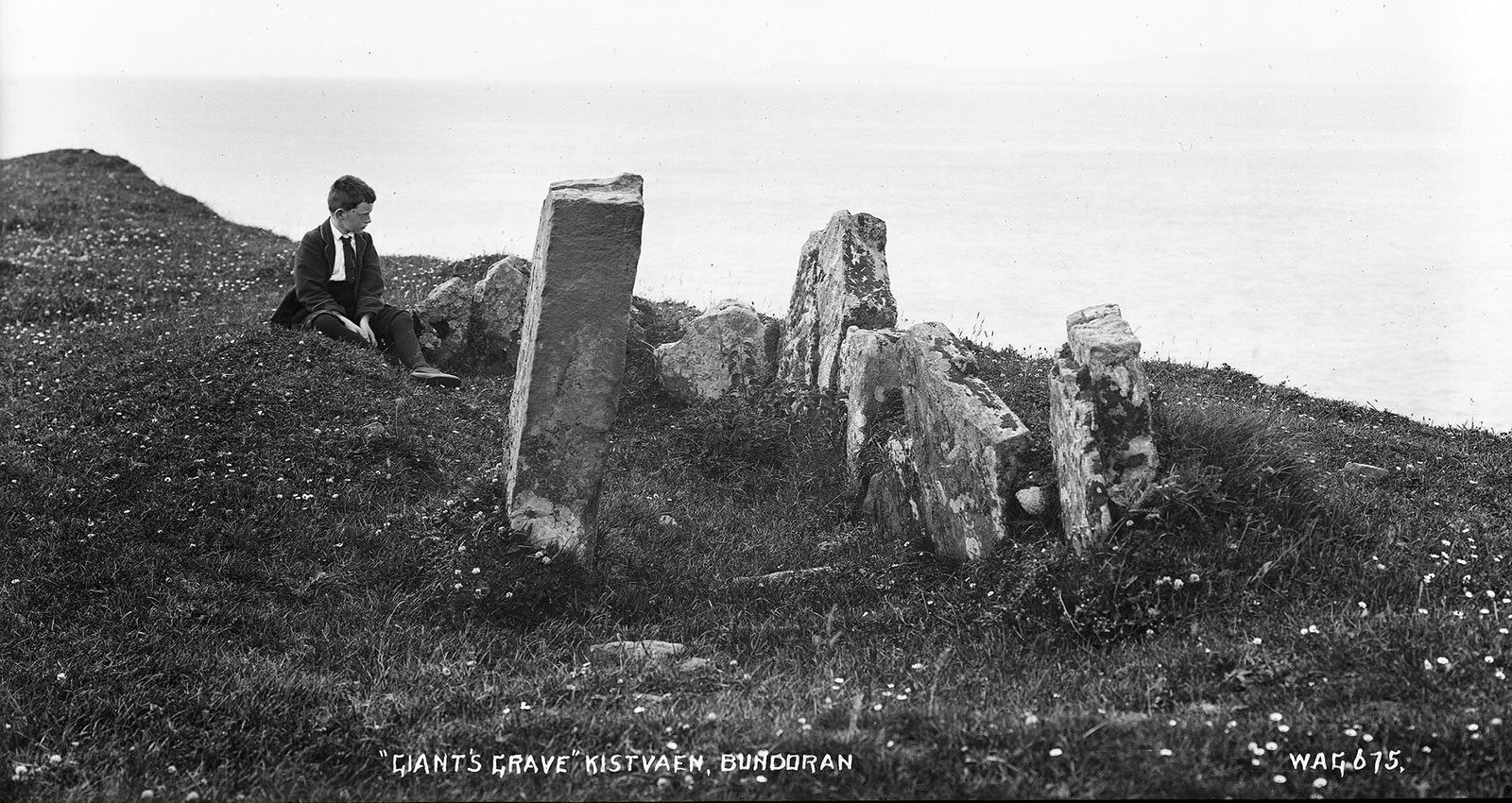
Giant's Grave at Bundrowse near Bundoran. 11 stones in chamber. No 1 view. Drawn for Colonel Cooper by W F Wakeman, August 1880.