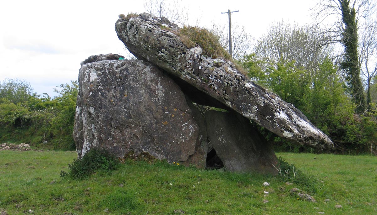
The Dromanone dolmen, also known as the Tinnacara portal dolmen is located 300 meters forth of the Boyle river in County Roscommon.
The Dromanone dolmen.
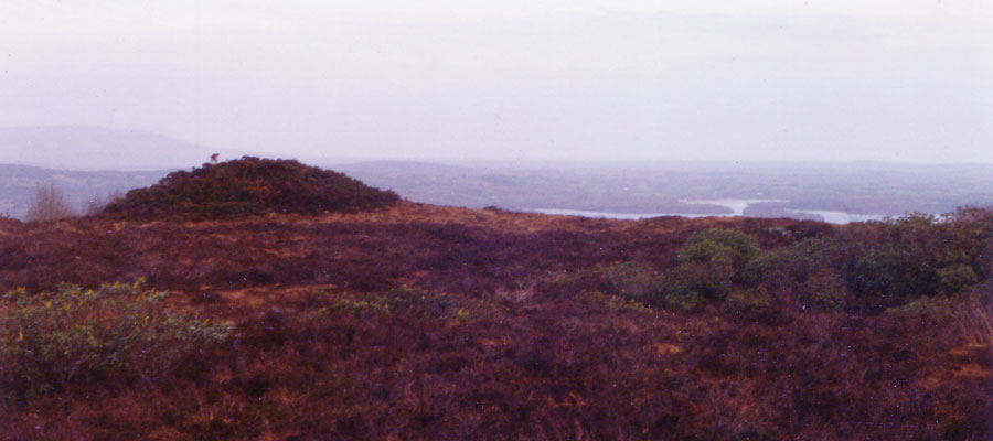
This fine portal dolmen is located just north of the Sligo-Dublin railway line about three kilometers west of the town of Boyle, and can be seen from the train as you travel between Sligo and Boyle. The monument stands close to the boundary of two townlands, Tinnacarra and Dromanone, and is known by a number of different names.
There is a Druids' altar about a mile to the east of this school. It consists of two upright stones, one smaller than the other and a big slanting flag on the top of them. The Druids used to offer up sacrifices there. They used to burn their offerings. The Druids lived beyond the lake in Lissadrea. The townlands in which the altar is situated is called Tinnecarra the rock of the fire. It has taken its name from the altar. There are upright and horizontal lines in the stones.
The Schools’ Collection: Tighmhanach, Co. Roscommon. Source
.
Directions: Tinacarra / Dromanone is an easy monument to find, and well worth a visit. Take the Gurteen road from Boyle;
park at the cottage on the right, just past a bad bend where the railway track crosses the road on an arched bridge. Walk about 200 meters up the
track by the cottage, and cross the track - carefully! - the dolmen is just inside the field by the track.
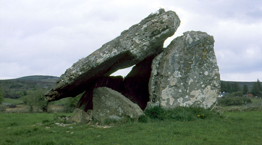
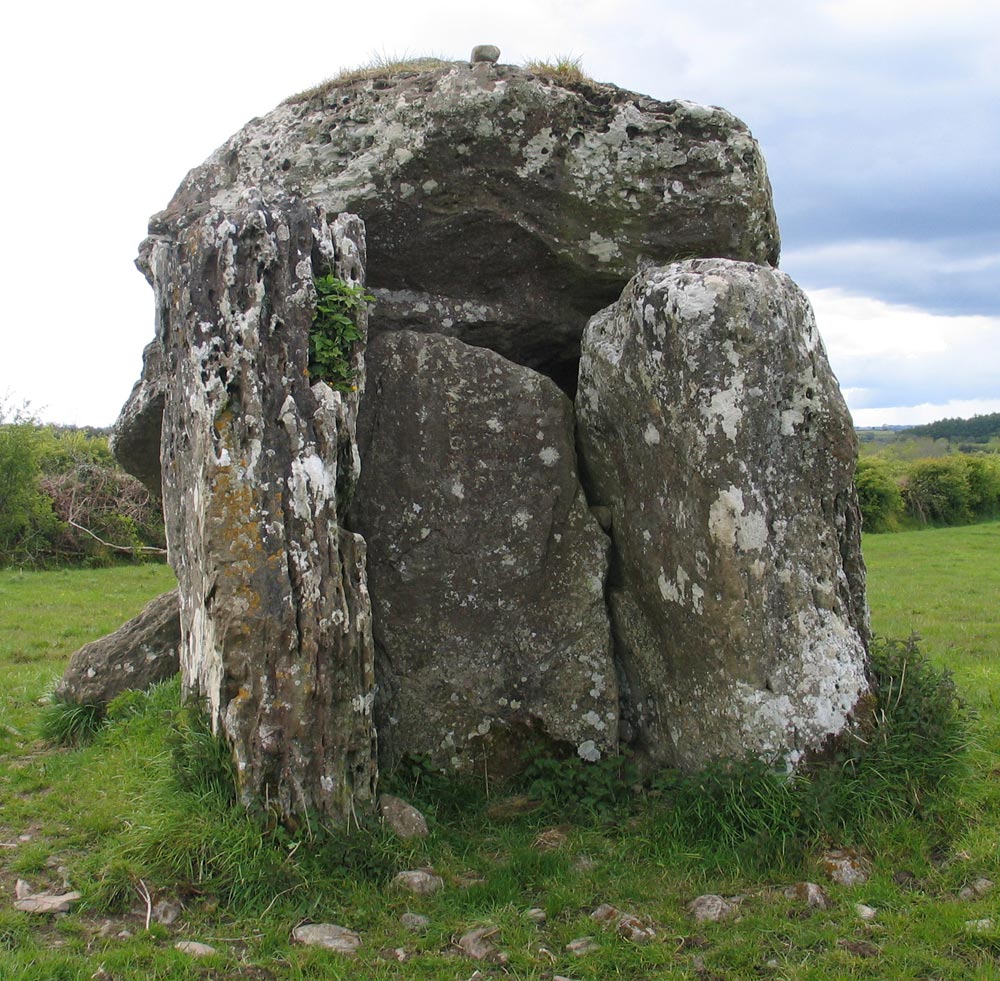
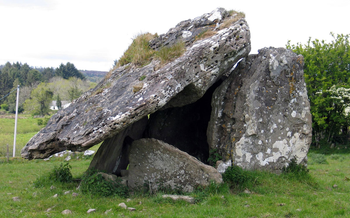
The stones are massive slabs of sandstone, with an enormous sloping capstone, four meters long, three meters wide and 0.75 meters in thickness. The tall and imposing portals are oriented to the hill of Sheegorey (The Fairy Mound of the Sandhill), where a cairn dating from the Neolithic or at least the Bronze age, on the most easterly peak of the Curlew Mountains (see picture below). An iron
strut was placed in the chamber within the dolmen to keep a leaning orthostat in position. The capstone is massive, and is tilted quite steeply. All structural stones are of local sandstone. These types of monument were surrounded by low cairns of stone, from which the capstone would have protuded, and the remains of a small cairn are visible here. The name Tinnacarra
means Stone of Fire. The site was excavated in 1954, and a fine polished stone axe was found here.
At a short distance to the north of this mill, on the right hand side of the road going towards the lake, and not far off it, stands one the largest cromlechs that I have seen in Ireland. The sloping upper stone is fifteen feet long by eleven broad; its greatest thickness two feet six inches, and its average thickness might perhaps be safely set down at eighteen inches. It is now supported by four upright stones, but, once, had a fifth.
The tall portal stones and the blocking stone at the Dromadone dolmen.
To this, the neighbouring miller, in an evil hour, took a fancy, judging it would make an admirable stone for his mill; and with much difficulty and labour he removed it from its place; but just as the operation was on the point of being completed, the stone, to the amazement and terror of the bystanders, flew into a thousand pieces; an occurence which was interpreted as a judgement upon the miller for his audacious violation of this sacred work of antiquity. The people still look upon the cromlechs with a degree of respect, if not veneration, althought they have no notion of their origin, or of the purposes to which they were destined.
Just 100 meters to the south of the dolmen, a standing stone of local sandstone stood until 1965, when it was removed and placed in the ditch close by. While it is tempting to imagine the stone and dolmen may be contemporary, such pillar stones usually date to the Bronze age. There is a fine example of a bronze age barrow, Knockadoobrosna, beside
the Boyle golf course, a few kilometers to the south. Another huge barrow, or
possibly even a neolithic mound, sits atop the hill known as Carnlewey south
east of Boyle. There are many barrows dating from the Bronze age scattered across the Plains of Boyle.
The impressive Dromadone portal dolmen was excavated by C. Topp in 1954.
Excavation Report, 1954
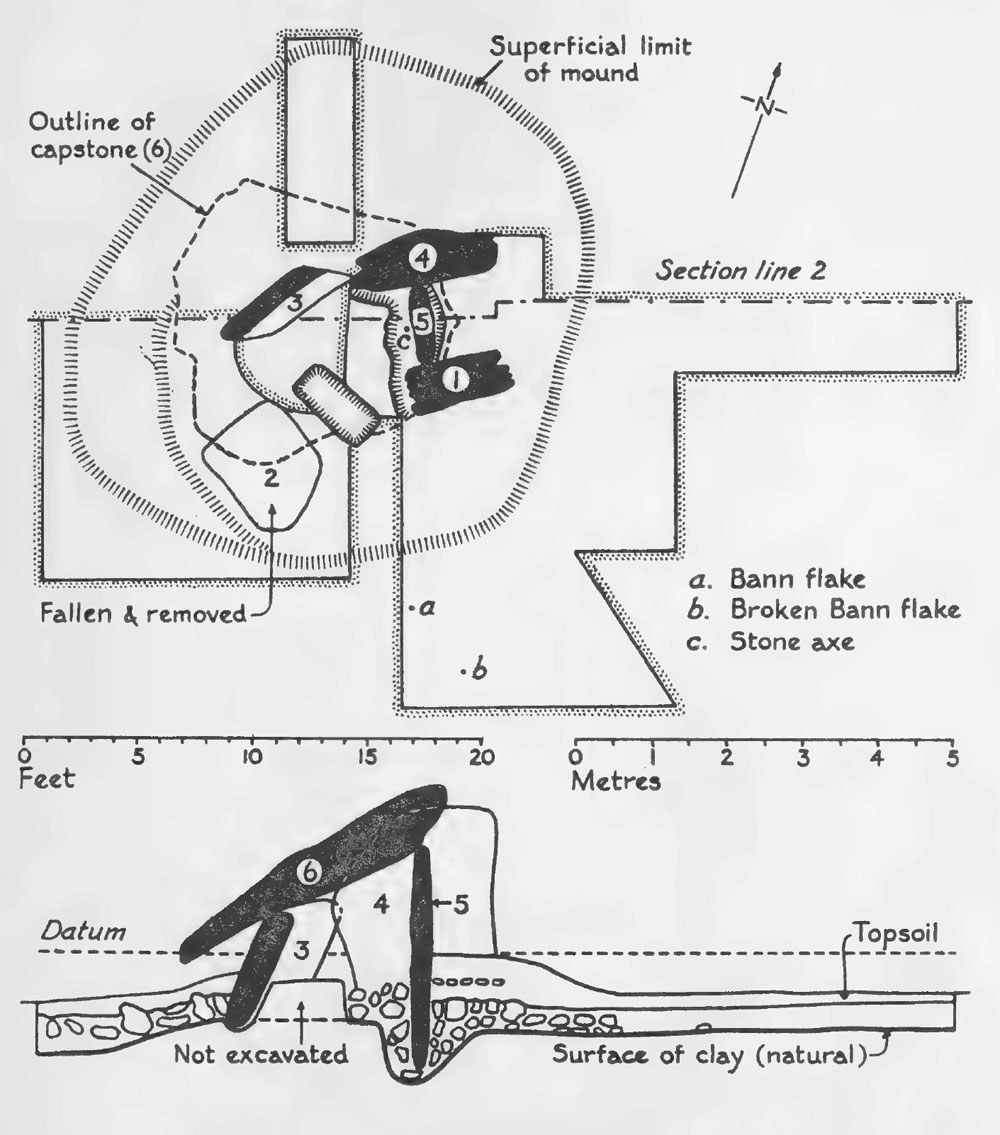
The monument which is the subject of the present paper is situated in the Townland of Dromanone, parish and barony of Boyle, Co. Roscommon. It lies 200 yards north of the Boyle River’s emergence from Lough Gara. Although slightly below the 300 ft. contour it occupies a dominating position in the countryside. Geologically the area is one of Lower Carboniferous Sandstone which is almost everywhere drift-covered. The dolmen itself is built of millstone grits whose massive coarse quartzose sandstone contains much mica. These blocks may well have been brought from the Curlew Hills though there is always the possibility of the presence of erratics on the site.
Former References: - The dolmen is mentioned in Borlase who reproduces a sketch taken from Wilkinson’s Ancient Architecture of Ireland and quotes Grose’s description of it in the Irish Penny Magazine of September 7th 1833. It was also described and measured by the Rev. F. E. Clarke who specifically states that the capstone does not rest on ‘the eastern transverse’ (i.e. the portal stone No. 5 on plan, Fig. 1). He also quotes Weld’s story of the eighteenth century miller who removed one of the uprights and thus caused the present marked slope of the capstone.
The plan and elevation of theDromadone dolmen from the 1954 excavation.
The chamber consists of a capstone 4.3 meters east to west by 3.6 meters, with a maximum thickness of 0.7 meters It rests at present on the two northern orthostats and on the portal stone. It has obviously slipped sideways and back- wards and-is now tilted at a dangerous angle towards the westside where it is only 0.7 meters above ground as compared with 3.0 meters on the east. It is supported mainly by the very shallow orthostat (3) and by the portal stone (5); it rests on thelatter(whichisbadlycracked)byreasonofabulgeonitsundersurface. The portal stone itself is a parallel-sided slab with an oblique top and a pointed base. It is 2.95 meters long overall, 1.1 meters wide and 0.2 meters thick.
Of the remaining orchostats, that on the south side (1) is extremely weathered, 3.55m. in overall length, 1.8m. in breadth and 0.6m. in thickness. Its twin upright (4) on the north side is 3.15 meters long, 1.8 meters broad, with an average thickness of 0.7 meters Stone 3 (which slopes forward and leans against Stone 4) is only 1.75 meters in overall length. It is 1.25 m. broad and has an average thickness of 0.35 meters - Its depth below the datum line (i.e. 0.7 meters above the field surface) is only 0.30 meters whereas the respective similar depths of stones 5, 1 and 4 are 1.50 meters, 1.70 meters and 1.45 meters from datum to base.
Finally, a prostrate stone (Pl. 1 and No. 2 in the plan) was removed from the southern side of the dolmen. It is evidently one of the missing uprights of which there might originally have been six and is 1.6 meters long, 1.1 meter broad at
its greatest breadth and 0.35 m. thick; it was later replaced upright in the excavated portion of its socket.
It was impossible to calculate the original dimensions of the burial chamber (whose long axis runs almost due east-west) owing to the slip of stones 3 and 6, and especially because we were only able to excavate one half of its present area.
The monument before excavation was surrounded on all sides by a very low mound of stone rubble mixed with earth. This was highest on the north and east sides where it measured 0.7 meters above the surface of the field-level and lowest on the south side where it fell away to 0.3 meters on the west side it rose again to 0.5 meters.
Excavation
Various trial pits dug around the dolmen all showed the same soil sequence:
1. topsoil to a depth of 7 inches below ground surface;
2. light brown stony subsoil to a depth of a further 8 inchs; 3. dark yellow clay which was the natural subsoil. In places on the south side yellow clay overlay layer 2.
The site was excavated in quadrants, but because of risks to the stones and to stone 3 in particular the two northern quadrants were not in the end removed. The north side of the mound was examined only in a single cutting. Trench 4,
originally 3 meters long, was extended a further 3 meters in a vain attempt to establish evidence of a former covering mound.
The Chamber
The eastern half of the chamber was cleared down to the natural clay of the sockets and their packing stones examined wherever possible. At 0.50 meters below datum burnt stones, a few charcoal fragments and bones, some burnt, some unburnt, occurred haphazardly in a black sticky soil, all greatly disturbed. There was an extensive cremation scatter throughout, with a pocket of finely comminuted bones between large stones in the south-eastern quarter near the base of Stone 1 and a second pocket of very black burnt bone at the opposite end of the base of Stone 1 at 0.95 meters below datum. Odd finds included a fragment of cranium, a minute piece of translucent flint, one of rose quartz and one of glass.
Clay was met with at 0.90 meters below datum in the centre of the eastern part of the chamber. To the east of this there was brown earth with stones and some burnt bone fragments which went to a depth of over a metre against Stone 5, the base of which appeared to rest on two largish flat stones which were not removed. Here at a depth of 1 meter almost against the face of Stone 5 was found a polished stone axe. There were packing-stones to a depth of 1.35 meters at the base of Stone 4 and against this and the bottom of Stone 1 were other smaller bands of clay of lighter texture and of a darker grey colour than that at the centre. There were many large stones within the chamber at various depths but no trace of proper paving: the whole area was obviously much disturbed.
The western half of the chamber could only be excavated on its southern side because of risks to the structure, even with Stone 3 propped in place. A large fragment removed from the surface may have come from the capstone or have been part of the prostrate Stone 2. Part of the socket for this stone was located: it was 1.30 meters below datum and had been greatly disturbed. In it were found, mixed haphazardly, burnt and unburnt bone fragments (including a tooth and a portion of jaw bone), glass, a fragment of iron and modern china.
The Portal
Clearance of the portal area revealed much recent disturbance with many modern finds as well as blackened stones and charcoal fragments. Some large slab-stones occurred both immediately beneath the topsoil and, during the removal of the portal-filling, at 0.80 meters below datum. Further flagstones were found set on a curve in the natural clay underlying the stones of the filling and the socket of Stone 5, cut into this clay, contained wedging stones in a matrix of a darker and more sandy clay. Nothing of archaeological interest was found in this area.
The area surrounding the chamber
A spread of large stones surrounded the dolmen on all sides. Whether or not this was the base of a structure built to assist in the setting up of the chamber it might be regarded as the much reduced remains of a covering mound.
On the north the stones extended 3.10 meters from the chamber; elsewhere the spread was much less. They were sunk in a layer of clay which in places overlay the light brown stony layer. This was noticeable especially on the south side in quadrant 1 where a layer of clay two to three inches thick covered the normal stony layer. This had the aspect of a prepared clay floor which, however, did not exist on the portal side of the dolmen. A noteworthy feature revealed by excavation was the difference in depth between stones 1, 4 and 5 and stones 3 and 2. In particular the unexpected depth of the portal stone 5 showed that it was not a mere closing stone but a construc- tional complement to stones 1 and 4.
Finds
The stone axe
The only important find within the chamber was a small axehead of polished stone. Its dimensions are: overall length 8.7 centimeters; breadth at cutting edge 4.2 centimeters; at butt 1.35 centimeters; in middle 3.4 centimeters; greatest thickness 1.4 centimeters; thickness of butt 0.6 centimeters.
The section is pointed-oval; the somewhat irregular butt is square and flat with slight facetting on the sides. There are faint marks of use on the S-curved cutting edge, which is sharp and well ground, and the general surface is very well polished.. A large flake has been removed from one face. Some ferruginous concretions may well be due to the surrounding soil.
The axe was petrologically analysed by the S.W. Implement Petrology Committee through the kind offices of Dr. J. F. S. Stone, F.S.A., and found to belong to Group IX of the Implement Petrology Survey (porcellanite from the screes of Tievebulliagh Hill in County Antrim).°
The Dromanone specimen is the most westerly one so far identified as a product of this important axe-factory whose distributional range over the British Isles has been mapped by Jope." No specimen has yet been found in a datable context and unfortunately the Dromanone one is no exception to this.
Professor Childe suggested that this implement might better be called a gouge than an axe because of the S-curved cutting-edge. It must however be said that while unmistakeable gouges exist, there are also many axes of what Sir John Evans calls ‘this bastard kind’’ in Ireland (e.g. from Lough Neagh). He describes them as ‘celt-like implements not actually ground hollow but having one face much flatter transversely than the other’. He further adds that a few of these Irish implements are actually hollowed at the edge in order to make them more truly gouge-like and that they would be useful for hollowing out canoes. His Fig. 115 approximates most closely to the Dromanone specimen.
Other finds from the chamber
Apart from the scraps of flint already referred to, the only finds from the chamber were modern potsherds and glass (at all levels) and considerable quantities of burnt bones, which were widely scattered and included nine pieces of cranium. There was no prehistoric pottery.
In the socket of stone 2 were found two unburnt large fragments of animal long bones of recent origin, and more of the cremation including a small tooth and a fragment of its slender parent jawbone and other portions of cranium. The fact that one of these has open sutures, taken together with the size of the tooth and jawbone fragment, suggests the presence of a youngish individual. Three pieces of chert included a small core. Other finds were modern.
Finds from outside the chamber. The main finds here were the two Bann flakes. Both were found in the light stony layer on the southwest side at a depth of 6ins. below the surface as shown on the plan. The first, of flint, with heavy white patination patched with yellow, is typical, 8 centimeters long by 4 centimeters in maximum width. It has a slightly waisted outline; the tip is broken and the edges display secondary working as well as signs of much use.
The second Bann flake is of black banded chert. It is a fragment only 4 centimeters long, its tip and about half of its lower portion being missing. There are traces of secondary retouch along one edge and marks of use.
Other finds included a small black chert core-scraper 3 centimeters long of carinated type. It shows slight secondary working around the edges and on the keeled surface and also marks of use.
The Dromanone dolmen belongs to the group of Irish portal dolmens which has been much discussed in recent literature. The type constitutes Daniel’s Class E of Irish megalithic tombs of the Gallery Grave series. Their outstanding feature is a pair of matching jambs with a ‘septal’ slab between them, the latter not supporting the capstone.
The feature of outstanding interest at Dromanone is that the portal or septal stone (5) did not function as a movable closing feature, allowing for the insertion of successive burials. Its depth below the surface is similar to that of the two jamb-stones; but its top falls short of the underside of the capstone and though not movable it clearly had no supporting part to play in the structure of the chamber.
As to the finds, the Bann flakes suggest a link with the neighbouring crannogs of Lough Gara, where they abound; but they are of little help in precisely dating the tomb since their use covers a very extensive period of time in Ireland. The Tievebulliagh implement, whether axe or gouge, is clear evidence of long-distance trade. Jope says: ‘of the petrologically identified areas of this rock with recorded contexts all but one are neolithic’. The evidence, such as it is, suggests that the Dromanone dolmen must be regarded as late in the Neolithic period. The burial rite appears to have been uniformly cremation, but no conclusions are possible as to the number of individuals represented. The problem of the method of inserting burials in the chamber is unsolved. Since the portal was not used it is possible that in some way the opposite west end, at present open, was brought into operation. But much has yet to be learned of these tombs and it may be that all the remains were deposited at one time in a monument built to receive them and not subsequently disturbed until recent times.
Skeletal Material
by E. Keenan, (Anatomy Department. University College. Dublin).
1. East half of chamber
(a) Cremated human remains, fragments of skull, limbs and trunk bones. Owing to
the remains being cremated, and so much fragmented, it is not possible to deter- mine age, sex or stature. A few fragments of non-cremated animal bones are also present.
(b) Fragmented remains of adult male, incompletely cremated. Fragments of skull,
limbs and trunk are recognisable. Owing to the state of the fragments it is not
possible to give further details. There are some animal bones present.
(c) Five fragments of cremated cranial bones.
(d) A fragment of cremated neck and head of human femur, metatarsal, two of
vertebrae, and a few unidentifiable fragments.
2. West half of chamber
A number of fragments of cremated adult skull and limb bones. Owing to the state of the fragments it is not possible to give further details. A few fragments of non-cremated animal bones are present.
3. Socket of Stone 2
A few fragments of cremated human skull and limb bones and one tooth.
4. Pocket of S.W. corner of east half of chamber.
A few fragments of cremated human skull and limb bones.
Unburnt Animal Bones From Socket of Stone 2
by G. Roche, (Natural History Division, National Museum of Ireland)
3 fragments of right metatarsal of Ox. 1 fragment of probably left metatarsal of Ox. 2 fragments possibly a femur of a Sheep.
Charcoal
by M. J. P. Scannell, (Natural History Division, National Museum of Ireland)
The two pieces of charcoal in the box thus labelled are very small. They appear to be the charcoal of roots, but of which tree I cannct say.
Acknowledgements
The funds for the excavation were provided by the Special Employment Scheme’s Office on the recommendation of the Royal Irish Academy. It was carried out in conjunction with the investigation by the National Museum of the Cranmogs at Lough Gara under the direction of Dr. J. Raftery to whom I am vastly indebted in countless ways. I am also grateful to Mr. P. Cauley, the landowner, for permission to excavate.
I must thank Professor Keenan, Miss Roche and Miss Scannell for the specialist reports which are printed as appendices. I have already recorded my gratitude to the late Dr. J. F. S. Stone, in connexion with the Tievebulliagh implement. Mr. N. Bayne, Miss E. M. Waldron, Mr. H. M. Stewart and Mr. M. B. Cookson have helped me in the preparation of illustrations and my husband and son were responsible for the surveying and photography of the site. Finally I am most grateful to Professor Bersu, Mr. A. T. Lucas of the National Museum and other distinguished visitors who contributed valuable suggestions; to Mr. P. J. Hartnett of Bérd Failte Eireann, Miss E. Prendergast of the National Museum and Mr. L. Mongey for maps and literature: and above all to the late Professor V. Gordon Childe for much help and advice.
Earth Stars and Unidentified Flying Objects
Taking a more subtle view of the landscape in his book, Pi in the Sky, Michael Poynder suggested that
this monument was the south-most point of the Lough Arrow Earth Star, a huge
man-made collection of Ley or enegry lines which measures 8.3 miles in diameter
and incorporates many of the monuments in the region. This fascinating line crosses
the country from Newgrange in the east to Knocknarea in the west, and it is plain that there is an unusually large number of megalithic sites, passage-graves in particular, constructed along this line, including Loughcrew, Sheemor, Sheebeg, Feenagh, and Sliabh
Da Ean. Poynder believed that the line ends on Inishmurray island, where the well-preserved remains of an early Christian settlement are found off the coast of County Sligo.
Boyle was the headquarters of the U.F.O. society of Ireland for, and the
Curlew Mountains were said to have the largest number of sitings in Ireland in recent times.
History of the Irish U. F. O. Society
On the 21st of September 1997 an article appeared in the Sunday World newspaper describing a mysterious crash in the Curlew mountains near Boyle in County Roscommon. What was it? Conflicting reports emerged, there were stories of black limousines being driven by men in suits, men with foreign accents seen up on isolated country roads normally only used by farmers. Other stories started to circulate of mountain roads being closed off and army helicopters in the vicinity as well.
This newspaper article came to the attention of UFO researchers & investigators who deemed the story to be significant enough to merit an investigative journey to Boyle. Although their findings at the supposed "crash" site proved to be inconclusive, the presentation they gave in a local pub on the UFO phenomenon world-wide created much local interest, so much so that it was decided to form a local UFO society where people with this common interest could meet to air and share their views and experiences. It came to be known the "Western UFO Society".
Roscommon astronomer's 30-year-old UFO theory supported by Pentagon publication.
Shortly afterwards, in February 1998, the magazine "Woman's Way" published an article on the subject following an interview. This was taken up by the media, and Betty Meyler was invited to do radio interviews on nearly every radio station in Ireland, from Donegal in the north, to Cork in the south. The result was surprising to say the least. Suddenly people were "coming out of the woodwork". People of all walks of life, sensible down-to-earth pillars of the community were contacting us to tell of their experiences and sightings of UFOs, some dating back 30 to 40 years. Stories that they had never told before, for fear of being laughed at and ridiculed. Now they were at last able to talk to someone who would not only take the time to listen to them, but who actually understood they had an experience of some kind they couldn't explain fully.
Further interviews followed with Betty on "The Late Late Show" (hosted by Gay Byrne at the time), on TV3 and on Cork television. It was no longer possible to stay as a west of Ireland society and in June of 1998 the decision was made to expand and encompass the whole of Ireland. And the UFO Society of Ireland was born.