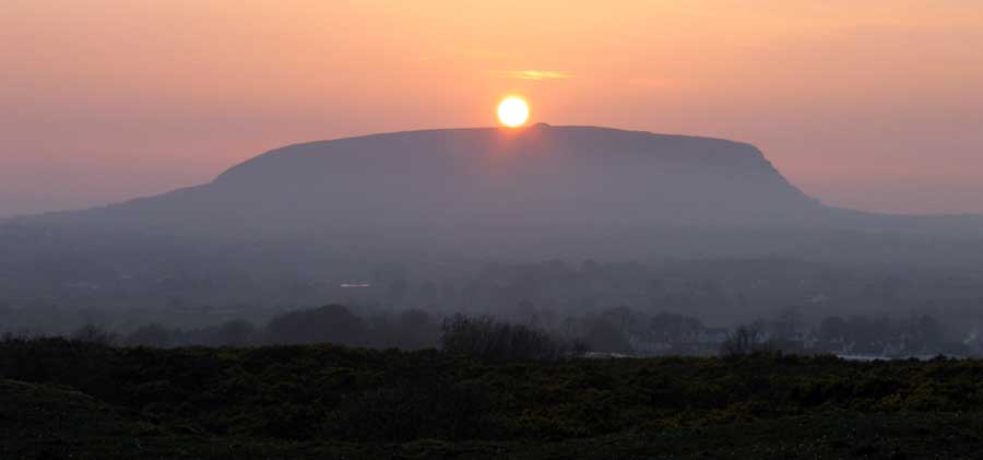
A
dramatic sunset over the massive neolithic Queen Maeve's cairn on the summit of Knocknarea, viewed from the summit of the west cairn of Carns Hill eight days after the autumn equinox. This photo was taken on September 28th 2012.
Carns Hill
Just over two kilometers to the south of Sligo and an easy walk from the center of town, a visit to Carns Hill is to undertake a liminal journey to an ancient and mysterious neolithic landscape, little-known despite the urban sprawl that has crept up around it in recent years.
Carns Hill is actually a double hill with twin summits, the higher west cairn 123 meters, and the slightly lower east cairn at 112 meters above sea level. As the name suggests, the summits are capped by cairns, two huge unopened and undisturbed examples of Irish neolithic passage graves.
The two monuments, known as the east cairn and
the west cairn, are 400 meters apart and both are sited on the highest parts of the flat summits.
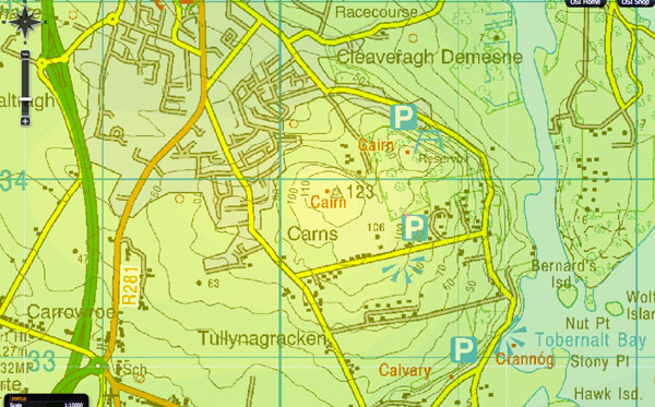
Map showing the location of Carns Hill from the OSI website. The hill is a limestone hum, a hard knob of rock like a mineature Knocknarea on the west side of Lough Gill. Each of the twin summits is capped by a massive neolithic passage-grave, and the position right beside the River Garavogue echoes the location of the more famous younger cousins in the Boyne Valley.
The west cairn has an open view of the horizon and looks to Sliabh Dá Eán just south, Knocknashee, Doomore and Croghaun to the south west, Knocknarea to the west and Benbulben to the north. The east cairn is shrouded in a thick growth of trees, which make the walk to the site quite pleasant, but obscures all views views to the horizon.
Lough Gill, the Lake of Brightness lies just to the east of Carns Hill, and the river Garavogue flows around the east side of the hill and then flows into Sligo Bay. Both cairns are a short walk from the modern waterworks between the two sites.
The following description of the monument has been published by Bergh (1995, 232-3): ‘Located on the flat summit of Carns Hill. The site consists of a cairn with a diameter of 45-49 meters and a height of c. 5 meters. The flat top is slightly hollowed. A rich vegetation of briars covers the summit of the hill, but this vegetation ceases at a distance of c. 10 meters from the cairn, and this area as well as the cairn as such, is covered by grass. Extensive quarrying has been made within the site and especially on the north and west sides. The perimeter of the cairn is however relatively untouched, as the quarrying seems to mainly have been made from the upper edges of the cairn, which is evident from the remaining part of the flat top.
The diameter of 43 meters is calculated from the about 25 kerbstones present along the perimeter of the cairn in southwest. It is notable that nearly all of the visible kerbstones are found at, or very close to, the present edge of the cairn. Evidently the slip of the cairn has not been extensive. The present height is considered to coincide with the original height, as no material seems to have been removed from the dished top.
Stones used within the construction: The cairn consists of locally available limestone, while gneiss has been used for kerbstones, the internal stone revetment, dry-walling, as well as within the two small cairns on the east and west sides of the main cairn.
Kerbstones: About 25 kerbstones are visible within the site, and nearly all are on the southwest side of the cairn. These stones measure c. 0.8 x 0.6m, and all arc gneiss. The have been placed recumbent on the ground with their long-axis forming the perimeter of the cairn.
Internal stone revetment: 15 stones have been recorded c. 3 meters inside the kerb in southwest, describing a curved line parallel to the perimeter of the cairn. These stones measure c.0.5 x 0.4 meters, and all are gneiss which is in contrast with the limestone-built cairn. These 15 stones most likely represent an internal stone revetment which most likely continues all around the monument, even though it can only be traced for a length of 15 meters in the southwest part of the cairn.
Dry-walling: On the North side of the cairn, a drystone walling can be followed for c.5 meters. The stones in the dry-walling are gneiss field stoncs, with a size of c. 0.3 - 0.4 meters. The present height of the dry-walled section is c. 0.4 meters.
Exterior Features
Bank: Along the base of the cairn, mainly on its east side, there seems to be a low bank with a height of only c. 0.3m and a width of c. 4m. It cannot be stated with certainty whether this bank is a part of the original construction or if it is a result of a cairn slip.
Platform: On the south side a low platform runs along the base of the cairn from SE to SW and its outer edge is parallel to the perimeter of the cairn. The width of the platform is about 9m and its height c. 0.3 m. At its western end the outer part of the platform transforms into a bank with a width of c. 2 m and a height of c. 0.4 m. This bank runs for a distance of c. 10m and then ends in a U-shaped curve into the cairn. The bank is, at least in its western part, constructed by stones since the end has the appearance of a U-shaped stone packing.’ (Bergh 1995, 232-3, Fig. 31).
There are four smaller stone monuments immediately adjacent to this cairn, and another large cairn/possible passage tomb is located on a hill c. 400m to NE.
Looking south to the distcintive peaks of Sliabh Dá Eán from the flat summit of Carns Hill West. From here the hills make the shape of a pregnant woman lying down.
The East cairn
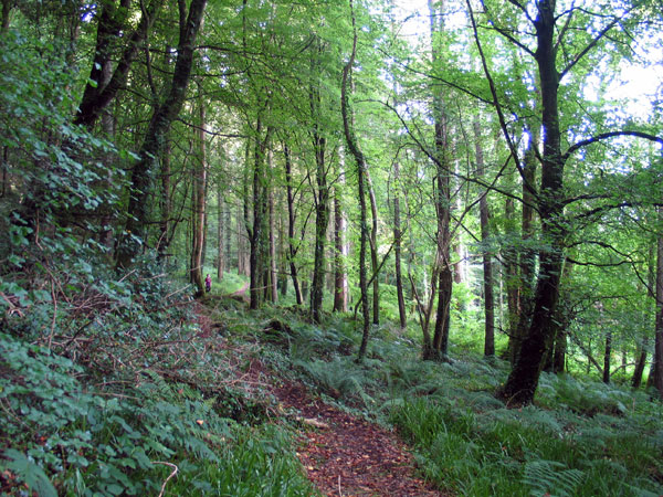
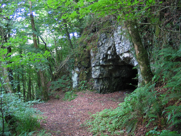
This is the easiest cairn to visit. Parking by the waterworks, take the forest walk path running east; after a few minutes you can take the first trail to the right to climb to the cairn, or continue on down through the forest to visit the cave. All the major megalithic sites in County Sligo have associated caves, and there are two in Carns Hill, one close to each of the neolithic monuments.
The cave is well worth a look, if only because it is the easiest cave in County Sligo to visit. Follow the forest trail for ten minutes and the cave will appear, like something from Narnia, in a cliff on the right. The cave is shallow, some five meters deep, and large enough to stand upright in the opening. It is located in a stretch cliff overlooking the river Garavogue below. A seam of chert runs through the roof of the cave, and it would be worth checking to see if it was ever quarried here.
The cave close to the east cairn.
To visit the cairn, turn back the way you came, and after a few minutes take a left path and follow to the highest point. The cairn is covered with young trees and scrub - ash, sycamore and hazel,
so that you might easily miss it and walk by: it is not that well known,
even in Sligo town less than a mile away. The cairn is quite massive,
being about fifty-three meters in diameter and almost ten meters high. It is composed
of chunks of quarried limestone, and is most likely kerbed and strewn
with quartz.
The site was cleared and surveyed by archaeology students at NUI Galway in 2004, but rapidly became overgrown again. As the cairn is shrouded in forestry, there is no view to the horizon or Knocknarea just eight kilometers to the west, but using maps and Google Earth we can get some idea of the alignments.
This large cairn, a possible passage tomb, is a National Monument in State ownership (no. 568). The following description of the monument has been published by Bergh (1995, 232): ‘The site is the easternmost of the two and overlooks the Garavogue River, 700 meters to the east. The site consists of a large, flat-topped cairn with a diameter of 53-58 meters, and a height of c. 7.5 meters. The cairn is placed at the northern end of a ridge that forms the summit. The hillside declines close to the cairn on all sides except to the south where the ground is level. Immediately to the west of the cairn there is a fairly steep, but short slope of only c. 3 meters, and the cairn has evidently on purpose been placed along this edge.
The site is situated in a deciduous forest and is not visible until one is nearly at it. It is today wholly covered by a rich vegetation of bushes and smaller trees. This thick vegetation is probably the reason why the plan of the cairn never has been recorded before, and it definitely was the reason to why it was not measured by Wood-Martin according to the following: “Its circumference at base could not be ascertained, owing both to the uneven nature of the ground and to its being surrounded by trees, and a close undergrowth of briars, furze, & c.” (Wood-Martin 1888, p. 123).
Minor quarrying seems to have taken place in the southeast part of the cairn, and on the flat top there are several hollows and depressions which are the remains of earlier diggings into the cairn. A number of small semi-circular stone walls are present within the site, and are most likely of modem date.
Dimensions: Diameter, 53 meters (present minimum diameter/original maximum diameter). Height, 7.5 meters (present and original). Diameter of top, 23 meters (present maximum diameter).
The diameter of the cairn is 53 metres north - south, but 58 meters in east - west. The slip of the cairn seems to vary, and has probably been greatest towards the W due to the short but steep slope here. The E and S sides of the cairn are the best
preserved, and the diameter of 53 meters is considered as being a maximum for the original diameter The flat and slightly hollowed top has a maximum diameter of 23 meters. The ground level outside the cairn is 2 meters higher on the south and east, than on the north and west sides of the cairn. The absolute height of the cairn is c. 7.5 meters.’ (Bergh 1995, 232, Fig. 30).
Another cairn/possible passage tomb, very similar in size and construction, is located on a hilltop about 400 meters to the southwest.
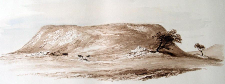
A watercolour of the west cairn by Wakeman, dated 1879. It seems at this time that the monument may have been open, as mentioned by W. G. Wood-Martin, who lived close by.
The west cairn
The west cairn is on private property, and is difficult to visit, as several fields of
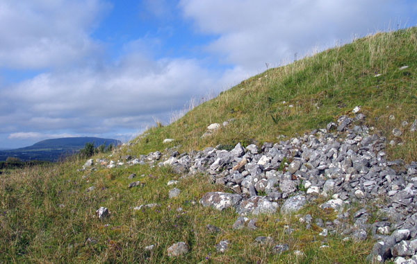
scrub and rough, boggy pasture must be crossed to see it. The last time I visited, it was almost impossible to get in and out through the maze of gorse bushes surrounding the monument. The cairn is about forty-five meters in diameter and eight meters high, and somewhat more delapidated than when Wakeman drew it in 1879.
The cairn is composed of ragged chunks of limestone, probably quarried close by; there is
a large scar-like gully on the west slope of the hill which may be the remains of a quarry.
A line of kerbstones is clearly visible on the southeast side of the cairn; eight kilometers to the west is Knocknarea and Queen Maeve's cairn.
A line of small round
gneiss kerbstones are visible in places, especially on the southeast side, peeping out from under the cairn
slip. Swedish archaeologist Stefan Bergh surveyed the site in the early 1990's and noted a large boulder
which may be a fallen standing stone, and an alignment of boulders on
the north side. The boulder is easy to find, but I couldn't locate the
alignment. Bergh also noted a low platform running around the cairn, parts
of which can be clearly seen on the south west side.
Platforms or tertres are a fundimental and essential element of the earlier passage-graves like the smaller open air monuments found at Carrowmore four kilometers to the west. These platforms, largely overlooked by modern Irish archaeologists, generally support central chambers which were used for burials. At the larger later monuments such as Listoghil, Queen Maeve's cairn and Carns Hill east, the platforms are still present, but no longer contained within, but containing the ring of stones which bounds the cairn.
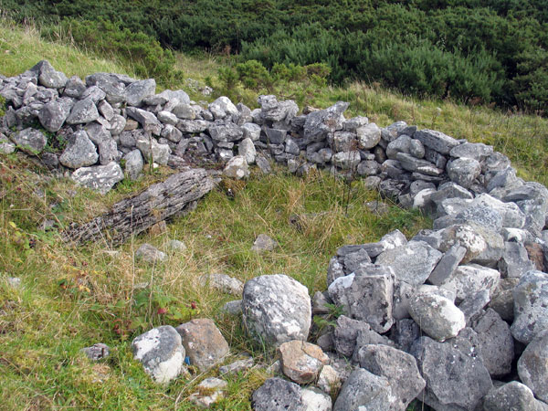
Modern rummaging may have uncovered part of the hidden passage into the west cairn.
Also on the southeast side is a modern wall where someone had been bush drinking - there were plenty of cans and bottles lying around when I visited. A small hollow had been dug on the south side near the dished platform summit, with low drystone walls thrown up to keep the wind off the drinkers. A large flat slab can now be seen,
which is probably one of the covering stones of a hidden passage, which has a general orientation towards the winter solstice sunrise. This means that Carns Hill west is yet another early incarnation or ancestor of a Newgrange style monument.
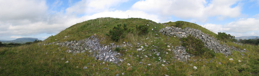
A panoramic shot of the west cairn looking west to Knocknarea 8 km away; the disturbed mound of stones to the right may mark the opening.