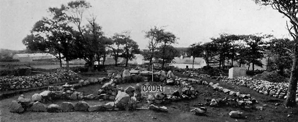
Creevykeel looking west across the fully-excavated monument in 1935.
LONG CAIRN AT CREEVYKEEL, CO. SLIGO.
By H. O'Neill Hencken, D.Litt., F.S.A., Fellow. Summary.
[Comnmnicated]
This cairn is part of the series of megalithic monuments that stretches across the northern part of Ireland from Carlingford Lough in the north-east to the western coast. There is a parallel group in south-western Scotland. The original form was a long cairn with a deep semicircular facade at the eastern end, near the middle of which a doorway leads to a long subdivided gallery.
In the later monuments of the typical series in both Scotland and Ireland,
the facade gradually disappeared. In north-western Ireland, however, an aberrant group developed in which the semi-circular facade increased until it formed an enclosed court at the end of the cairn. To this stage Creevykeel belongs, but it is also related to the normal series in having at its eastern end another very slightly concave facade of late type. The final development of the aberrant group is exemplified by the famous Deerpark monument, also in Co. Sligo, where the court is in the middle of the cairn and has burial chambers at either end.
The greater part of the original contents of the cairn, Neolithic A pottery and flint tools, are, like the architectural prototypes of the site, plainly derived from north-eastern Ireland. The lack of local flint has lead, however, to interesting experimentation with different grades of chert. At Creevykeel the one survivor of the three side chambers is a small passage grave. This, and perhaps also the buff ware and clay balls, point to a connection with the well-known series of passage graves that spread north-westward from the Boyne Valley until they also reach Co. Sligo. This monument is thus an interesting composite of different types.
It is tempting to wonder whether the whole cairn represents one or more periods of construction, and especially whether the double revetment on the south side and the passage grave (Chamber A) may not represent some alteration. But no real evidence of this came to light.
Chronologically the site belongs to the Early Bronze Age of these islands.
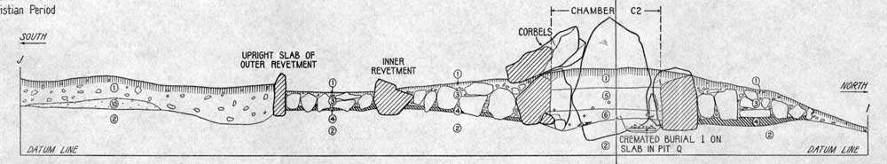
By the Early Christian Period the cairn was already dilapidated and was occupied by iron smelters, who built an enigmatic structure associated with hearths in the court. Traces of iron smelting have been observed at similar sites in Ireland, and the analogy of the Berkshire long barrow called Wayland's Smithy leads one to speculate on the association in early times between tombs of a forgotten epoch and the magic craft of the smith.
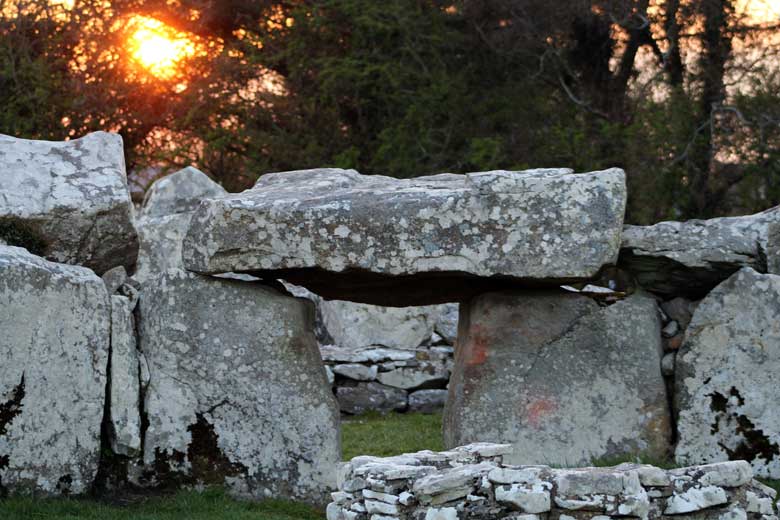
Sunset at Creevykeel; the monument has an astronomical function, being aligned to the sunrise on the Spring and Autumn equinoxes. Notice the 'lip' on the inner end of the lintol: watch your head as you enter!
Acknowledgments
The Harvard Archaeological Expedition in Ireland wishes gratefully to acknowledge the kind and generous assistance of the following, without which the excavation would not have been possible: -
The Commissioners of Public Works of the then Irish Free State for licensing the excavation.
The Right Honourable Lord Mount Temple, P.C., who not only permitted the excavation upon his land but did everything to facilitate it, even to granting permission to cut down twenty-five trees and to remove boundary walls. Lord Mount Temple has also generously donated the finds to the National Museum of Ireland, and has placed the site in the guardianship of the Commissioners of Public Works.
The American Council of Learned Societies and the Milton Fund and Clark Bequest of Harvard University for financial assistance.
Dr. A. Mahr, M.R.I.A., Director of the National Museum, and Mr. H. G. Leask, M.R.I.A., Inspector of National Monuments, for helpful visits to the site.
Mr. Henry Morris, Deputy Chief Inspector of Schools, Ministry of Education, Dublin, for showing the writer numerous megalithic monuments in Sligo and for his help in selecting this site for excavation.
The officers and staff of the National Museum of Ireland, under whose auspices and in co-operation with which the Harvard Expedition has always worked, for every necessary facility, and also the Division of Natural History of the National Museum where the identification of the animal bones was done under the supervision of Mr. A. W. Stelfox, M.R.I.A., Deputy Keeper, by Mr. J. Hyland.
Mr. A. Farrington, C.E., for identifying the stone of which the stone objects were made and for geological information about the locality.
The Sisters of Mercy at Mullaghmore and Dr. H. L. Movius, Assistant Director of the Harvard Archaeological Expedition, for making the preliminary arrangements for the excavation, and Messrs. Andrew Mitchell, John Hannon and Peter Gilmartin of Creevykeel for invaluable local help.
The following friends whose careful work over a long period at
the excavation made
possible this report: Mr. Liam Price, D.J., M.R.I.A., member
of the Ancient Monuments Advisory Council;
Dr. Joseph Rafter,y National Museum of Ireland; Miss Mary Eily de Putron, National Museum of Ireland; Miss Agnes J. W., Newbigin, M.A., Somerville College, Oxford; Mr. G. F. Wilmot, St. Catherine's College, Oxford; Dr. W. W. Howells, Research Associate in Physical Anthropology, American Museum of Natural History; Mr. Lauriston Ward, M.A., Curator of Asiatic Archaeology, Peabody Museum of Harvard University; Dr. Gordon Macgregor, formerly Assistant in Anthropology, Harvard University; and Mr. Antelo Devereux M.A., of Harvard.
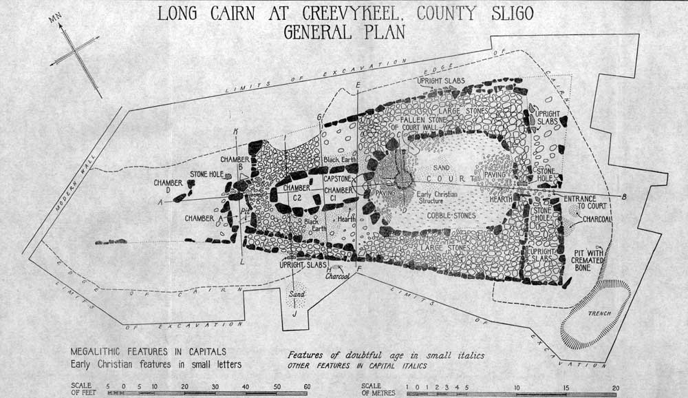
Plan of Creevykeel from 1935.
The Site.
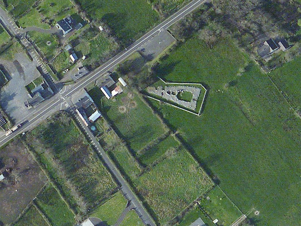
This monument is situated in the Townland of Creevykeel, Parish of Ahamlish, Barony of Carbury. It lies immediately to the east of the hamlet of Creevykeel and close beside the main road from Sligo to Bundoran.
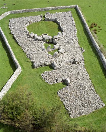
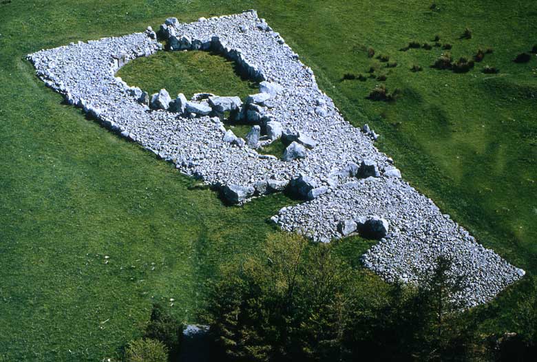
An aerial view of the Creevykeel area showing crossroads and carpark.
The nearest point on the shore is at Bunduff Strand, one and a quarter miles to the north. The town of Mullaghmore lies two miles north-northwest The cairn stands on the northern edge of a spur of a low ridge of glacial till and just above the 100-foot contour. It is marked "Giants' Graves" on the 6-inch Ordnance Survey map of Sligo, Sheet 3.
Two hundred metres north-east there remained recently enough to be marked on the same Ordnance sheet another "Giant's Grave," but this has now been removed. Six hundred metres west-southwest is shown a third "Giant's Grave," now represented by traces of a mound and two upright stones. There are also some small stone forts 20 to 25
metres in diameter in the vicinity of the site, but they are probably much later in date.
The excavation was carried out by the Fourth Harvard Archaeological Expedition in Ireland between July 25 and September 4, 1935. Twenty-seven men were engaged on the excavation, in the course of which the entire cairn was removed and replaced. It measures 55.5 metres long, and at its eastern end, which is the wider, its greatest present width is 25 metres. It tapers toward its western end, but there its outline is indistinct.
Before excavation it was barely 1 metre high at its highest point. It is uncertain whether the eastern end, as is generally the case with these monuments, was originally the higher as well as the broader, but excavation showed that the builders had used the natural slope of the ground to obtain there the effect of height. The monument is entirely of local grey sandstone, and rests upon a natural subsoil of greyish yellow glacial till.
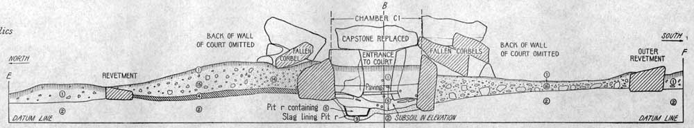
Section of Creevykeel from Hugh O'Neill Hencken's excavations in 1935.
The Structure of the Cairn.
The Revetments.
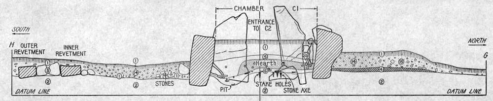
The main body of the cairn was surrounded by a stone revetment to hold the mound together, but which was not intended to be seen as an architectural feature. The eastern end of this is slightly concave, a reminiscence of the form of the horned cairns. In three places the wall is double, at the east end, at the north-east corner, and at the western part of the south side. The north-eastern corner is partly destroyed but enough remains to indicate its outline. The western ends of both walls are also mutilated.
Creevykeel from the air.
Though no sockets had been made to hold the bases of the stones, many of them had sunk of their own weight a little way into the till. In some cases their bases were braced with small stones. This latter feature was especially noticeable in the outer wall at the east end. What now remains of the revetments in most places is plainly only the foundation of something higher, for here and there two and three other courses of dry masonry still exist above the foundation course. The maximum height the of the walls is now 1.50 metres, but they average no more than about 60 centimetres.
Part way along each side their character changes abruptly. To the east they are made of bulky stones set on edge, and to the west they consist mainly of slabs laid flat. The inner wall at the east end differs only in having slightly smaller stones, and the inner one on the south side by having bulky stones but laid on a flat side. Why the revetment was double at this spot is hard to decide. Since neither part continues exactly the line of the adjoining single wall, it is unlikely that either was added in connection with the building of Chamber A.
Since the space between the revetments was filled with the same large stones that elsewhere formed the base of the cairn, it could not have been a chamber. Despite numerous features that suggested construction at different periods no real evidence was forthcoming.
Against the outside of the revetments there had been placed here and there upright slabs. These, reinforced by the weight of the bank of earth and stones that must have formed the outer edge of the cairn, helped support the revetments. At the south-east corner a large stone had been placed as a buttress, and between it and the wall there remained a tight packing of small stones.
Hencken's plan of the main chamber at Creevykeel.
Structures Inside the Cairn.
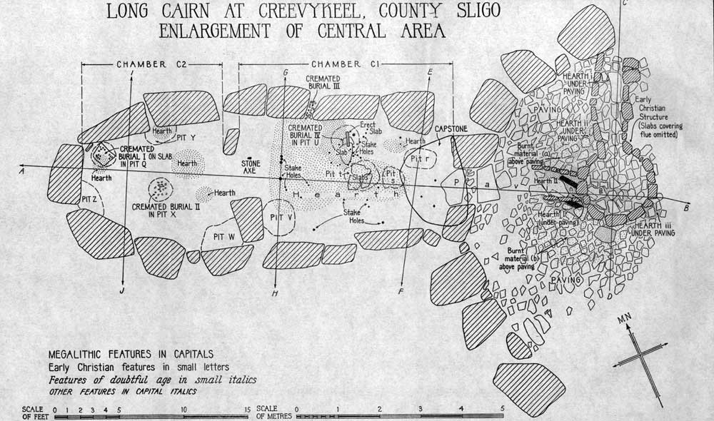
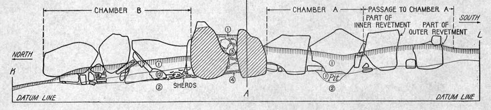
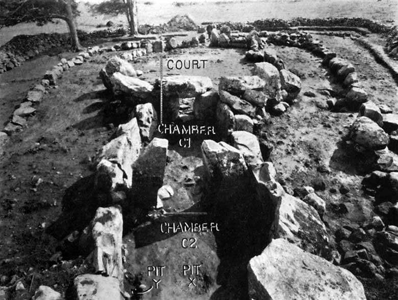
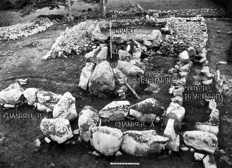
From the middle of the eastern end a passage led to an open court, at the opposite end of which was a large double Chamber CT : C2. Behind this were Chamber A and the remains of Chambers B and D.
The passage leading into the court, represented in part by stone holes, was 4-5 metres long and 1metre wide. If this passage had been linteled, it would have been just over a metre high inside.
The court to which the passage leads is an oval 15 metres long and 9 metres wide and is surrounded by a wall of upright stones with their flat faces inward and their bases slightly sunk in the till. This serves as an inside revetment to this part of the cairn. The western end of the court is formed by a semicircle of eight stones much larger than the others, the tallest of which is 2 metres high, This plainly represents the facade typical of the more usual long cairns. These stones also served a practical purpose, for they supported the mound at its highest point where it must have overlain the roof of the principal Chamber CI :C2.
In the middle of the court the stones are much smaller and average about 1 metre in height. They may have been taller at the west end, however, for close to the entrance passage there is a stone 1.65 metres high, but its neighbours are broken.
There is no evidence that these stones carried any dry masonry above them, except perhaps for the truly megalithic semicircle at the western end. There two large blocks remain that have now fallen outside the court
upon the denuded remains of the cairn. They look as though they might have lain upon the wall of large uprights, one on either side of the capstone of the entrance to Chamber CI. There are, however, a few bits of dry masonry in the wall of the court consisting of little horizontal slabs placed one upon another to close gaps between the uprights. On the same side of the court one of the large stones has been rolled inward to give a vent to the 'flue' connected with the Early Christian structure.
In the eastern entrance and in the neighbouring end of the court was found a rough paving under which had been a small hearth. The paving was adjoined on the sides of the court by areas of cobble-stones. At the western end was a paving similar, except for a small late addition, to that at the eastern end. In the middle of the court was a shallow irregular pit 25 centimetres deep and filled with grey sand, obviously from the neighbouring beach. Paving, cobble-stones and sand all lay directly upon the till and appeared to be in the main the original flooring of the court.
This impression was strengthened by finding on this flooring at the eastern end and in the eastern entrance, as well as in the layer of brown soil and stones that covered it, Neolithic A and Bronze Age sherds. But it should be added that the loose and stony character of this layer had allowed it to be penetrated to all depths by iron slag, glazed sherds and other rubbish dating from Early Christian to modern times. At least part of it was probably material from the bank of earth and stones that usually sealed the entrance to the burial chambers in such monuments, and which in this case the Early Christian occupants would have thrown back.
In the eastern entrance and extending a little to the south of it there was found between the paving stones, and like them lying directly on the till, a thin chocolate coloured layer which covered a polished diorite axe. This axe also lay upon the till and was placed exactly in the middle of the outer end of the eastern entrance. This must be a deposit of megalithic times, especially since another stone axe was found in the megalithic stratum at the entrance connecting Chambers CI and C2. Hence the paving stones, as well as the dark layer and the axe, are all one contemporary deposit. Further evidence on this point is supplied by excavations in similar Irish sites, where paving and cobbling occur especially in the forecourt.
Under this paving at the western end of the court were three small hearths where, before the comple tion of the monument, fires had burned long enough to redden the till.
The later addition to the paving referred to above was in the western part of the court and consisted of stones, for the most part noticeably larger than the others. This area of later paving, which was on the same level as that of megalithic date, and not clearly demarcated from it, lay at one end in the Early Christian stratum in the entrance to Chamber CI, and at the other overlay Early Christian Hearth I, which contained iron slag. It represented merely a patch inserted into the older pavement by the Early Christian occupants partly to cover their own disused Hearth I. They must have removed some of the original paving here to make a pit for this hearth.
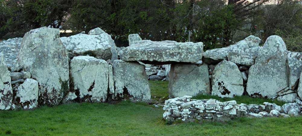
In the middle of the semicircle of large stones at the western end of the court is the entrance to Chamber CI :C2. This consists of a portal flanked by two heavy upright blocks about 80 centimetres apart and 1 3 metres high. The lintel, which had originally rested on them, had fallen into Chamber CI. This measures 2 metres by 1.50 metres by 50 centimetres.
In order to excavate this chamber thoroughly it was necessary to replace the lintel on its original supports. Such "restorations" are often deplorable, but here it was the only way of disposing of the stone to permit complete excavation. In Plates X and XI the capstone is shown as found, and in the other plates as it was replaced.
The double Chamber CI :C2 is 9 metres long and 3 metres wide, and is divided in two by a pair of jamb-stones so placed that CI is slightly larger than C2. The megalithic stratum of light brown soil was continuous between them, showing that no sill stone had ever existed there. The walls consist of thick slabs of sandstone set on edge and averaging 1.25 metres high. They are sunk slightly into the till and in places are braced below by small stones. Small stones were also used to fill the spaces between the large slabs, and in one spot in C2 this took the form of the same kind of dry walling that has already been referred to in the court.
In CI the uppermost western corner of the largest stone on the south side has been broken off, not necessarily by artificial means, and an aperture 35 by 60 centimetres was formed there which left the Early Christian occupants a means of access to one of their hearths, which was just outside the chamber at this point. There is no reason to suppose that it was more than an accidental feature of the original structure. No doubt the cairn had originally covered the chambers completely, but by Early Christian times it must have been much denuded.
The double chamber was originally 2 metres or more high inside. This is shown by the heights of the large end stone of C2, the jamb stones, and the remnants of heavy corbelling. The tapering shapes of the large end stone and the jamb-stones are also adapted to corbelling. Similar slipped corbels have been observed at Clady Halliday and Balix, both in Co. Tyrone.
Hugh O'Neill Hencken was born in New York City on January 8, 1902, the son of Albert Charles and Mary Creighton O'Neill Hencken. He spent his youth in Pennsylvania, and went to Princeton University in 1920. He graduated from Princeton with an A.B. in 1924 and went on to Cambridge University to receive a B.A. (1926), an M.A. (1929), and his PhD in archaeology in 1930.
Hencken received numerous honorary degrees from institutions that included Cambridge University and the National University of Ireland. He was appointed Associate in European Archaeology at Harvard University in 1930 and was made Assistant Curator of European Archaeology at the Peabody Museum the following year. He was Curator of the same department from 1933-1960, and also taught at London, Oxford, and Edinburgh universities during this period.
Hencken married Mary Thalassa Alfred Cruso on October 12, 1935. They had three daughters: Ala, Sophia, and Thalassa. His wife, who had a diploma in archaeology from London University, died June 11th, 1997.
From 1955-1960 Hencken served as the Director of Prehistoric Studies at the American School of Prehistoric Research. He was a Lecturer in Anthropology at Harvard University in 1943-44, 1948 and 1956.
Hencken conducted excavations and museum research on Iron Age peoples and objects in England, Ireland, Morocco, Algeria, Italy, Greece and elsewhere in Europe and North Africa. A member of professional and academic societies too numerous to mention, Hencken was also a prolific writer, publishing excavation reports, articles, and books on his work in Europe. He died in 1981.
Obituary
HUGH HENCKEN, 79; NOTED ARCHEOLOGIST AND MUSEUM CHIEF
by JOSEPH B. TREASTER, SEPT. 4, 1981
Hugh O'Neill Hencken, a leading American archeologist who specialized in the Iron Age in Europe, died Monday at a nursing home on Cape Cod. He was 79 years old.
For 40 years, until 1972, Dr. Hencken served as curator of European archeology at the Peabody Museum of Harvard University. From 1945 to 1972 he also served variously as director and chairman of the American School of Prehistoric Research, the research division of Peabody.
In later life he continued at the museum as the honorary curator, working in research and occasionally giving lectures at Harvard. He had homes in Boston and in Marion, Mass.
In the early part of his career Dr. Hencken conducted archeological digs in England and Ireland. In the late 1940's he directed digs in Algeria and Morocco and since about 1950 he concentrated on the analysis and synthesis of ancient materials in museums across Europe. Pre-World War I Collection For the last 15 years, Dr. Hencken had been studying a collection of antiquities discovered at sites in Germany and Central Europe before World War I. He had been instrumental in obtaining the artifacts, known as the Duchess of Mecklenburg Collection, for the Peabody. Dr. Hencken wrote three books on the collection and was working on a fourth. Altogether, he had written a dozen books. In perhaps his most ambitious dig, Dr. Hencken supervised a joint team of American and Irish archeologists, anthropologists and ethnologists in excavations in Ireland from 1932 to 1936.
One of their early finds, recovered from a clay mound near Moate in County Westmeath, was a large wooden building that Dr. Hencken and the others believed was a lake house constructed by the Celts, who traveled to Ireland from the continent in the Bronze Age.
Dr. Hencken was born in New York Jan. 8, 1902. He received a bachelor of arts degree from Princeton University in 1924 and a doctorate at Cambridge University, England, in 1929. He became the curator of European archeology at the Peabody in 1932.
Dr. Hencken served as president of the Archeological Institute of America from 1952 to 1955. In 1935, while excavating in Ireland, Dr. Hencken met Thalassa Cruso, of England, who had studied archeology under Sir Mortimer Wheeler, and later married her. She was his second wife; the first Hencken marriage ended in divorce.
Miss Cruso later became known to the public through her gardening show on National Educational Television, ''Making Things Grow.'' In addition to his wife, Dr. Hencken leaves three daughters, Ala Reid, Sophia Stone and Thalassa Walsh, and seven grandchildren. A private funeral was held yesterday.
Source: New York Times.
BIBLIOGRAPHY OF LONG CAIRNS AND RELATED MONUMENTS EXCAVATED IN IRELAND.
Aghnaskeagh A, Co. Louth. E. E. Evans, County Louth Archaeological Journal, vol. VIII (1935), pp. 235 ff.
Aghnaskeagh B, Co. Louth. E. E. Evans, Ibid., vol. IX (1938), pp. 1 ff.
Ballyalton, Co. Down. E. E. Evans and O. Davies, Proceedings of the Belfast Natural History and Philosophical Society, 1933-4, pp. 79 ff.
Ballyedmond, Series, N.S., vol. Ill (1937), p. 454. Co. Down. E. E. Evans,
Preliminary Ulster Journal
Clontygora,
1936-7,
Clontygora, Ulster
pp. 20 ff.
Co. Armagh
T. G. Series,
F. Paterson and vol. II (1939), pp.
Co. Londonderry. E. E. Evans, Proceedings
of the Prehistoric
report only. of Archaeology, 3rd
Ballybriest, Society,
of Antiquaries of Ireland, vol.
vol. I (1938), pp. 49 ff. Ballynamona, Co. Waterford. T. G. E. Powell, Journal of the Royal Society
Ballyrenan, Co. Tyrone.
O. Davies,
LXVIII Journal
(1938), pp. 260 ff. of the Royal Society
of Antiquaries
vol. LXVII Browndod, Co. Antrim. E. E. Evans
Natural History and Philosophical Carrick East, Co. Londonderry. J.
pp. 89 ff. and O. Davies, Proceedings
of Ireland,
(1937),
of theBelfast Society, 1934-5, pp. 70 ff.
Co. Tyrone. II (1939), pp.
Co. Armagh. VIII (1934),
E. E. pp. 165 (long
Belfast
Evans, ff.
Ulster Journal of Archaeology, County Louth Archaeological
3rd Series, Journal,
Paterson, Society,
O. Davies, 55 ff.
Co. Armagh Proceedings of the
cairn). Natural
cairn). 3rd
O. Davies History
and T. G. F. and Philosophical
(small Journal of Archaeology,
B. Mullin and O. Davies, Ulster Journal of Archaeology, 3rd Series, vol. I (1938), pp. 98 ff. Carrowkeel, Co. Sligo, Cam E. R. A. S. Macalister, E. C. R. Armstrong,
R. LI. Praeger, Proceedings
of the Royal 332-3.
Davies and History and
Irish Academy, vol.
C. A. Ralegh Radford, Philosophical Society,
XXIX,
Pro 1935-6,
Section Clady Halliday,
ceedings
pp.
Clogherny, vol.
Clonlum, vol.
C
(1912), pp. 323-4, Co. Tyrone. O.
of 76 ff.
the Belfast
Natural
O. Davies, 36 ff.
Doey's Cairn, Dunloy, Co. Antrim. E. E. Evans, Ulster Journal of Archaeology, 3rd Series, vol. I (1938), pp. 59 ff.
Goward, Co. Down. O. Davies and E. E. Evans, Proceedings of the Belfast Natural History and Philosophical Society, 1932-3, pp. 90 ff.
Hanging Thorn, Co. Antrim. I. J. Herring, Proceedings of the Belfast Natural History and Philosophical Society, 1936-7, pp. 43 ff.
Largantea, 3rd
Co. Londonderry. I. J. Herring, Ulster Journal of Archaeology, Series, vol. I, pp. 164 ff.
Excavations in 1935
Creevykeel
was excavated between July 25 and September 4 1935 by the fourth Harvard archaeological mission, as part of the first scientific excavations in Ireland, and led by Hugh O'Neill Hencken. Twenty seven workers were involved in the dig, and the cairn material was removed entirely (see photo below) and then replaced. They found that the large structural chunks of sandstone are resting on the old ground surface, rather than placed in sockets.
Large areas of the court were paved with small flat slabs and in places, cobble stones. Sea sand from the nearby shore was also found. Evidence of large
fires - cremated bone and charcoal were found in the court. It was also
discovered that the monument was expanded several times. It began as a smaller
monument with an open court, which was eventually enlarged and lengthened
into a full enclosed court.
Revetments were found in the sides of the
cairn, where there were probably drystone walls originally holding up
the sides of the monument. This can also be seen in the alignment of the chamber and the passageway: they are not in line. The later entrance to the court is skewed more to the south. The actual passage is oriented to Arroo mountain. The two axis are marked on Hencken's plan, below.
A photo from Hencken's excavation at Creevykeel, showing all the cairn material removed.
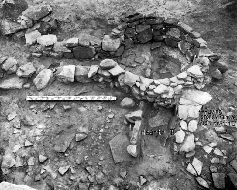
The round feature in the court proved to be an early Christian smelting pit, where
metal was worked. This addition would have been added perhaps 4,000 years
after the original construction of the monument. The Iron age and early Christian metalworkers appear
to have liked working in ancient sites and unusual places such as megaliths
and crannogs, and megalithic sites seem to have perhaps held magical properties in relation
to metalwork.
One of the stones on the north side of the court was pushed over to make way for the smelting pit, and another had holes cut into it, probably to secure some kind of covering over the metalworking area. Two hearths were discovered outside the circular structure.
The smelting pit at Creevykeel.
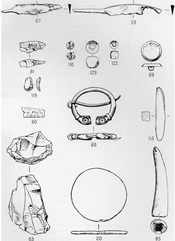
They may well have been animal bone remains from feasting. A piece of worked flint was found in one of the pits. Between the dividing stones that seperate the large chamber they found a polished stone axe.
Other
finds from the inner chamber included a large flint knife, about 13 cm long, arrowheads, pot
sherds, some quartz crystals, and more flint scrapers. Of the three smaller chambers at the west end of the cairn, the badly damaged chamber B on the north side had many fragments of neolithic pottery, the remains of at least 8 pots. Chamber C contained only modern rubbish. Chamber D yielded some flakes of flint and some quartz chips.
Chambers exposed during excavation.
The two polished neolithic axeheads, one from the chamber, the other from the entry passageway at the east end of the cairn. There were plenty of finds from the early Christian period too. The chamber seems to have been unroofed at the time, and there was evidence it had been used: a layer of soil 40 cm deep with bones of ox and sheep and periwinkle shells. Lumps of iron slag and some bronze were found outside the entrance and some 70 pounds of slag were found in the bottom of the smelting pit. Three iron knives and a blue glass bead, and three fragments of pottery were also found.
Finds from Creevykeel
There were plenty of finds from the excavations at Creevykeel, dating to the original neolithic use and the early Christian period. Within the main chambers were four pits which had some token deposits of cremated bone - too few and fragmentary to say if they were a burial.
They may well have been animal bone remains from feasting. A piece of worked flint was found in one of the pits. Between the dividing stones that seperate the large chamber they found a polished stone axe.
Other
finds from the inner chamber included a large flint knife, about 13 cm long, arrowheads, pot
sherds, some quartz crystals, and more flint scrapers. Of the three smaller chambers at the west end of the cairn, the badly damaged chamber B on the north side had many fragments of neolithic pottery, the remains of at least 8 pots. Chamber C contained only modern rubbish. Chamber D yielded some flakes of flint and some quartz chips.
Some of the finds from the excavations in 1935.
There were many finds from the early Christian period. The chamber seems to have been unroofed at the time, and there was evidence it had been used: a layer of soil 40 cm deep with bones of ox and sheep and periwinkle shells. Lumps of iron slag and some bronze were found outside the entrance and some 70 pounds of slag were found in the bottom of the smelting pit. Three iron knives and a blue glass bead, and three fragments of pottery were also found.