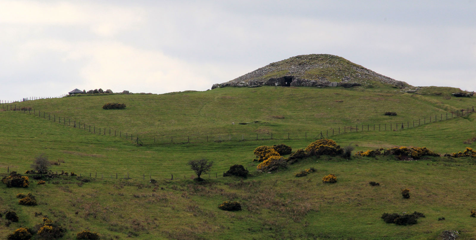
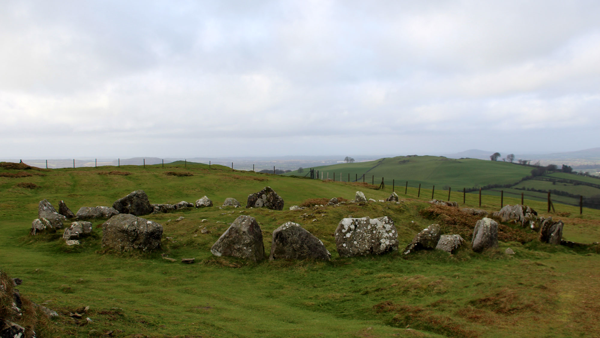
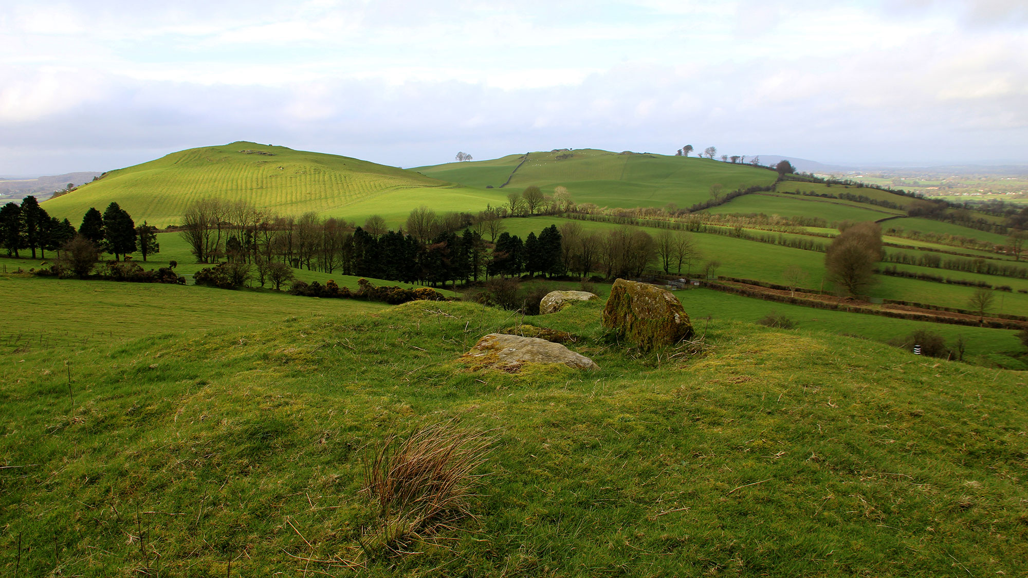
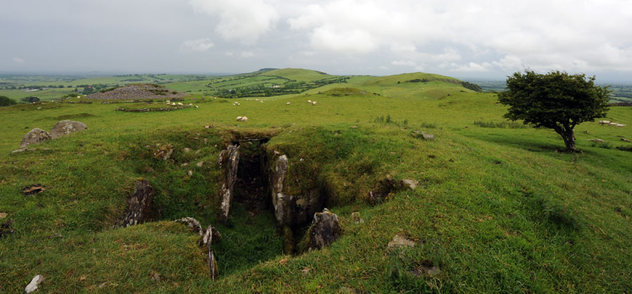
The Loughcrew landscape: Cairn T on the summit of Carnbane viewed from Patrickstown, the most easterly of the four hills of Sliabh na Cailleach.
Loughcrew - Sliabh na Cailleach
Loughcrew is a range of picturesque hills, three miles south-east of Oldcastle. The ridge of the range is about two miles in extent, and there are three chief heights: Slieve-na-Calliaghe, 904 feet; Patrickstown Hill, 885 feet; and Carnbawn, 842 feet: but the name of the first is generally applied to the whole range.
Here, within the radius of a rifle-shot, may be seen grouped together the most extraordinary collection of archaic monuments to be found in the kingdom. These for the most part consist of ruegalithic sepulchres surmounted by tumuli, and surrounded by stone circles. These number 'from 25 to 30 cairns, some of considerable size, being 120 to 180 feet in diameter; others are much smaller, and some are so nearly obliterated that their dimensions, can hardly be now ascertained.'
It is, we think, not too much to say that on the stones among these cairns is found the greatest collection of rude prehistoric scorings yet found in Ireland or, perhaps, in Europe.
Sliabh na Cailleach, or the Mountains of the Witch, as Loughcrew is locally known, lies west of the town of Kells and south of Oldcastle in west Co. Meath, a strange and ancient piece of territory. Stretching in a chain over four tall peaks which spread out across four kilometers from east-to-west, the area is littered with a wonderful collection of monuments from all eras. This is among the most beautiful and powerful landscapes of ancient sites remaining in Ireland. The main attraction at Loughcrew are the thirty remaining passage-graves which, though undated by modern methods, probably date from about 3,500 BC.
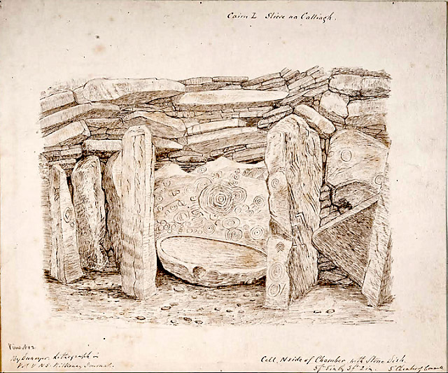
The large and elabourately carved panel of neolithic art within the large right-hand recess of
Cairn L. The watercolour was painted by geologist Victor DuNoyer around 1866. The illustration shows the Whispering Stone, a tall, free-standing limestone pillar, which guards the entrence to the recess. The exquisite neolithic art is illuminated by the light of the rising sun twice yearly, and the symbol is believed to be the oldest currently known illustration of a solar eclipse which occurred in 3,340 BC.
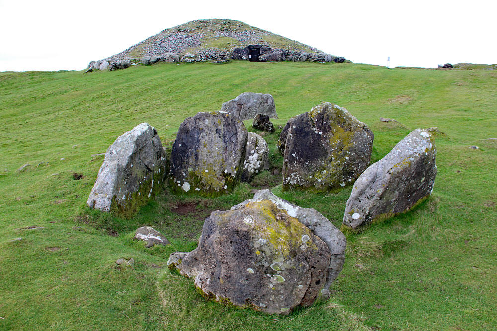
These fascinating structures are cairns of stone ringed with kerbstones which are formed of large erratic blocks placed on end. The remaining openings, which predominantly face to the east, allow access to the interior of the monuments, where chambers once roofed with a sophisticated system of corbelled overlapping stones create artificial caves which were used for ritual purposes, astronomical observations and burial. Possibly the most attractive and interesting feature of the Loughcrew cairns is the incredible corpus of decorated slabs, which constitute a wonderful collection of very obvious solar and astronomical symbolism.
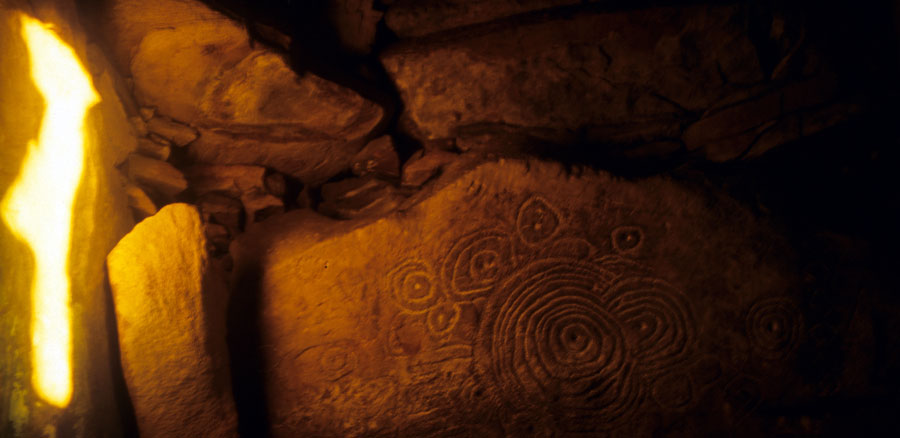
The sophisticated panel of neolithic engravings known as the Equinox Stone, found within the deepest recess of Cairn T, is illuminated each spring and autumn, when the beam of light focuses on the main symbol of the sun. This stunning alignment, which was discovered by Martin Brennan and Jack Roberts in 1980, draws hundreds of visitors to the monuments each year.
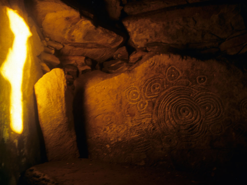
The discovery of two significant astronomical alignments in 1980 by researchers Martin Brennan and Jack Roberts has further increased public fascination with the Loughcrew monuments. On both the spring and autumn equinoxes, the Equinox Stone within the deepest recesses of Cairn T is illuminated in a most sophisticated fashion, by a beam of sunlight which shrinks and narrows to focus on the main solar emblem. A similar and possibly even more spectacular alignment takes place in Cairn L when the sunrises in early November and early February - the cross-quarter days - illuminate a large and complex engraving which researcher Paul Griffin suggests represents the oldest known image and record of a solar eclipse, an event which occurred in 3,340 BC.
Another sophisticated panel of neolithic engravings are found within the deep and dark right-hand recess of Cairn L. This slab is illuminated each November and February, when the beam of light first strikes the mysterious Whispering Stone before entering the recess where the reflected light reveals a stunning panel of art believed to represent a solar eclipse which occurred in 3,340 BC. This stunning alignment, which was discovered by Martin Brennan and Jack Roberts in 1980, has still not gained any real attention from Irish archaeologists or academics.
Visiting Loughcrew
The monuments at Loughcrew are owned by the Office of Public Works the body in charge of heritage and archaeology in Ireland. Until 2018, Cairn T, the central monument was open to the public, free of charge, and the monuments were staffed by seasonal guides stationed there over the summer months. However, there is currently no access to the chamber of Cairn T, due to an ongoing maintainance issue: the concrete roof which was added to the passageway in the 1880's by the Board of Works, is cracked and collapsing. If you should visit the Loughcrew cairns, please help preserve these wonderful ancient buildings: do not climb on the monuments.
Looking northwest across the chamber of Cairn V to the main monument known as Carn Ban, The Hag's Cairn, or Cairn T.
The sites are a steep 15 minute hike up the hill from the carpark. The monuments on Cairnbane West and Patrickstown are not accessible to the general public; the landowner, who keeps huge flocks of sheep up there, does not allow access to the west hill and there is no access to the chamber of Cairn L. Guided tours of the Loughcrew cairns can be booked at the Loughcrew Megalithic Centre, where there is also a small craft gallery and tea / coffee shop.
It is highly likely that this location in the Loughcrew Hills was special or even sacred to the mesolithic hunters-gatherers, the first people to colonise Ireland after the glacial period. The mesolithic people tended to live a nomadic lifestyle and did not build monuments, but held natural features such as boulder-fields, cliff-faces and rock outcrops as their holy places, while dwelling along the coast, by lake shores or river banks.
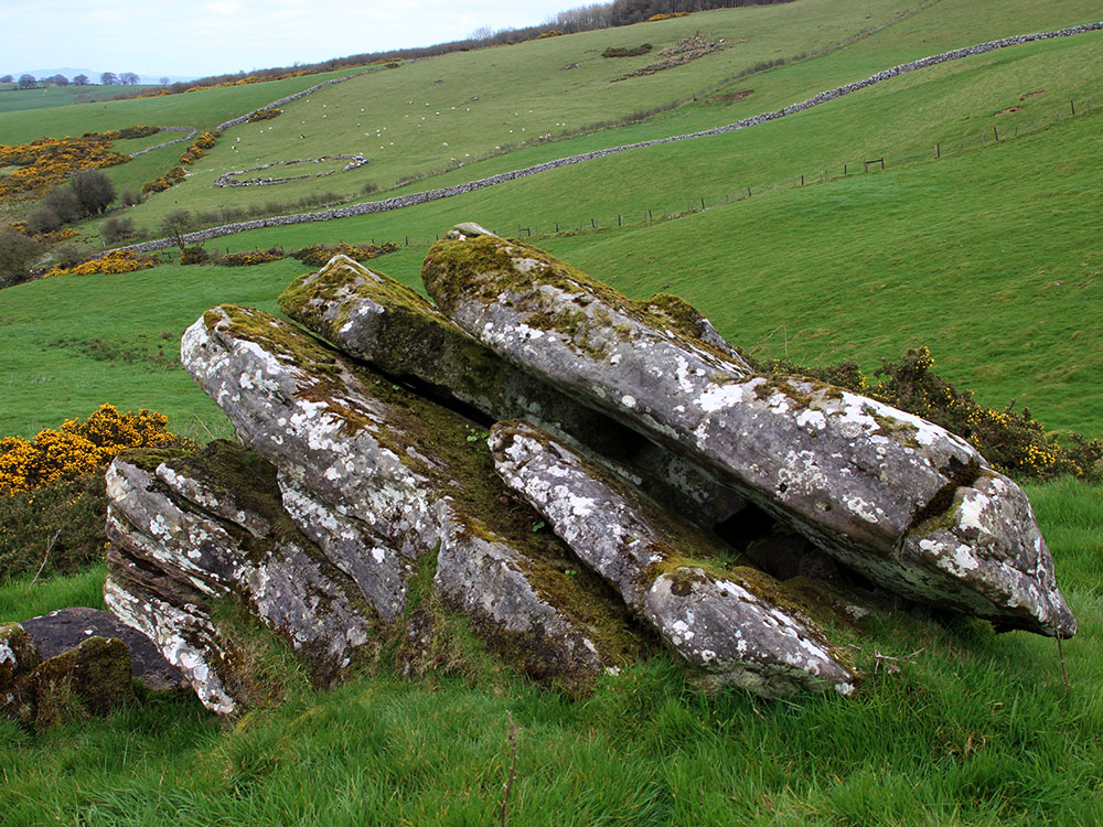
A large sandstone erratic on the east slopes of Carnbane hill shows how the neolithic farmers dismantled and dismembered bolcks of stone to create building materials for their monuments.
The colonising neolithic farmers arriving at Loughcrew by around 3,500 BC built their monuments using the ready supply of erratic boulders, converting the abundant glacial material into slabs to create the internal chambers and passages of their artificial caves. The smaller passage-graves are believed to be the first to be constructed while the larger monuments appear to be younger and later. Jean McMann, a researcher who has written extensively about Loughcrew describes the chambers:
In both designs, the transition from entry to inner chamber is breathtaking. Just after the low passage from the outer world narrows, the space explodes. Shadowy side cells, curtained by sills, lintels and orthostats, expand the chamber boundaries. Huge corbels circle high overhead. Although the vertical emphasis of this kiln-like space strongly evokes the idea of 'centre', it is rarely placed at the central point of the cairn, one of many disjunctions between exterior and interior form. The design of such radically innovative spaces has been little discussed in architectural histories; yet megalithic tombs are milestones in the history of building, and, indeed, the history of art.
Forms of power: dimensions of an Irish megalithic landscape by Jean McMann. Antiquity, September 1994.
Though the monuments at Loughcrew have not been dated with modern techniques, they can be fitted into the chronology of Irish monuments between those at Carrowkeel, seventy-five kilometers to the north-west in County Sligo, and the huge mega-mounds in the Boyne Valley to the east. The oldest neolithic monument currently known in Ireland, the causewayed enclosure at Magheraboy has been dated to 4,150 BC; the use of the early Carrowmore monuments have been dated from 3,800 - 3,000 BC, and Carrowkeel has recently been shown to be in use by 3,500 BC. Newgrange and Knowth are known to be younger, having been used between 3,200 and 2,900 BC.
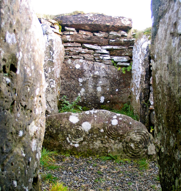
A beautiful set of three spirals carved on the sill stone which protects the north recess of Cairn H on Carnebane West.
Folklore and Mythology
When the neolithic farmers arrived in Ireland, as well as farming and livestock, they imported new religious beliefs which supplanted and replaced the older and more shamanic hunter-gatherer spiritual practices. The principal diety of the neolithic colonists appears to have been female, the great earth goddess who has been called by many names, and is found in the near east, in Egypt and on the continent. In Ireland she is remembered a giant goddess named Garavoge, was a famous builder of monuments among her other talents and skills. The Garavogue arrived in Loughcrew from the north-west carrying a collection of rocks which she dropped from her white apron as she flew from summit to summit: Her exploits and name are remembered in an old poem composed by Jonathan Swift, of Gulliver's Travels fame:
"Determined now her tomb to build,
Her ample skirt with stones she filled,
And dropped a heap on Carnmore;
Then stepped one thousand yards, to Loar,
And dropped another goodly heap;
And then with one prodigious leap
Gained Carnbeg; and on its height
Displayed the wonders of her might.
And when approached death's awful doom,
Her chair was placed within the womb
Of hills whose tops with heather bloom"
Jonathan Swift, c. 1720
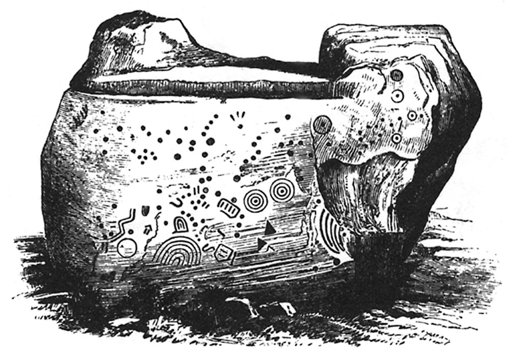
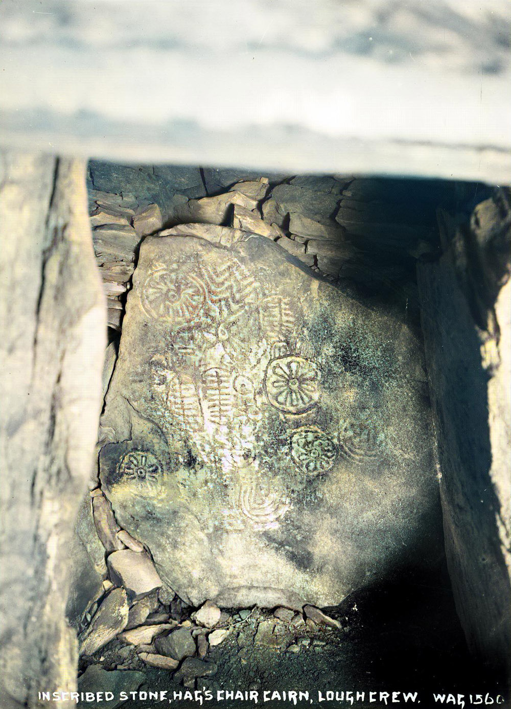
The Cailleach Garavogue is most associated with Cairn T, which was known locally as The Hag's Cairn. The huge decorated kerbstone on the north side of the cairn is called the Hag's Chair, and there are many accounts in both antiquarian writings and local folklore of Garavogue sitting upon her throne surveying her landscape as she smoked her pipe. Stories of a powerful multi-tasking female deity are found throughout western Europe wherever passage-graves were constructed in the neolithic.
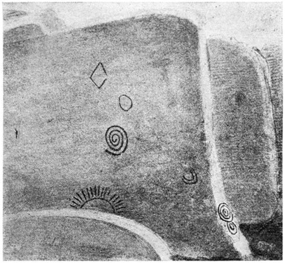
Eugene Conwell's illustration of the neolithic artwork on the Hag's Chair.
Swedish archaeologist Henna Lindstrom published a fascinating study called Casas das Mouras Encantadas – A Study of dolmens in Portuguese archaeology and folklore, in 2014:
Mouras Encantadas are supernatural beings in Portuguese folklore. They live in megalith tombs and guard the entrance to the world beyond. This study compares the archaeological data of the tombs to the folklore - stories, traditions, perceptions and beliefs concerning the tombs. The aim of the study is to determine whether it is possible that some fragmentary material from the ancient religious worldview might have been carried to the present day in the symbolic level.
You can find out more about the great goddess of the neolithic farmers known as Garavogue on her own dedicated page.
The beautiful Loughcrew landscape: the view west to the collection of monuments on Carnebane West from Cairn S.
Engraved Stones and Neolithic Symbolism
The most common style of sculpturing on the inscribed chamber-stones was punched work, executed by a metallic tool; but there are also examples of chiselled work and scraped work. Though the carved stones exceed one hundred in number, there are not two the decorations on which are similar. On the stones which have been long exposed to the destructive effects of the atmosphere, the punched or other work is often much obliterated; but on those lately exposed the work of the tool is almost as fresh and as distinct as at the period of its execution.
Possibly the most fascinating aspect of the Loughcrew cairns is the large collection of early neolithic stones which are profusely carved and engraved with symbols and designs. When Eugene Conwell began digging at Loughcrew in 1863 and realised the enormous body of engravings housed there, he invited his friend the geologist George DuNoyer to illustrate the stones. DuNoyer left us a valuable record, as many of the stones within unroofed chambers have weathered badly since the 1860's.
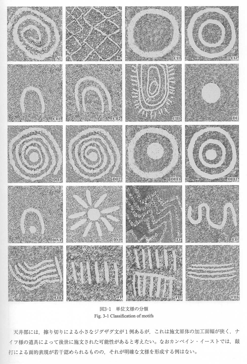
A table of the chief symbols encountered in the engraved art at Loughcrew, taken from the report produced by a team of researchers from Japan who surveyed the Loughcrew monuments in 1978 and 1979.
Many antiquarians, archaeologists and researchers have examined the carved symbols, and there are a whole host of ideas and theories and debates about the meaning of the engravings. Many early researchers noted the profusion of solar symbolism, including explicit carvings of solar imagery in Cairn T, Cairn L and Cairn I. In the 1870's Thomas Deane who was in charge of the Board of Works had the collapsed corbelled roof of Cairn T reconstructed, and a concrete roof added to the passage, and to the chamber of Cairn L, to ensure the protection of the carvings.
In 1924 American anthropoligist George T. Flom published a fascinating paper titled Sun-symbols of the Tomb Sculptures at Loughcrew, Ireland, where he noted parallels between the Loughcrew engravings and ancient Egyptian solar symbolism. Part of Flom's conclusion states:
The two conceptions of the sun which seem evidenced in the Loughcrew symbols, the one as a light and heat giving power, the other as declining at the end of day and appearing beneath the horizon followed by darkness, represent undoubtedly the points of departure of the belief in the twofold character of the sun.
It will help to explain the dual cult, one a god of fruitfulness and another to a death deity, of which Bronze Age rock-tracings and other sculpturings among Indo-Euro peoples seem well-nigh everywhere to give evidence. The Scandinavian rock-tracings seem certainly to reveal a sun-worship in a well-developed stage, with various cults, a nature worship with zoomorphic deities; and here and there we seem to witness emergence of anthropomorphic gods. Of this the Loughcrew groups may represent the beginnings.
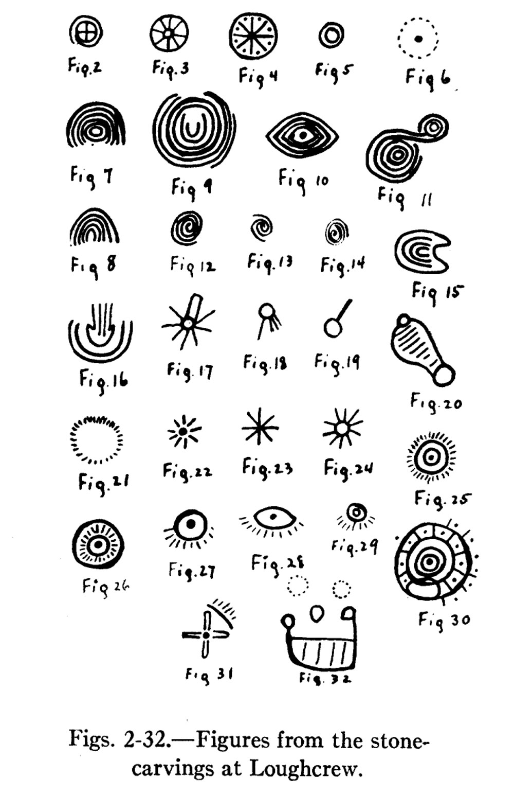
A table of the chief symbols encountered in the engraved art at Loughcrew, taken from the report produced by American anthropoligist George Flom in 1924.
The sun symbol with descending rays represents the sun in the function of bestowing fruitfulness and life. The symbol with cupped circles and ascending grooves in Scotland and England then may be emblem of fertility in nature and in human life. At any it seems likely that sun-worship as evidenced at Loughcrew had a fertility cult as part of it.
Sun-Symbols of the Tomb-Sculptures at Loughcrew, Ireland,
Illustrated by Similar Figures in Scandinavian Rock-Tracings, G. Flom, 1924.
By far the most exciting developments at Loughcrew in recent years were the archaeo-astronomical discoveries made by by Martin Brennan and Jack Roberts in 1980. Brennan's book, The Stars and the Stones, published in 1984, recounts their discovery that the back stone within Cairn T was illuminated by a direct beam of sunlight on the spring and autumn equinoxes. Brennan vividly describes the first time they witnessed the solar alignment:
We were winding up the mountain road when the disc of the sun broke on the horizon. We felt as if we were ten minutes late for an appointment made over 5,000 years ago. From the top of the road there would be a climb on foot to the mound perched on the summit of the mountain. The lock on the modern door leading to the passage had frozen during the night, and as we struggled with it the rising sun was already above the horizon. When we drew back the door a narrow chink of light streamed down the passage and flashed into the end recess of the chamber.
Martin Brennan, The Stars and the Stones.
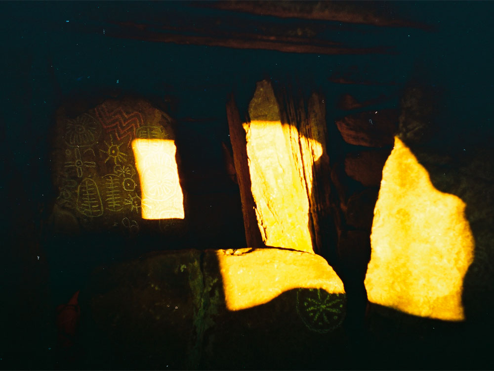
A further fascinating discovery revealed that Cairn L also had an archaeo-astronomical alignment to the sunrises on the November and February cross-quarter days. As the sun rise over Cairn M on Carrigbreac, a beam of light flashes into the chamber of Cairn L and strikes the top of the limestone pillar known as the Whispering Stone in the most dramatic fashion. The beam of light moves into the large right-hand recess, where it is reflected onto a large and complex panel of engraved symbols. The research and discoveries of Brennan and Roberts have largely been ignored by Irish archaeologists, who seem content to believe that the famous and precise alignment to the winter solstice sunrise at Newgrange appeared out of nowhere, ignoring any evidence of prior research or experimentation by the neolithic farmers.
The Loughcrew eclipse carving in Cairn L illuminated by the reflected light of the rising sun, November 8th, 1997.
A Solar Eclipse at Loughcrew in 3,340 BC
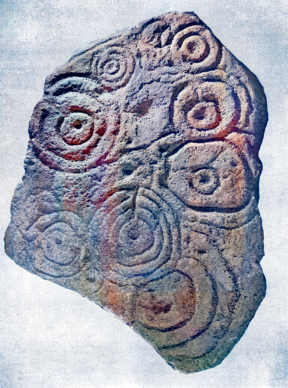
More research on the astronomical symbolism of the Loughcrew carvings was published in 2006 when Paul Griffin noted that the carvings in Carin L are highly likely to be a pictorial depiction of the solar eclipse which occurred over Loughcrew in 3,340 BC. This date would fit in well with the current suggested chronological narrative of Irish passage-grave construction. Griffin's research, which made headlines in news and science journals around the world, was met with skepticism when it was not ignored completely by the Irish archaeological establishment.
An illustration of the rising sun carved on the bottom of the east orthostat within the large right-hand recess of Cairn L, by George DuNoyer. From this viewpoint the rising sun can ve viewed on the November and February cross-quarter days, as it emerges from Cairn M on Carricbreac. The sun enters the chamber, strikes the top of the pillarstone known as the Whispering Stone, before flashing into the recess to illuminate the eclipse carving.
Is Griffin’s interpretation correct? It’s impossible to know for sure. The people who created the carvings didn’t leave behind any writings to explain their purpose to curious onlookers 5,000 years in the future.
But Griffin’s explanations were convincing enough for NASA to include his ideas in their roundup of eclipse history. Lunar scientist John Dvorak also included them in his recent book on eclipses, “Mask of the Sun,” although he notes that the meaning of the carvings is “open to debate” and that “no one knows for sure exactly what the concentric circles represent.”
The story does not end there! Canadian eclipse researcher Robin Edgar has proposed that several carvings within the neolithic repertoire, such as the Stone of the Seven Suns at Dowth and the large and exquisitely carved basin stone found in Knowth east can be viewed as clear representations of eclipse symbolism. Two stone urns or basins were discovered at Knowth, one of which has long since vanished but was illustrated. Both show what can reasonably be interpreted as eclipse symbolism.
Griffin's research in Cairn L would seem to correspond with Edgar's theory. Both theories accord with the suggestion by Canadian academic and lunar expert Philip Stooke, who has postulated that symbols carved in the chamber of Knowth east are the oldest currently identified map of the surface of the moon. However, once again, Irish archaeologists are not interested, and leading experts in neolithic art continue to insist that the engravings at Loughcrew are abstract, and that we can never know or understand what they mean. An Irish blogger summed up the views of the academic establishment succinctly when he recently stated that:
Anyone who claims – with even a modicum of certainty – that they know the full meaning of a stone's symbols, is most probably a charlatan, or at least someone whose expertise should be questioned, since those who have studied these monuments in the greatest detail, over the longest periods, are uncertain about almost every aspect of them.
The following is a brief summary of the history of research and excavation at Loughcrew, and I am working on a more detailed account on a dedicated page.
The Loughcrew cairns were first mentioned in writing in modern times by Louisa Beaufort, who published an article in 1828. The site was visited by John O'Donovan and the sappers working for the Ordnance Survey, who used the chamber of Cairn T for their base during their work there in the 1830's. In the early 1860's a local school inspector named Eugene Conwell, claimed to have discovered Loughcrew, though William Wakeman also claims to have found the site around this time.
Conwell conducted a series of crude excavations from 1863 and published numerous accounts of his explorations and finds to the Royal Irish Academy and other academic bodies. Conwell excavated the majority of the Loughcrew monuments and gave them the letters still used today. His writings are still the primary source for information on Loughcrew. Conwell invited his friend, the geologist and talented artist George DuNoyer to illustrate the megalithic art at Loughcrew, and these watercolours are a valuable record of many stones, such as the Hag's Chair, which have eroded greatly since.
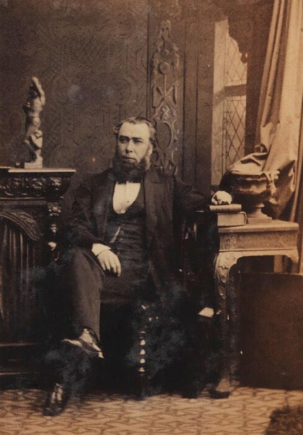
Eugene Alfred Conwell photographed by Camille Silvy. The image is an albumen print, taken on 28 August 1862 in Silvy's studio at photographer's studio, 38 Porchester Terrace, Bayswater, London, two years before Conwell 'discovered' Loughcrew. Source.
The famous Sligo antiquarian and author W. G. Wood-Martin examined a series of bone and antler pins discovered by Conwell, and compared them with similar artefacts from his own excavations at Carrowmore in County Sligo. Thomas Deane, head of the Board of Works had the largely collapsed corbelled roof of the chamber at Cairn T reconstructed, and also oversaw the addition of concrete roofs to the passage of Cairn T and the chamber of Cairn L in the 1800's.
E. C. Rotherham, an enthusiastic antiquarian who owned land on Patrickstown hill excavated Cairns R and R1 on Carnbane. George Coffey, Keeper of Antiquities in the National Museum also conducted minor excavations in the 1890's. Coffey analysed the engraved stones, and largely considered the symbols to be ornamental. He also noted a connection between the carvings of Loughcrew and Dowth. The artwork and engravings were examined by anthropologist George Flom, who published a paper on the solar symbols he identified among the engravings, in 1924.
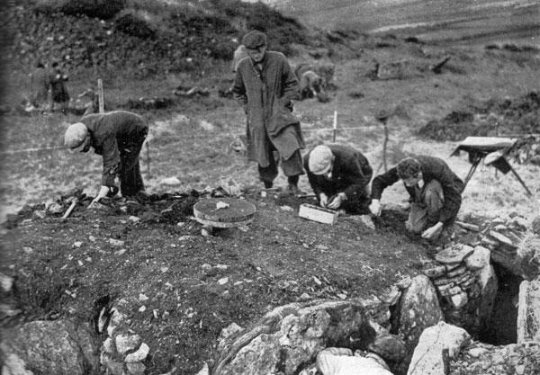
A rare photograph from Joseph Raftery's excavation at Cairn H, with Cairn L in the background, in 1943.
The monuments have not been excavated in recent times, the last major works being undertaken in 1943, when Cairn H was excavated by Joseph Raftery of the National Museum. Raftery found a large collection of carved pieces of cattle bone which dated from the Iron age, and this led him to conclude that Cairn H was of a much later date than the other monuments. Mounds of excavation spoil from 1943 can still be seen near Cairn H.
Little research took place after Raftery's excavations, until the late 1970's when interest in Loughcrew prompted a team of Japanese researchers to conduct a survey of the archaeology and art. In 1978 and 1979 the monuments were measured, surveyed and recorded, and the finds from Conwell's and Raftery's excavations were analysed. Rubbings were made of the major engraved stones, and the report was published in Japan. This important document was republished in 2011.
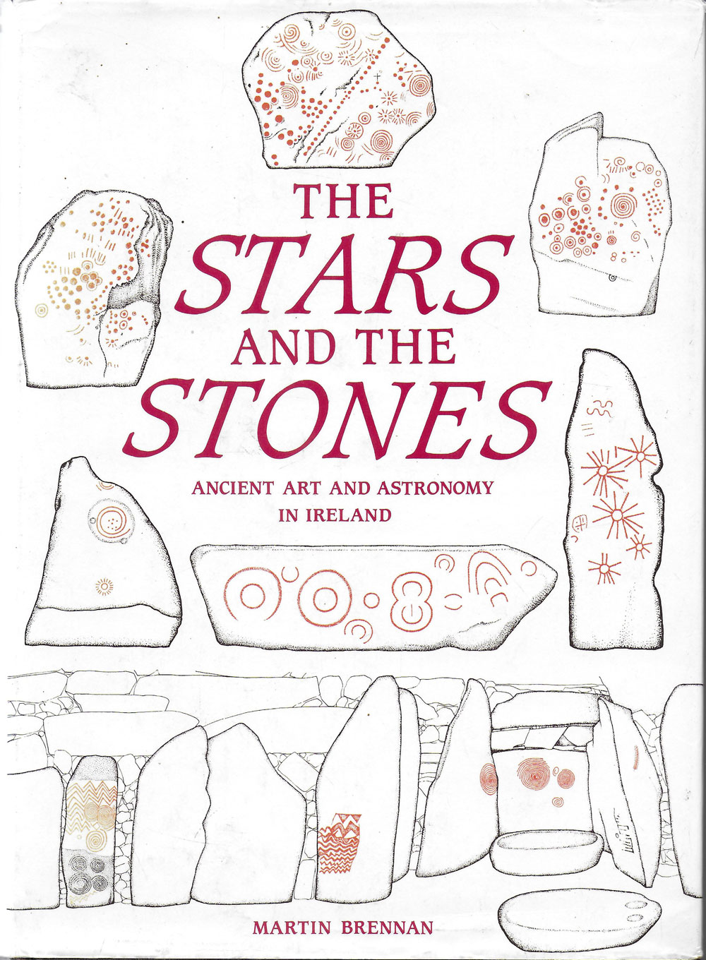
The Stars and the Stones published by Martin Brennan in 1983. I can safely say this book changed the course of my life, and I can still clearly remember the eureka moment I experienced when I first opened it.
In 1980, as mentioned above, researchers Martin Brennan and Jack Roberts made a number of important discoveries at Loughcrew, which were published in Brennan's 1983 book, The Stars and the Stones. In 1981 Irish archaeologist Elizabeth Shee Twohig surveyed and recorded art the engraved art at Loughcrew, which was published in her book, The Megalithic Art of Western Europe. Jean McMann also undertook a study of Loughcrew which resulted in the guidebook, Loughcrew: The Cairns. McMann also published a paper titled Forms of power: dimensions of an Irish megalithic landscape, in the journal Antiquity in 1994.
Further research has seen the discovery of a cursus and the identification of several more engraved stones in the townland of Ballinvalley just north of the Loughcrew cairns. Elizabeth Shee Twohig has discovered many more examples of open air carvings on erratic boulders around the hills, making Loughcrew currently the only major site where passage-grave art and the open air rock art have been found to coexist. Rock art is usually considered to be later than the neolithic and may indicate widespread bronze age reuse of this most sacred of landscapes.
The beautiful Loughcrew landscape: the view west to the collection of monuments on Carnebane West and Cairn M on Carrigbreac from Cairn P, one of the smaller and fairly ruinous passage-graves on the west slopes of Carnbane.
Loughcrew... ‘Cairns must be added to UNESCO’s World Heritage sites list’
VIEW FROM AFAR - ROBIN EDGAR, RESEARCHER, MONTREAL, CANADA
Robin Edgar, who is based in Montreal, Canada, has been researching how eclipses influenced ancient humanity's religious beliefs for many years and says the Equinox Stone in Loughcrew represents some of the oldest known representations of solar eclipses. He wants to see Loughcrew added to the UNESCO list of World Heritage sites: -
"I've been concerned about the deterioration and neglect of the Neolithic rock art in Loughcrew's Cairn T for several years. 'The Equinox Stone', and other Loughcrew rock art, displays some of the oldest representations of solar eclipses I know of. I've been researching how eclipses influenced ancient humanity's religious beliefs and symbolism since noticing the similarity of a total solar eclipse to the pupil and iris of an 'eye of God' in May 1992.
"I identified the rayed sun symbols, indeed 'compound eye-sun symbols', carved into Dowth's 'Stone of the Seven Suns' as accurate depictions of a total solar eclipse in 1990's. In the early 2000s, Paul Griffin independently identified overlapping concentric circles on an orthostat in Loughcrew's Cairn L as a depiction of a partial solar eclipse that he believed to be the 3,340 solar eclipses, which was a total eclipse to the south of Loughcrew. It was total above Knockroe and Stonehenge.
"I believe the flower-like symbols on Loughcrew's 'Equinox Stone' are inspired by the flower-like appearance of most total solar eclipses. There is also a solar cross symbol, simple rayed sun symbols, and possible 'solar boat' symbols.
"I shared my concerns about the neglect of Loughcrew's Cairn T with Malcom Noonan TD in a Facebook comment on January 17th. He thanked me and asked me to send him an email so he may act on my concerns. I will be following-up, and I hope the Loughcrew cairns will be added to UNESCO's World Heritage sites list soon."
Description of the Loughcrew Cairns by National Monuments
The passage tomb cemetery often referred to as Loughcrew is dispersed between three of the summits of the east-northeast-west-southwest Slieve na Calliagh ridge. It escaped attention during the making of the 1836 edition of the OS 6-inch map, and almost the first notice occurs in 1864 when E. A. Conwell published an account of the cairns in the Proceedings of the Royal Irish Academy and in subsequent papers (1866, 1873, 1879). From the west the principal hilltops are known as Carnbane West, Carnbane East, also called Slieve na Calliagh, and Patrickstown.
In the folk tradition as recorded by John O’Donovan in the 1830s (Herity 2001, 38) the cairns were created when a witch, the Calliagh Bhéarra (Beara peninsula, Co. Cork) was performing a magic ritual by jumping eastwards from hilltop to hilltop, depositing stones from her apron. The leap from Patrickstown was too strenuous and she slipped and died on the hillside. She is reputed to be buried on the south side of that hill.
Conwell had been digging the cairns since 1863 with the support of J. L. W. Napper, a local landowner and savant who owned most of the land at Carnbane East and West, while Patrickstown was owned by E. Crofton Rotheram, also an antiquary. Conwell’s descriptions are invaluable and are still used, while his scheme for identifying the tombs by letter, sometimes with additional numbers, is still adhered to today. Apart from an article published in Scotland (Frazer 1892-3) with drawings by du Noyer, and inclusion in Borlase’s work on the dolmens of Ireland (1897) little attention seems to have been paid to the discoveries at the time.
A slab of engraved stone thought to be the lid of a stone cist dating from the bronze age, which was found in Ballinvalley near Loughcrew.
There were smaller excavations by Coffey (1897) and Rotheram (1895, 1897), and Morris (1930), misled by Conwell’s belief that the cemeteries might be part of the location of the great fair of Tailtean, speculated further along those lines. These various investigations have revealed the internal structures and the art of many of the tombs, and most of the artefacts recovered during them are now in the National Museum of Ireland.
Since the late nineteenth century there was little further notice of the cairns, apart from an investigation and restoration of Cairn H in 1943 by Joseph Raftery of the National Museum of Ireland and passing references in general prehistories, until Professor Herity’s work on Irish Passage Tombs (1974). This drew together the results of all the previous work, catalogued the artefacts recovered, and highlighted the tombs and the great wealth of prehistoric art they contain.
Since then they have hardly been out of the public eye, with academic studies (McMann 1991; Shee Twohig 1981) as well as popular guides (McMann 1993). Herity’s survey and Shee Twohig’s work on the art are the most comprehensive to date, and their records form the core of these descriptions. More recently attention has switched to theorising about the development of the tombs and the cemeteries (Sheridan 1985/6; Cooney 2000, 158-63), researching the solar events that can be observed at cairns on Patrickstown Hill (O’Sullivan et al. 2010) and Carnbane East (McCormick 2012), and recording the rock art that can be found on the lower slopes of the hills (Shee Twohig et al. 2010).
The cairns are distributed between the hilltops of Carnbane West in Loughcrew and Newtown townlands (14) together with at least three standing stones, on Carnbane East in Corstown townlnad (7) with a standing stone, and at Patrickstown (4). There are other cairns (6), a ring-barrow, and standing stones in the col between the first two hills. Today only the monuments at Carnbane East and Patricktown, which are all National Monuments, can be visited. In his first communication Conwell (1864, 47-8) stated that 21 cairns in Thomastown townland on the S side of Patrickstown Hill, of which (ME015-111----) is probably the last survivor, were being removed at that very time.