The history of investigation at Carrowkeel parallels, in microcosm, that of Irish archaeology, from the birth of the discipline to the present; the catalogue of work carried out at the site shows a transition from largely destructive archaeological techniques to a variety of non-invasive methods. Though we are still dependent on the 1911 excavation report for information about the monuments and finds, a number of significant discoveries have progressed research there in the last 20 years. That work is brought together for the first time here. Discoveries include two pieces of passage tomb art recently found within Cairn B, which will be discussed together with megalithic art from the wider complex at Heapstown cairn and from the Carrowmore complex to the north.
Carrowkeel was the last of the great megalithic sites in Ireland to recieve academic attention or to be excavated. The monuments are also notable for the lack of mythology or folklore attached to them, while the Caves of Keash to the west and the ridge of Moytura across Lough Arrow to the east, which are swathed in stories, legends and mythologies.
The great Sligo historian W. G. Wood-Martin merely mentioned the monuments on the summits of the Bricklieves in his History of Sligo. The Carrowkeel cairns were first recorded in modern times by the naturalist Robert Praeger, who took note of the monuments during his 1896 survey of the rare orchids growing on the mountains.
Macalister, Armstrong and Praeger Excavate at Carrowkeel
Praeger returned in 1911 with R. A. S. Macalister and E. C. R. Armstrong, when the trio, with some local hired labour to help with the heavy pitching of rocks, and they performed the first modern excavations at Carrowkeel. The excavations took place in three somewhat hurried digs, which to modern eyes look more like organised looting than a scientific undertaking. Macalister had worked in Palestine, where monuments were removed in their entirety by massive teams of hired labourers, and the focus was on the aquisition of artefacts, the collection of information being a secondary consideration.
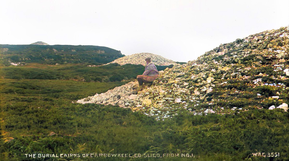
The eighteen days of excavation, during which seven monuments were opened and examined, yielded a large amount of finds and human remains. At the time, the monuments were considered to date to the bronze age, and indeed pottery dating from that period was found in Cairn K and Cairn O. Professor Alexander Macalister, who had recently taken up a position in Cambridge, took charge of some eighteen boxes of human remains, which he transported to England for examination.
Professor Macalister discovered the remains of at least thirty-one individuals, though the remains were so fragmentary he believed the total number might have been closer to sixty internments. The bones were a mixture of cremated (5.7 kg) and unburnt bones (9.7 kg), and a number of human skulls were included in the remains. Macalister believed the male burials averaged about five and a half feet tall, with the tallest specimen five feet nine inches. The women appeared to have averaged five feet one inch.
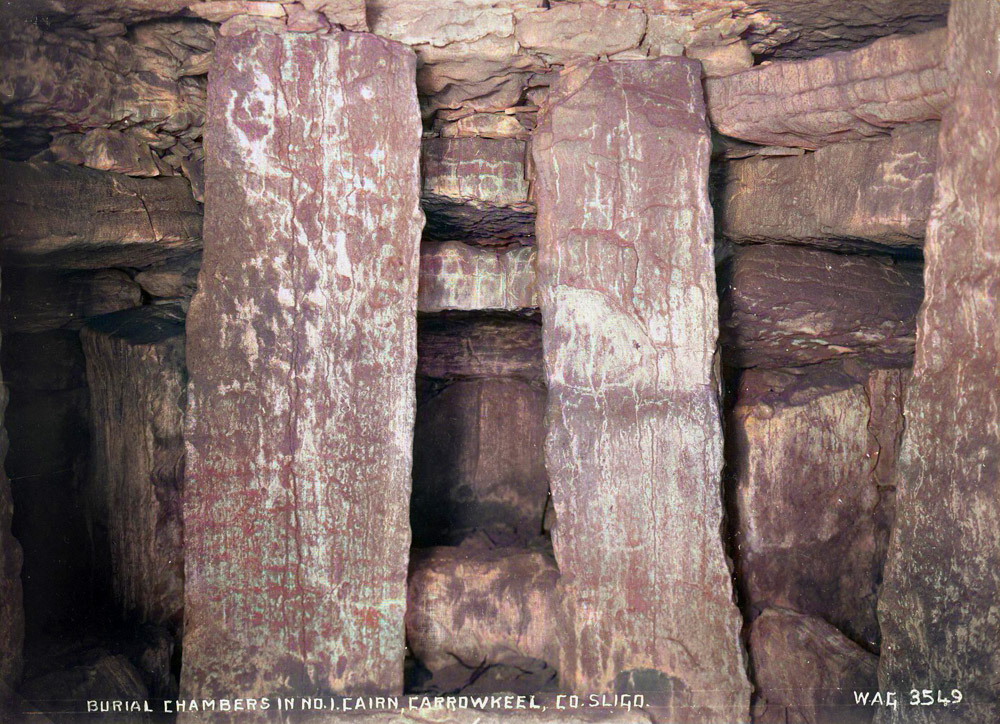
The suns rays shining through the roofbox in Cairn G at Carrowkeel.
There is no necessity to look too deeply at the 1911 excavations: the full report, which was published in 1912 and is available to read in its entirety or in sections on these webpages. The third round excavations were photographed by Belfast photographer William A. Green, and these valuable images show little Carrowkeel has changed in the intervening century.
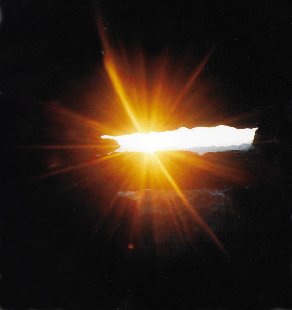
Michael Poynder
My own exposure to the wonders of Carrowkeel came in the late 1980's, when author Michael Poynder, who had just published his book, Pi in the Sky, gave a lecture to my art class in Galway.
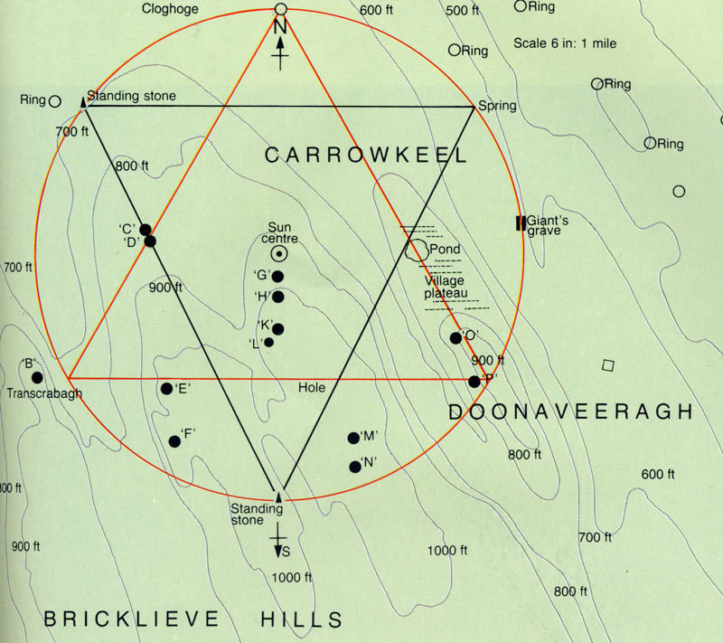
Michael Poynder's Carrowkeel Star.
Poynder's take on Carrowkeel was from a spiritual or new age perspective rather than an archaeological study. He believed the monuments to have been built by refugees from the lost kingdom of Atlantis, and that the monuments, which were constructed over fault lines running through the limestone terrain, were positioned in relation to underground springs and placed to mark conjunctions of the planets Saturn and Jupiter. He proposed a theory that the monuments were designed to represent an Earth Star, a geosidic construction designed to harness and focus earth energies on the chambers of the monuments to aid the fertility of the stone age tribes.
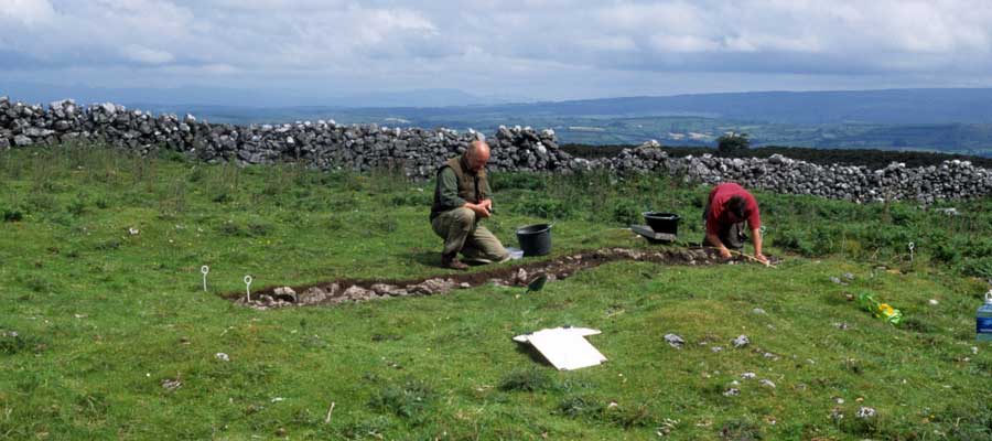
Stefan
Bergh and a student excavating a six by one meter trench across one of the
Doonaveeragh house sites in 2003.
Stefan Bergh
While many archaeologists and researchers mentioned Carrowkeel briefly, no major studies were undertaken until the mid 1990's, when Swedish archaeologist Stefan Bergh published his doctoral thesis, Landscape of the Monuments. Though this study primarily examined the Carrowmore and Cuil Iorra monuments, Bergh surveyed the monuments in the Bricklieve mountains and speculated on their relationship to the free-standing tertre style passage-graves at Carrowmore.
The Cuil Irra region on the west coast of Ireland is one of the richest areas of passage tombs in western Europe. The monuments range from small, simple, dolmens to complex monuments with gigantic cairns, and cover the timespan c. 4000-3000 BC. Landscape of the Monuments is the first modern, detailed account of this important group of monuments from a regional and spatial perspective, and includes a corpus of all monuments. The book focuses on a number of aspects relating to the location of the monuments in the landscape, and discusses the nature of Neolithic man's intentions to organise his physical and symbolic world. The great variation of monuments is discussed in terms of ritual and social complexity, and seen to reflect an ambition in Neolithic society to manipulate the way the social and physical landscape should be comprehended. The relation between the Cuil Irra monuments and the nearby passage tomb complex of Carrowkeel-Keshcorran is analysed, and the Cuil Irra region is furthermore seen in its wider context of the Irish passage tomb tradition.
Bergh excavated a trench through Cairn M at Carrowkeel in 1987, where he recovered a human tooth which was dated to the bronze age, and charcoal which had mid to late neolithic dates. In 2003 Bergh conducted further excavations within three of the neolithic house foundations on Doonaveeragh plateau. While these excavations seemed to indicate a late neolithic or early bronze age occupation of the 153 or so house foundations, a fine neolithic convex flint knife was discovered.
Sam Moore
Sam Moore, a native of Dublin, moved to Carrowkeel where he shared a house with the author, in 1995, and has been studying Carrowkeel and writing articles about the monuments, teaching archaeology, and leading guided tours ever since. Sam's special are of interest in Carrowkeel is the liminality of the monuments, the sense of being between two worlds. He took part in Stefan Bergh's excavations on Doonaveeragh plateau in 2003. Sam has published a number of articles on Carrowkeel, and participated in several teams who have furthered the understanding of the complexities of the Sligo neolithic.
Sam Moore displays a flint knife, freshly excavated from the trench in the background. This piece came from Antrim and firmly dates the site to the neolithic.
Alison Sheridan
Archaeologist Alison Sheridan, a specialist in passage-tombs, played what may seem a small, but certainly a crucial part in the history of research at Carrowkeel. In 2003, while conducting some research in Cambridge, Alison discovered a series of eighteen boxes labelled 'Carrowkeel', and concluded that these items and human remains pertained to Carrowkeel in County Sligo. as it turned out, these were the boxes removed by Professor Alexander Macalister, which he took back to Cambridge for examination in 1911 at the conclusion of the excavations led by his son, R. A. S. Macalister.
Ireland in the wider prehistoric world, 4300–1500 BC, a lecture by Dr Alison Sheridan, former Principal Archaeological Research Curator in the Department of Scottish History and Archaeology, National Museums Scotland.
After Alexander Macalister's death in 1919, the boxes were stored away and forgotton about for eighty years until Alison Sheridan rediscovered and recognised them in 2003. Alison, who bumped into Sam Moore at a conference in 2011, a century after Macalister's excavations, told Sam about her discovery, which led to a new and exciting phase in the research and understanding of Carrowkeel.
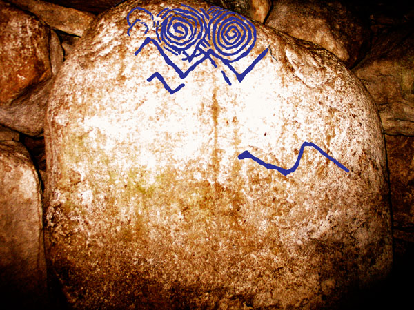
Robert Hensey
In 2009, Robert Hensey, an OPW tour guide working at the Carrowmore megalithic complex, discovered a piece of neolithic art carved on a chamber stone in Cairn B at Carrowkeel. This brought the total number of megalithic carvings in County Sligo up to three. I had discovered carvings on a kerbstone at Heapstown cairn around 1997, while Michael Roberts and Patricia Mulligan, two guides working in Carrowmore noticed a carving on the edge of the capstone covering the chamber of Listoghil, the large dolmen at the centre of Carrowmore.
Megalithic art, recently discovered in Cairn B at Carrowkeel.
Ancient DNA and Carrowkeel
The rediscovery of the human remains which had been exhumed in Carrowkeel during the 1911 excavations led to a new and exciting phase in the Carrowkeel story. Lara Cassidy and Dan Bradley of trinity College had made history when they sequenced the Ancient DNA genomes of the Ballinahatty Woman, a neolithic woman buried in a strange megalithic chamber close to the Giant's Ring, an enormous henge containing an early passage-tomb close to Belfast.
This event has revolutionised Irish archaeology. Lara was able to demonstrate that the Ballinahatty Woman could trace her ancestry back to ancient Anatolia in south western Turkey. She was descended from a group of early neolithic farmers who were among the first humans to domesticate cattle and crops. These colonists had left Anatolia, possibly due to competition and overcrowding, migrated by ship westwards through the Mediterranean, bringing livestock and crop seeds with them. They had passed through Sardinia, around the Iberian peninsula where they built many monuments, and settled in large numbers in the Carnac region of Brittany where a great neolithic culture emerged.
In the case of Carrowkeel, the re-analysis of the assemblage has highlighted the high level of complexity and diversity of the funerary rites, which perhaps was not fully recognized previously. This complexity is particularly evident in the manner in which the bodies of the deceased were processed and handled after death. This treatment included cremation, dismemberment, and possibly intentional fragmentation of remains. The evidence of postmortem body processing at Carrowkeel is not unique from a European perspective, but it remains a rarely reported occurrence from the bio archaeological record from Ireland. This discovery provides another key to understanding the social signigcance of this fascinating cultural and ritual landscape for the people who constructed and used it over several centuries, five thousand years ago.