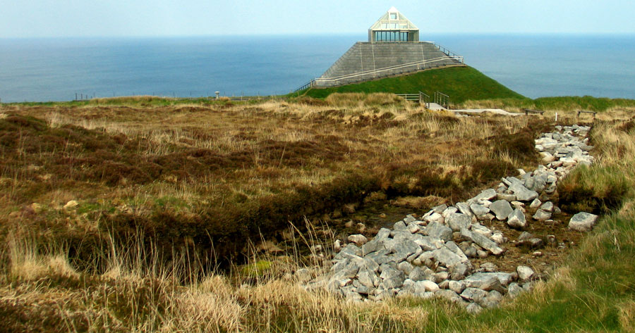
The pyramid-shaped visitor centre at the Ceide Fields, with one of the tumbled field walls to the right.
The Céide Fields
Caulfield is convinced that the fields were intended for the management of herds of cattle which would have thrived on the pasture within the enclosures. The growing season for grass in Mayo at present is about nine to ten months depending on winter temperatures and in the slightly warmer conditions of 3,000-2,000 BC, it may well have been even longer. Haymaking for winter fodder was unnecessary. Allowing for lesser yields than in modern herds and assuming that the Neolithic cattle in Ireland were somewaht larger than had been thought, Caulfield thought that the Céide Fields could have supported about five family farms of about 25-30 hectares, each hectare producing about 100kg of beef per annum. Based on figures for the cattle of the Late Neolithic settlement at Newgrange, he has postulated that herds of fifty animals grazing about 30 hectares may have been the norm. The harvest would have been the three-year old beasts and the older cows past the productive stage.
The slaughter of a beast, however, would have presented problems. If, say, an animal of about 500kg was killed, about 300kg of meat would be produced and unless the beef could be preserved by drying, salting or smoking, the neighbours would have to have co-operated in the consumption of the kill and in the rational staggering of the slaughter times to ensure a continious supply. Such co-operation is implicit in the walls and organised landscape. The harvest from the early cattle economy, if the figures are right, would in Caulfield's opinion have supported two hundred to two hundred and fifty families in the 50 sq km which would have been required to feed one equivalent hunter-gatherer family. On present evidence, the creation of the field system seems to date to the final stages of the Neolithic. They were extensively used in the Bronze Age and we shall return to this later.
Reading the Irish Landscape, Frank Mitchell and Michael Ryan, 1986.
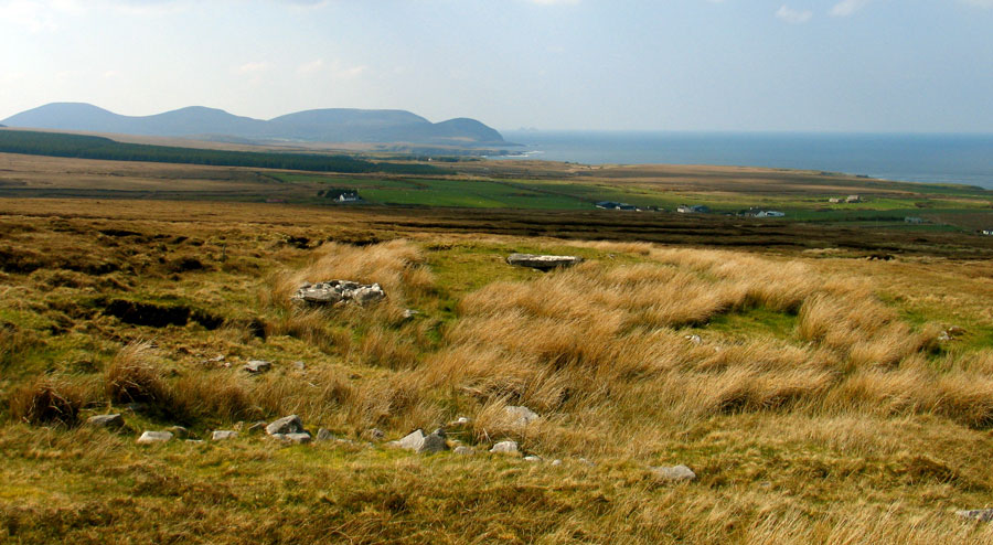
The Céide Fields is an extensive and somewhat contraversial collection of monuments and field systems found where the northern slopes of Céide hill slant down through the townlands of Behy and Glenulra to a steep cliff-edge along the coast of North Mayo. The infamous tumbled Neolithic stone walls—or linear Celtic field clearance cairns depending on your point of view—slope down the north-facing hillside overlooking Sligo Bay and the Atlantic ocean.
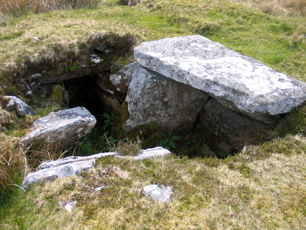
The area is home to a cluster of impressive Neolithic court-cairns and a pair of dolmens, probably built in the middle of the fourth millennium BC. The Neolithic monuments in the immediate area include the well-preserved example of a transeptal court tomb at Behy close to the visitor centre, the most westerly of the eleven megaliths in the area. Further to the east is the central court tomb at Ballyglass, excavated by O'Nuaillain in 1971, and further again to the east, the fine example of a court cairn at Rathlackan, which was excavated by Gretta Byrne, manager of the visitor centre.
Céide Fields - History on our doorstep—a video interview with Gretta Byrne.
The extensive set of field systems, tumbled stone walls which were covered by bog at some stage in prehistory form the main attraction, and the site is interpreted for the public through the pyramid-shaped OPW visitor centre which opened to the public in 1993. The field walls are promoted and marketed as dating from the Neolithic and as being contemporary with the court-tombs, a view which has generally been acccepted by the archaeological community and is the consistant view in the majority of published references to the complex. However, not all are convinced by the claimed Neolithic dates for the walls, and a challenge was made in 2017 by Dr. Andrew Whitefield. Upon reviewing all the available published dating information and data, Whitefield remains convinced that they date to the late Bronze Age, and are a typical example of the Celtic field systems found throughout western Europe.
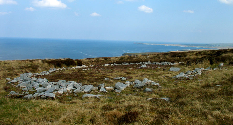
The court cairn at Behy, beside the Ceide Fields. The monument, which was excavated in the 1960's, has been reclaimed by the bog and can be hard to locate. This site has fantastic views out across the Atlantic. The Stags of Broadhaven, two pyramidal rocks jutting out of the ocean are visible on the horizon.
The Behy Excavations
The area currently known as the Céide Fields contains one of the densest concentrations of Neolithic court tombs found anywhere in Ireland, with some thirty examples of this early kind of monument found in the immediate region. However, despite fifty years of research with very little informative publication – and what we do have tends to use a language of uncertainty and ambiguity – do we have a plausible link or connection between the neolithic monuments and the field walls?
The chamber of Behy court cairn. This fine monument was excavated in the 1960's, but has since largely been reclaimed by the bog.
The survey and excavation work in north Mayo at the Céide Fields suggests that court tombs were intimately linked with the patchwork of fields and settlement in the local landscape
Neolithic Britian and Ireland, Caroline Malone, 2001.
The majority of modern archaeology books tend to assert that the stone walls and the court tombs are contemporary, but is there evidence to support this? The most important part of this story may well be the events at the very beginning, the excavations at Behy. The court tomb at Behy lies hidden in the bog some 300 meters from the visitor centre. The monument is on private property and is not included in a visit to the Céide Fields: most people simply do not know it is there. The monument was known for some time by locals who had discovered it while cutting turf; it was known as "The Roomeens" or little rooms and had been used as a still house where poteen was distilled.
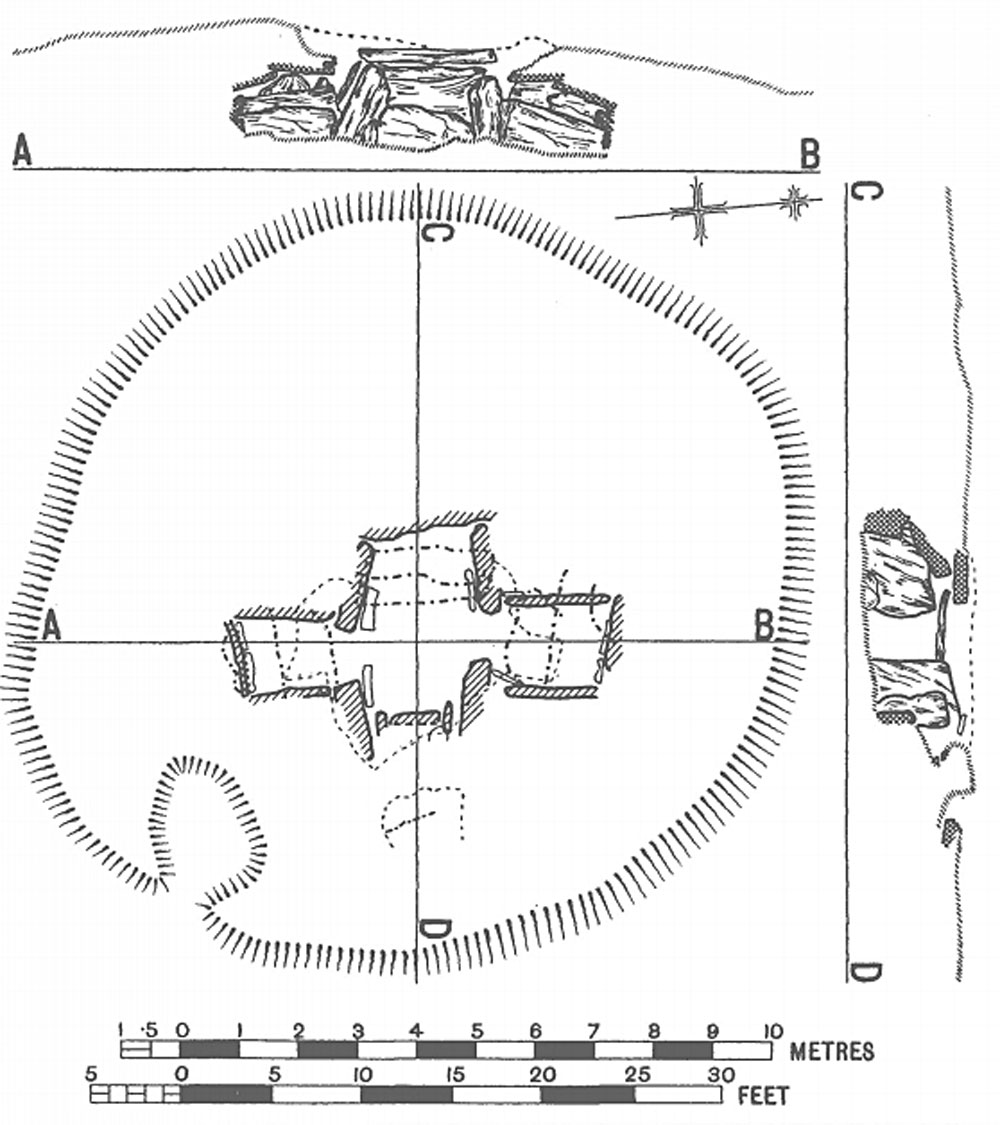
The monument was the subject of a report published in 1952 by Seán Ó Nualláin and Ruaidhri de Valéra, who thought the megalithic chamber to be the only example of a passage-grave discovered so far in County Mayo. They revised their opinion after a second visit in 1959, and decided to excavate the site. Seán Ó Nualláin and Ruaidhri de Valéra along with Michael Herity, returned to dig the monument in 1963 and 1964, using workmen from local villages for labor. The excavations revealed a court cairn almost 30 meters long, aligned east to west, with a chamber and court in the east side.
A plan of the chamber of the monument at Behy from the 1952 report. The chamber was interpreted at the time as a passage-grave, the only example then known in County Mayo.
The cairn was constructed using large blocks of local limestone, with a kerb and court made from monumental dry-stone walling. The court gave access to an inner chamber somewhat cruciform in shape, which the monument was originally thought to be a passage grave. Cruicially, a crudely constructed field wall was found at the north side of the cairn; this feature leads off north for several meters before dividing, one section swinging off to join the field system, the other looping around and returning to the cairn to create a D shaped enclosure. The excavators noted that the cairn was certainly older than the wall, which indeed was constructed using material quarried from the neolithic monument, a point alluded to by Séamus Caulfield in his 2011 report:
Over the collapsed facade on the left side of the court a stratigraphically later rubble stone wall overlay the cairn collapse and ran eastwards towards the uncut bog.
De Valéra and Ó Nualláin’s single minded focus on the megalithic tomb saw the wall on the collapsed cairn as obviously stratigraphically later and separated possibly by millennia from their focus of study.
Séamus Caulfield, Neolithic and Bronze Age Landscapes of North Mayo: Report 2011
This, then is the first archaeological investigation conducted in this region, and the excavators concluded that the wall was younger, possibly by several millenia, than the megalithic monument it crossed.
A photo from the second excavation season at Behy in 1964, showing the court and the entrance to the chamber.
The Discovery of the Pre-bog Field Walls
During the 1930's, as locals were cutting turf from the extensive boglands in the region, they often noted lines and alignments of what appeared to be the tumbled remains of pre-bog stone walls. Many reported their findings to Patrick Cauldfield, the National school teacher at Belderrig, who in turn sent an account of these mysterious structures to Adolf Mahr in the National Museum in Dublin in 1934. However, pre-bog walls in rurual Mayo did not excite much interest, and nothing was done at the time. Later the teacher's son who had also trained as a teacher, Seamus Caulfield, studied archaeology, determined to investigate the structures under the bog at Behy and Glenulra. In 1963 and again in 1964 he joined the excavation team at Behy, which included students from UCD.
In an article, Prehistoric Fields in Ireland, published in 1971, Michael Herity, who was one of the excavators at Behy in 1963 and 1964, comments:
In one place the builders had actually robbed the cairn for walling material. The walls, like the tomb, had been built on the old soil of the hillside, both being later covered over by the growth of blanket peat. It was possible to trace the walls in adjacent bog cuttings, and the field system enclosed by them could be seen to extend up the hillside from the tomb to about six hundred feet above sea level and downwards as far as the coast.
In the same year, a similar pre-bog field enclosure on the south-facing slope of a low knoll in Carrownaglogh, east of the Moy and also in County Mayo, was reported to the National Museum by the landowner, Mr Thomas Toher, who had found a flint slug-knife of Neolithic or Early Bronze Age type among the stones of one of the walls.
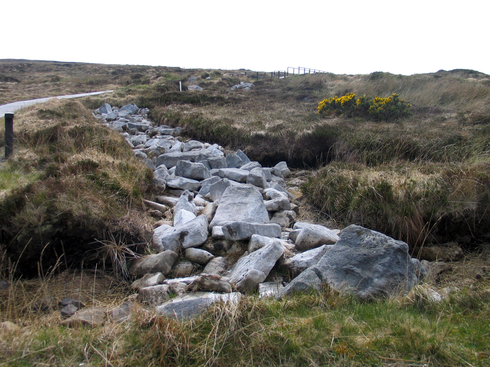
An excavated section of a collapsed wall at Céide. Recently academics have questioned the age of the walls; such structures are commonly found in the Iron age.
Herity continues:
The walls in common with the tombs are durable structures and, where modem turf-cutting has removed significant amounts of covering peat, the fields they enclose can be readily enough recognized. It was realized that an unusual new kind of prehistoric evidence in the shape of fields could thus be made available in Ireland to augment the kinds of habitational evidence already being investigated. This line of research also offered a new means of finding prehistoric homesteads.
Herity, who was interested in finding habitation sites approached Caulfield, and the pair initiated a survey, sending out letters to farmers in the west of Ireland to find out if any had discovered pre-bog walls while cutting turf:
The Man who found Céide, an RTE 1 documentary Programme from 1994, the year the Céide Fields Visitor Centre opened.
It seemed that the best initial results could be obtained by a questionnaire survey aimed at reaching the turf-cutters themselves. At this stage the writer invited Mr Seamas Caulfield to collaborate with him in the work. The questionnaire sent out was modelled on those of the Irish Folklore Commission and was posted in the spring of 1966 to 250 local informants scattered through the country. At the same time it was published in the journal of the Irish National Teachers' Organization. Of 150 reports returned, twelve gave promising indications of the kind of fences sought. On investigation, six of the twelve yielded evidence of pre-bog field systems in counties Kerry, Clare and Sligo.
Field survey in likely areas by the writer and Mr Caulfield has since doubled the total known. Fences have now been recognized at about thirty locations in the west and north of the country from Kerry to Antrim, the only significant lacuna being in Galway and north Clare. The enclosed fields averaging three to four acres in extent are laid out usually on sloping ground; some very small enclosures a half-acre or less in extent may well be the tillage-plots of the system. Long straight stretches of wall extending in one case more than a mile in length probably indicate divisions between family holdings.
Prehistoric Fields in Ireland, Michael Herity, 1971.
The Largest Neolithic Monument in the World
Seamus Caulfield continued his research, conducting surveys in the boglands by plunging long steel rods in to the peat to locate unexcavated walls. Though the main concentration of regular coaxial field systems are found in the area around the Behy monument close to the visitor centre, Caulfield discovered that they stretch for several kilometers to the east and west. Walls and monuments have been found on the hill of Rathlackan some twelve kilometers east of the Céide visitor centre, while field walls exhibiting plough marks and a dwelling site, all dating to the Bronze Age were found at Belderrig to the west. Late mesolithic activity was also discovered close to the sea at Belderrig.
Ordinary stone-walls are also found on this pre-bog land surface. These walls, similar to the modern stone walls which are such a characteristic feature of the Irish landscape, are revealed whenen present-day turf-cutting for fuel, strips away the bog. Unlike the tombs or well-known prehistoric objects which can readily be identified as ancient, these walls are given an antiquity solely because of their postion below the bog. It is these stone walls, enclosing the
fields of the Bronze Age and Stone Age farmers which are being studied at present.
Agriculture and settlement in ancient Mayo, Seamus Caulfield,
An excavated section of a collapsed wall within the Céide Fields complex. The walls, which would have been too low to restrain cattle, lack gates or entrances which would have been essential for the movement of stock. There are no springs or streams to be found within the Céide fields, which would have made settlement or stock rearing challenging in this landscape.
The dating of the Neolithic activity at Céide Fields has been seen as problematic but a detailed pollen analytical study and associated radiocarbon dates centered on a long core taken from a small peat-filled basin within the area of the field walls and a programme of dating ancient pine tree stumps in the blanket bog over the mineral soil on which the walls and other structures were built has demonstrated that there was a farming phase lasting from around 3,700 to 3,200 BC.
Landscapes of Neolithic Ireland, Gabriel Cooney, 2,000.
The picture presented to the visitor today is that neolithic colonists, who arrived here in great numbers in the years following 4,000 BC, cleared and farmed the land here, planting crops such
as barley and emmer wheat, keeping cattle and sheep as their livestock. The massive undertaking that saw the creation of the field system is envisaged as dating from the same time period as the court cairns in the area. As Frank Mitchell mentions in the quote at the top of the page, "Caulfield is convinced that the fields were intended for the management of herds of cattle which would have thrived on the pasture within the enclosures."
The field system does vary across the North Mayo coastline, but it is the regular ladder patterns of Céide that dominate the imagination.
Neolithic and Bronze Age Landscapes of North Mayo, Gretta Byrne, 2009.
This raises several immediate questions when one looks at the remaining wall structures. No remains of cattle have been yet discovered at the site. The remains of the walls are simply too low to have restrained cattle in any practical way. The walls also contain no gaps: entry and exit gates would have been essential for the management of cattle on the scale envisaged by Caulfield. And finally, what did these herds of cattle drink? There is no easy access to fresh water, so essential to rearing livestock, in the area now known as the Céide Fields that so "dominate the imagination.".
Ceide Fields as a focal point in North Mayo is an ideal new product for environmental tourism development. The Ceide Fields focus will also be the hub from which the well-briefed visitors may radiate outwards to visit and appreciate the multifaceted environment of North Mayo.
Seamus Caulfield & M. J. Downes
Looking
west across Cairn C, the Leprachaun's House, a passage grave at the Carrowkeel complex in County Sligo. The monument is crossed by a stone wall which divides the townlands of Cloghogue from Carrowkeel. If we were to follow the logic used in Mayo, this wall, dating from around 1837, would be classed as Neolithic!
Dating disagreements
Archaeological research has shown that the fields cover an area of at least 2.500 acres or four square miles. Ceide Fields is thus the most extensive Stone Age monument in the world. It is also the oldest intact field-system in the world. The intact Stone Age landscape of regular fields, dwelling areas and megalithic tombs has lain hidden and preserved since the bog grew over it almost 5000 years ago.
Seamus Caulfield & M. J. Downes
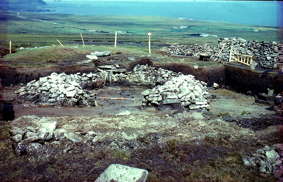
Sadly, there are no convincing dates to be found in the published research which prove that the pre-bog walls are neolithic, or that they were intended to contain "herds of cattle which would have thrived on the pasture within the enclosures." In 1969 Caulfield excavated sections of wall close to Behy, discovering in the process the circular enclosure at Glenulra, within the visitor centre complex and 150 meters east of the Behy monument. He excavated this enclosure in 1970 and 1971, discovering the post holes of an unidentified structure. Some finds of Neolithic pottery and a spread of charcoal, which was dated were also discovered.
The stone walls at Céide and Belderrig appear to have been well built, although today they survive in a semi-collapsed state. By comparison with more recent field walls, there is a certain blandness about them in the sense that they seem to lack access gaps of the type that are standard in more recent field boundaries.
Antiquities of Rural Ireland, Muiris O'Sullivan, 2017
Though the charcoal was dated to the latter half of the fourth millenium BC, use of charcoal for dating monuments is an obselete practice in archaeology particuarly after some of the extremely early dates discovered by Burenhult at Carrowmore. The Carrowmore dolmens were re-dated in 2011 by Bergh and Hensey, using samples from red deer antler included with the cremations, to present a much more logical sequence of events. To say the least, the charcoal sample from Glenulra may have been the product of an accident such as a forest fire, rather than man made.
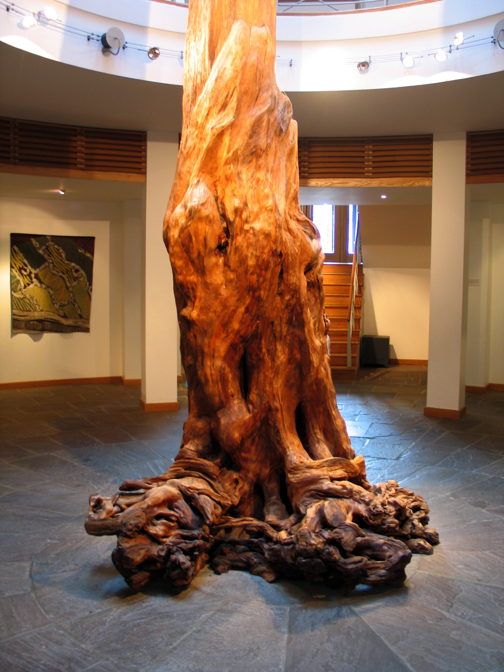
The huge example of a bog pine tree trunk on display at the centre of the foyer in the Céide Fields Visitor Centre. This specimen came from the Caulfield family home in Belderrig.
The Walls Become Neolithic
The field walls or enclosures were not claimed to be Neolithic in writing until the late 1970's, and the means used to secure these dates was a programme of taking dates from pine trees and stumps found throughout the bog.
At many locations within this blanket bog the stumps of ancient pines (Pinus sylvestris) are found in situ. The pine roots in most cases are either on the surface of the mineral soil under the peat or at an indeterminate level in the peat itself. The age of the trees in the bog overlying Céide Fields is therefore of great significance for the dating of the fields, as the trees must be younger than the bog in which they are growing, which in turn must be younger than the field system beneath it.
Séamas Caulfield, 1998.
Archaeologists clash over dating of Céide Fields complex: source.
Professor O’Connell continued: “The substantial and multi-disciplinary body of evidence now available demonstrates, beyond all reasonable doubt, that the pre-bog field system at Céide Fields pertains to the Neolithic and indeed the earlier part of the Neolithic as known from Ireland, Britain and much of north-western Europe including Scandinavia, a view that is also shared by most archaeologists and other palaeoecologists.”
Get Away From The Wall, a surreal song about a wall by Ivor Cutler
In 2017 the European Journal of Archaeology published a paper by Dr. Andrew Whitefield who claimed that having carried out "a critical analsys of the available chronological data" he proved that the Céide Fields dated to the later Bronze Age and that our dating of the fields to the Neolithic was due to "an artefact of the research method". Far from studying the available data, Whitefield reproduced a small corner of the Céide Fields plan, considered just three of the fifteen pine tree dates and claimed we used the in situ pine trees growing in the bog to provide termin post quo for what was beneath them. The two later Bronze Age dates on which he places such emphasis, did not, as he claimed, allow the archaeologist excavator to date the construction of the walls to the late Bronze Age. The suggested later Bronze Age date proposed by the palaeobotanists on the basis of supposed similarity between two pollen spectra from the mineral soil under and beside a wall. The paper contains an extraordinary number of other statements akin to those above which are simply not true. A comprehensive rebuttal is being prepared.
Céide Fields and Belderrig Valley. Eighty Four years of Research, Séamus Caulfield, 2018.
Several court-cairns are scattered
across the Céide Fields. For many years, these were considered to be the oldest type
of megalithic monument in Ireland, but more recent research on the Sligo passage-graves has shown that
the courts may be contemporary or slightly younger than the passage-graves. The causewayed enclosure at Magheraboy in Sligo is currently the oldest dated neolithic monument in Ireland.
The court cairn at Behy, beside the Ceide Fields. The monument, which was excavated in the 1960's, has been reclaimed by the bog and can be hard to locate. This site has fantastic views out across the Atlantic. The Stags of Broadhaven, two pyramidal rocks jutting out of the ocean are visible on the horizon.
The Céide Celtic Fields
The walls
that brought the Céide Fields to light were preserved by the growth
of bog across the prehistoric landscape. As the climate changed, about
3,500 years ago the land became wetter and harder to farm, until the bog
took hold and began to grow. Over the intervening span of time, plant
and moss fibers decomposing built up the layers of peat, smothering the
stone walls. The fields were rediscovered by modern farmers cutting turf,
the traditional fuel in the west of Ireland. For years they had been coming
across tumbled stone walls and sometimes quernstones. Archeologists in
the area developed a technique of probing the bogs withlong metal probing rods,
which enabeled them to map the wall systems without excavating them.
A section of exposed wall at Ceide.
The Visitor Centre
There is still plenty of work to be done. Simple questions such as who were the inhabitants of the Céide Fields have not been answered yet. They could have been Celtic, but the Iron Age warrior Celts at the dawn of history in the final centuries BC had nothing to do with the peaceful farmers of north Mayo who go back at least tWice as far, to 3000 years BC.
But then again, if the spread of the Indo-European languages, including Celtic languages, can be traced back much earlier that than has been generally accepted up to now, a theory put forward br Professor Renfrew of Cambndge, then
these first farmers could have been Celts.
A large
visitor centre was built at Ceide in 1994, which provides a good base
from which to visit the windswept landscape. It is perched on the cliffs,
located outside the north edge of a field. The centre is built in the
form of a pyramid, with bog growing up the sides, and a glass viewing
top, so is easy enough to find.
"The argument that such centres are an intrusion between individual appreciation and the site itself is invalid. It's like safing that staging Hamlet is an intrusion on the text.
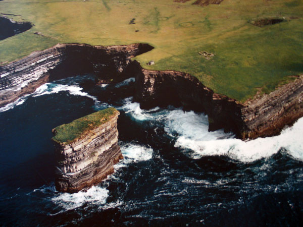
Downpatrick Head, the place where, according to legend St Patrick banished all the snakes from Ireland. The sea stack, Dun Briste (the Broken Fort) has an ancient habitation site on its summit. The foundations of a house and two barrows can be seen at the top of the picture.
Another famous monument - at least to archaeologists - is the Ballyglass court
cairn. When this monument was excavated, the site of a rectangular house
was discovered beneath the monument. A reconstruction of this dwelling can
be viewed in the visitor centre.
A large circular enclosure at Glenulra within the Ceide Fields in County Mayo. Seamus Caulfield, who excavated the site in 1970 has suggested that this feature may have been used as a pen for cows with young calves, or even possibly a house site. However, no cattle remains from ancient times have yet been discovered at Céide.