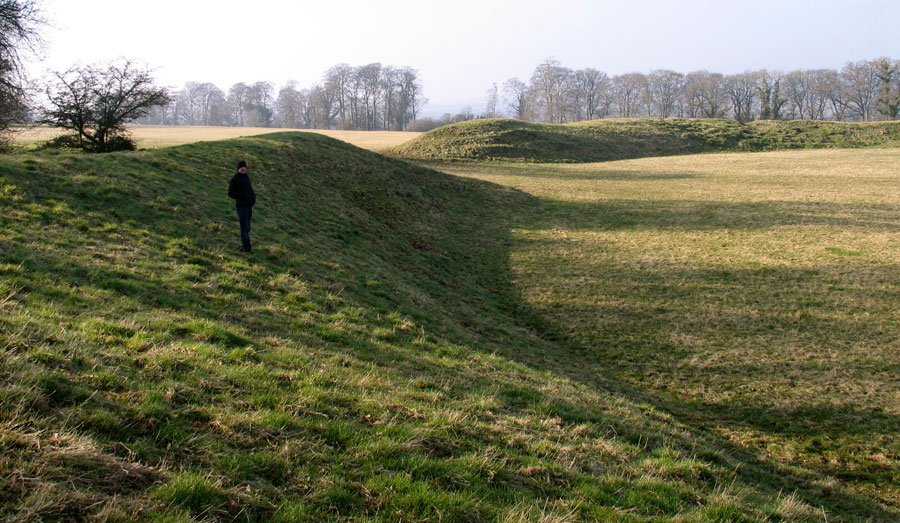
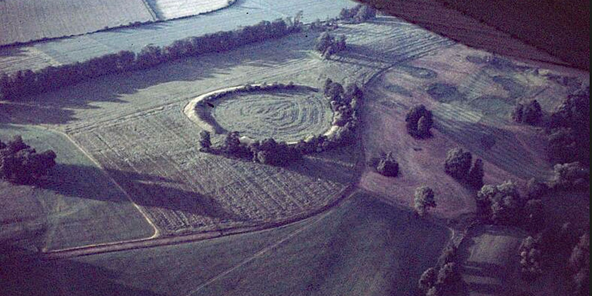
The massive neolithic henge near Dowth in the Boyne valley; this huge oval ceremonial enclosure measures 175 x 165 meters, with an earthen bank 20 meters wide.
The Great Neolithic Henge at Dowth.
This incredible monument dating to the later neolithic, is one of the largest henges on the island of Ireland, along with the Giant's Ring at Ballynahatty outside Belfast and Rath Maeve at Tara. The Dowth enclosure, which is titled Site Q, is oval shaped, with a massive bank some 20 meters in width surrounding an egg-shaped central area measuring 165 by 175 meters. The bank is about 5 meters high, and there are two openings on opposite sides, one to the south west and another to the north east.
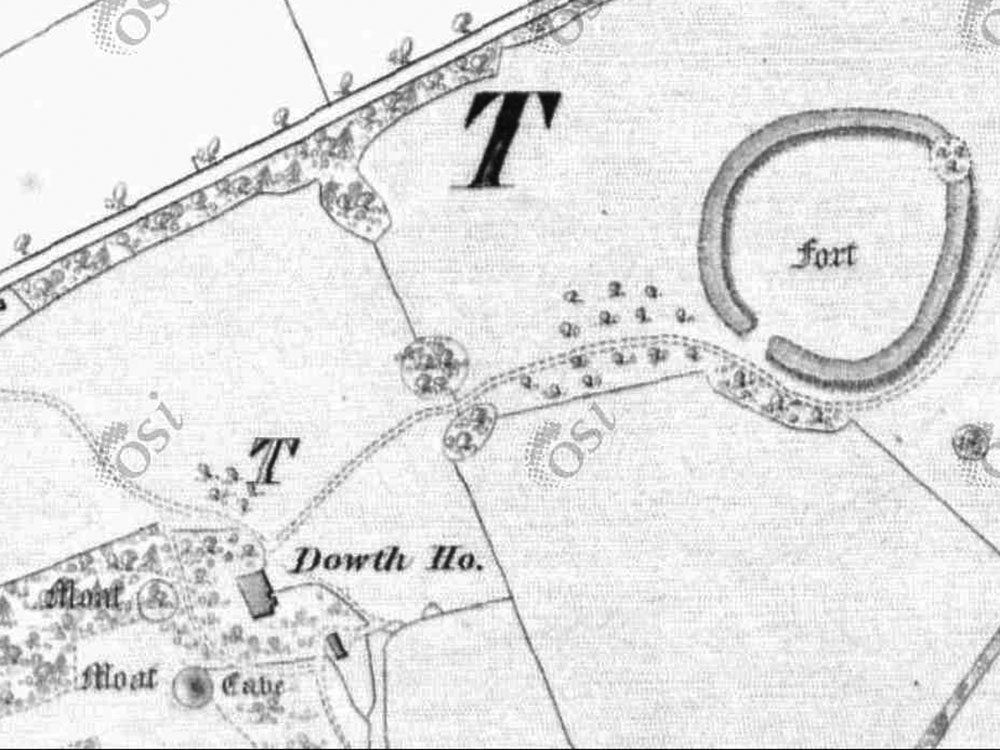
Dowth Hall and monumens on the 1837 Ordnance Survey map.
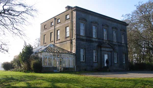
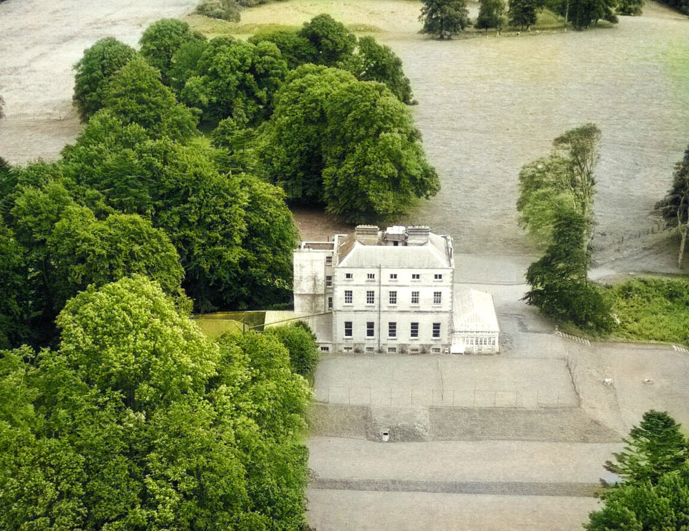
The openings in the bank may be astronomically aligned, as the axis is of the monument is alongside the midsummer sunrise, midwinter sunset line, though researchers think the south west opening is more modern. The henge is located on the grounds of Dowth Hall, a Georgian Manor House which was built by the Netterville Family in 1760. There are two small neolithic passage-graves in the garden behind the house.
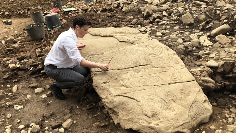
Excavations in 2018 uncovered a huge and previously unknown passage grave under the terrace of the Hall. This newly discovered monument is about 40 meters in diameter and several carved kerbstones were also found.
The tomb excavated by Clíodhna Ní Lionáin and her team has suffered significant damage over the years: stone from the cairn is believed to have been used in the construction of Dowth Hall, a servants tunnel cuts through one side of the site, and many orthostats – the slabs of stone with make up the walls of the interior – are not in their original position. Source.
The estate and monuments at Dowth were sold after the members of the Pigeon family died out. A company called Devenish - named after the holy island north of Enniskillen - purchased the property and proceeded to renovate the delapidated buildings at Dowth Hall and the Netterville Institute.
The land at Dowth is a significant estate of approximately 223 Hectares (552 acres) including two country houses (Dowth Hall and Netterville Manor) and an extensive demesne laid out along the River Boyne and valley in County Meath.
A recent biodiversity survey of the lands reported 54 species of birds, five of which are of high conservation concern, including a population of red-listed and highly threatened native Grey Partridge, which is supported by a captive breeding programme on site. Eleven species of butterfly, eight species of bat and seven species of bee have been recorded here. Foxes, badger, rabbits, hares, shrews and red deer are also present.
The cultural heritage of Dowth spans a wide time-frame, from early prehistory, through the medieval period, up to the 18th and 19th century and right up to the modern era. It features Neolithic monuments built over a period of 4,000-6,000 years ago by Ireland’s first farming communities. In 2017, the remains of a large passage tomb, which was more than 5000 years old, was discovered under Dowth Hall.
Excavations at Dowth Hall in 2018 uncovered a huge and previously unknown passage-grave under the terrace of the Georgian building. This newly discovered monument is about 40 meters in diameter and several carved kerbstones were also excavated.
Dowth Hall. Excavations in 2018 uncovered a huge and previously unknown passage grave under the terrace of the Hall. This newly discovered monument is about 40 meters in diameter and several carved kerbstones were also excavated.
Excavations seem to show that the passage-grave was 'decomissioned' in the neolithic, and it may have been superceeded by the henge. The enclosure occupies the east end of the ridge, one kilometer east of the huge passage-grave at Dowth, and overlooks the river Boyne below, 500 meters to the southeast.
A fantastic aerial photograph of the huge henge located in the field to the east of Dowth Hall, which shows the monument's relationship with the River Boyne. Photograph by Dr. Daphne Pochin Mould. Source.
Neolithic Henges
Henges are believed to date from the later neolithic around 3,000 BC, and so are slightly younger than the great passage-tombs. The number of henges within the Boyne Valley is increasing all the time, and several new examples were discovered in 2018 due to extremely dry conditions which showed up crop marks in fields. These huge monuments are obviously gathering places for large groups of people. We can only speculate as to what kinds of activities took place in monuments such as the Dowth henge. It may have been a seasonal gathering place for pilgrims who came to visit the great cairns in the Boyne Valley.
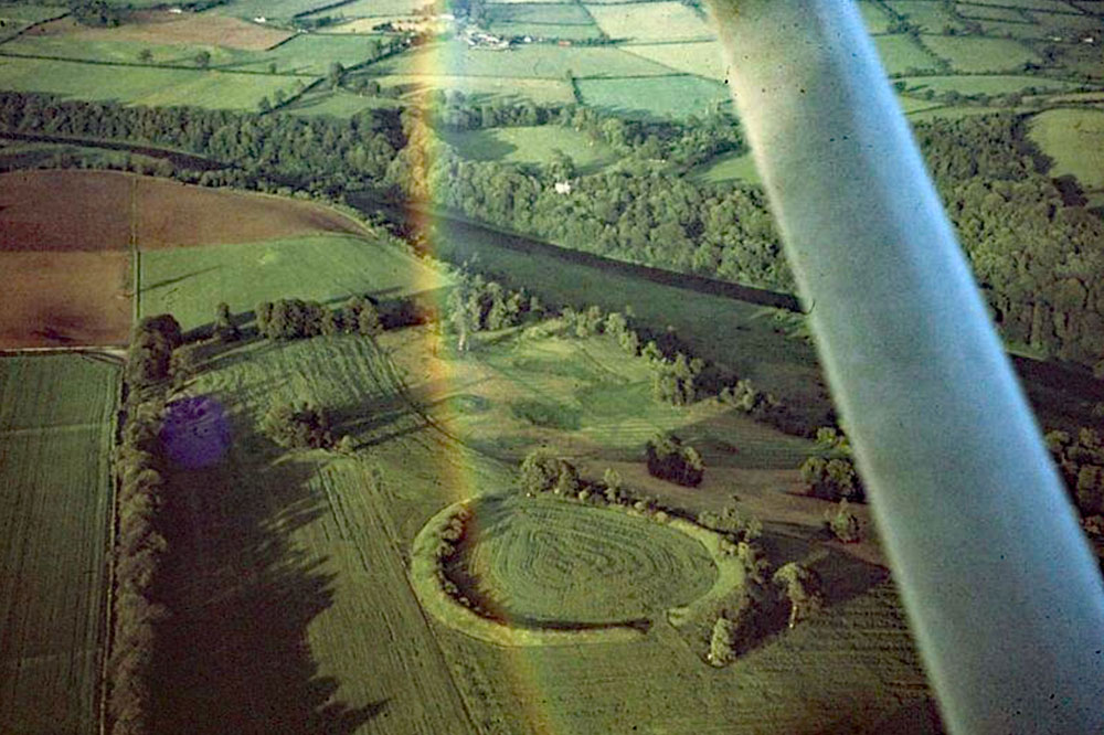
An aerial photograph of the huge henge monument located in the field to the east of Dowth Hall. Photograph by Dr. Daphne Pochin Mould. Source.
The monument may have been used as some kind of sporting arena, where like ancient contests or feats of strength took place. It has been suggested that some English henges were used for displays of rtual hunting at a time when the neolithic farmers were more prosperous, and large scale hunting and gathering was a distant memory. Displays of physical prowess, something like modern day bull fighting may also have taken place here. The massive bank is certainly ideal for spectators to sit and watch whatever action or drama was taking place within the enclosure.
Dowth Hall from an aerial photograph, showing the huge neolithic henge in the field beyond the mansion.
At Dowth Henge, multiple phases of geomagnetic survey have identified broad ditches both inside and outside the main enclosure (Davis Reference Davis2013; Fig. 9). These appear to show clear interruption at both entrances, suggesting that these are both original features. Some confusion has arisen because of the construction of an ornamental 18th century ‘tree ring’ blocking the north-eastern entrance, the removal of which has caused extensive disturbance. The geomagnetic data shows berms both inside and outside the henge bank. For most of the perimeter the internal and external berms are comparatively narrow (c. 5 m); however, the external berm broadens to 12 m approaching the south-western entrance/egress. Within the henge enclosure, in addition to at least one roughly circular central pit or post arrangement, a pair of large pits or post-holes spaced 4.5 m apart is located directly in line with the south-west entrance. Also central within Dowth Henge is a complex collection of elongated pits which may represent the footings of a demolished passage tomb similar to that centrally located within the Giant’s Ring at Ballynahatty, Co. Down.
The world's most famous henge, Stonehenge, is actually not a henge at all, but a complex stone circle.
National Monuments Service Report
This monument is described by Stout (1991, 259) as: This impressive enclosure is situated towards the summit at the eastern end of a ridge above the River Boyne. It is located on a grey-brown podzolic soil. The passage tombs at Dowth are situated 1 kilometer to the south-west.
The monument consists of a flat-topped earthen bank which encloses an oval area, 165 meters north-west – south-east by 175 meters north-east to south-west. The bank is well preserved, reaching heights of between 3 meters and 5 meters. It is 20 meters wide on average. The interior has a domed shape created by the scarping of an area 18 meters wide inside the inner edge of the bank. This was the source of the bank material.
New henge discoveries at Newgrange in the Boyne Valley - 10th July 2018.
The enclosing bank is breached in two diametrically opposed places; the more definite of the two breaks occurs in the south-west (227 degrees T) for a maximum distance of 20 meters, narrowing to 12 meters. The second opening, in the north-east (55 degrees T), was marked by a dotted line on the Ordnance Survey first edition map. Today the bank at either end of this break narrows considerably and there are traces of a narrower bank continuing across part of the break, leaving a gap of 15 meters. A slight rise and a definite fall to the exterior along this opening in line with the bank make it highly probable that this opening is not contemporary with the construction of the enclosure. A shallow ditch outside the bank in the south-west portion of the enclosure corresponds to a field fence marked on the OS 6-inch map of 1837.
Geophysics have identified the remains of structures within the Dowth henge, but the monument has never been excavated.
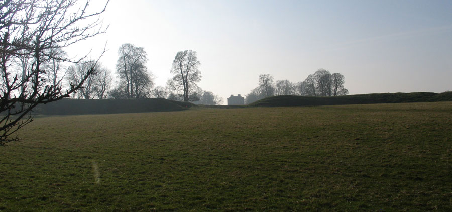
Looking south west through the gap in the huge henge to Dowth Hall. In 2017 a 40 meter passage-grave was discovered under Dowth Hall, a building constructed in 1760. The passage-grave was excavated in 2018 and several highly decorated examples of neolithic art were discovered. This photograph shows the relationship between the henge and the destroyed passage-grave.