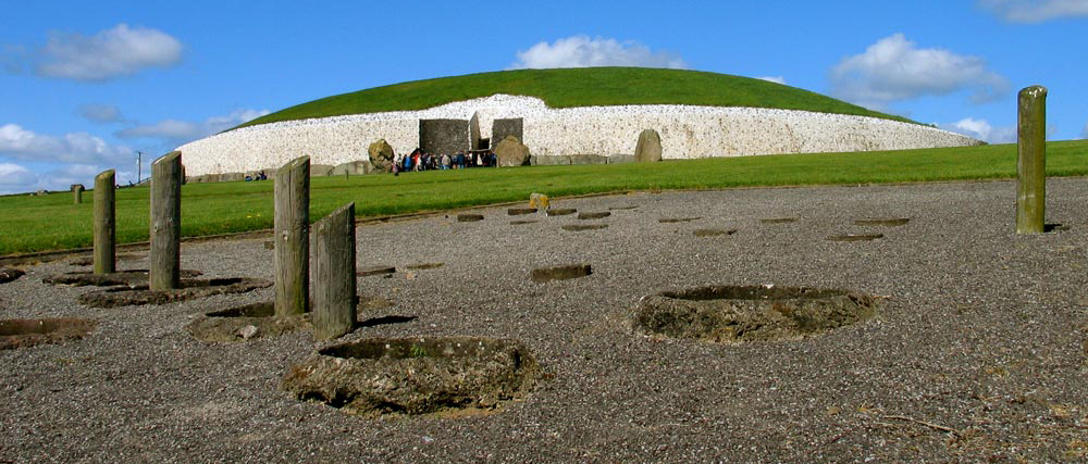
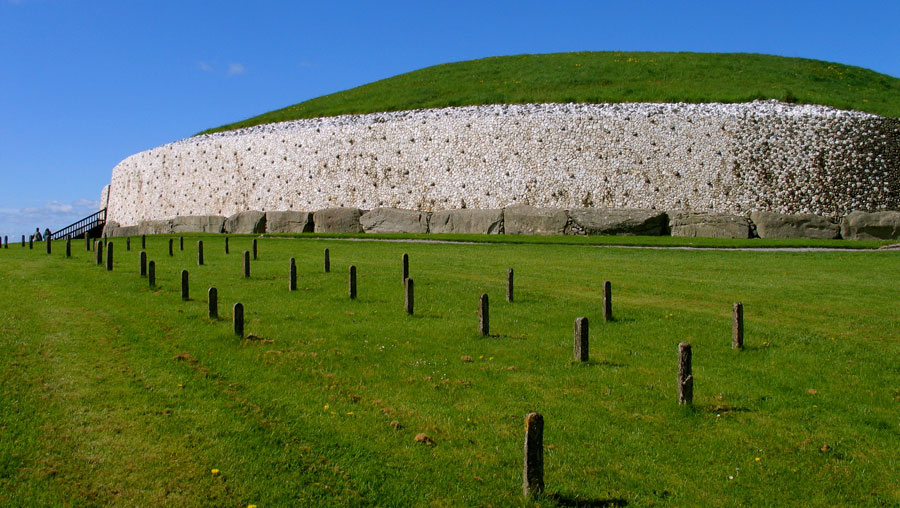
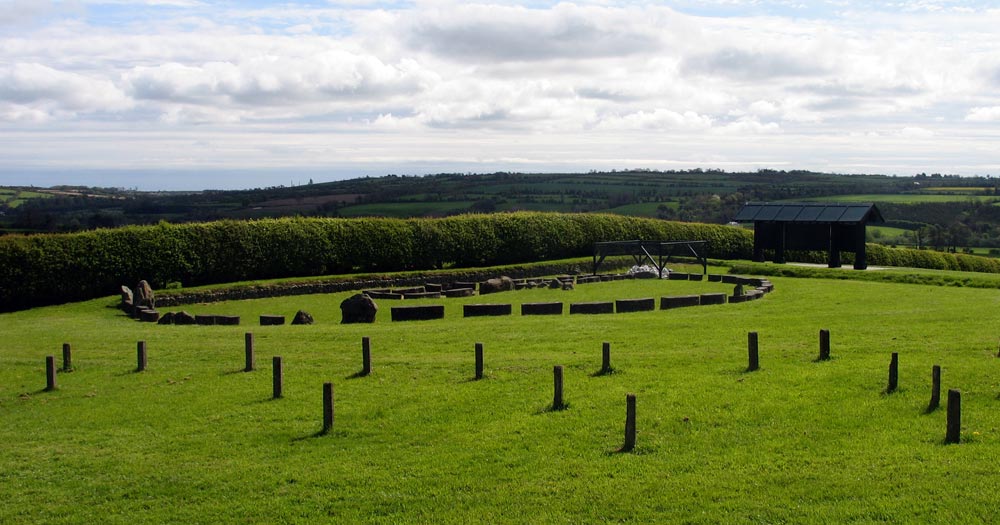
The huge bronze age henge at Newgrange. The site of the pits which held timber posts are marked by concrete pits, pieces of timber, and concrete pillars. The woodhenge is thought to have been built about 1000 years after the huge neolithic cairn, and is about 100 meters in diameter.
The Newgrange Pit-circle.
This report describes the results of limited archaeological excavations which took
place on a previously unknown Late Neolithic/Early Bronze Age pit circle situated
just south of the passage tomb at Newgrange. Excavation over two short seasons
in 1982 and 1983 revealed a series of pits and post-holes of varying sizes, construction
and function which formed an arc. Stake-holes found inside the line of this arc were
associated with Beaker pottery and flint-knapping.
During his investigation of the
Beaker and Late Neolithic settlement around the southern perimeter of the passage
tomb from 1962 to 1975, the late Professor M. J. O'Kelly discovered an arc of great
pits. It would appear from the present excavations that O'Kelly's pits and the
recently discovered ones are part of a large circular enclosure. Three Carbon 14 dates
obtained by O'Kelly from his pits centred around 2000 b.c. as did nine samples taken
by the writer from the recent excavation. The evidence also indicates that the great
stone circle is later than the circle of pits and is therefore associated with the Beaker
settlement and not contemporary with the tomb as suggested by O'Kelly.
There are many more ancient monuments to be found on the ridge of Newgrange besides the great passage-grave itself, including at least three or possibly four satellite passage-graves, a cursus, and a pair of pit-circles. Several new features were discovered on the flood-plain below Newgrange over the summer of 2018 when the unusually dry conditions revealed a series of cropmarks indicating the sites of monuments. A second cursus was excavated by Geraldine and Matthew Stout on the grounds of Newgrange Farm a short distance south of the monument.
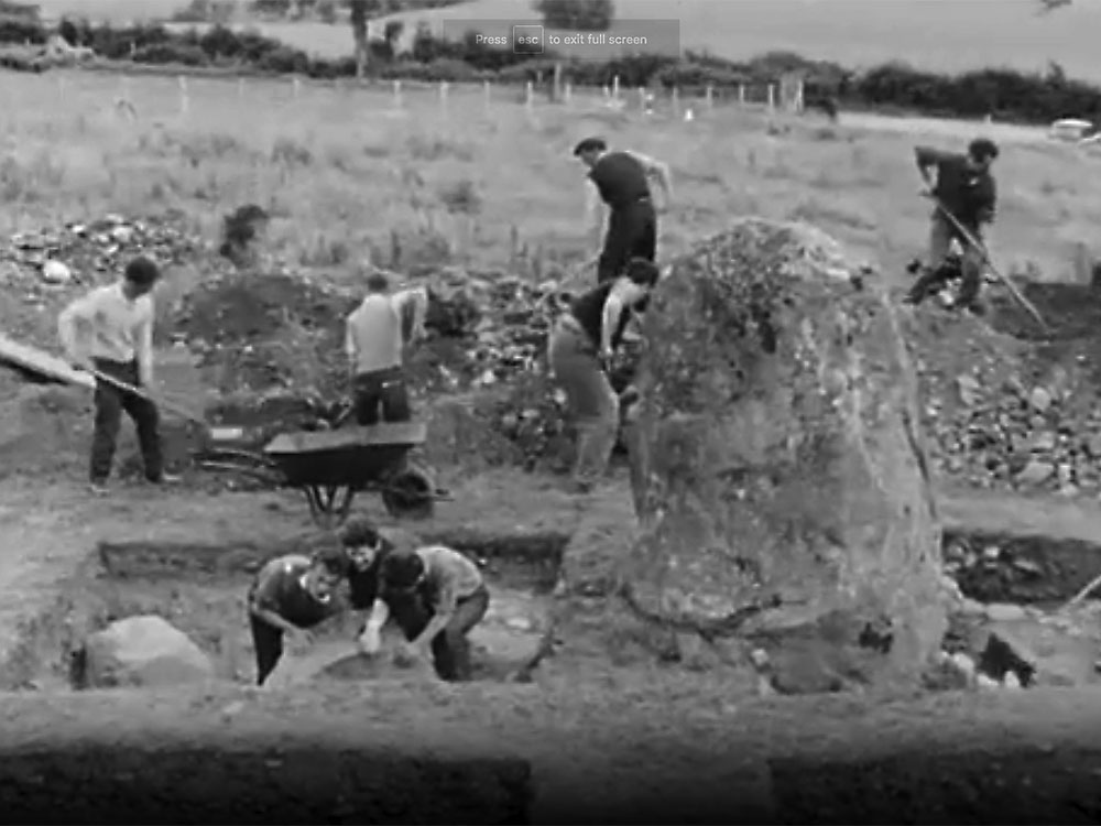
Excavations at the front of Newgrange during the first season of digging in 1962. O'Kelly's search for possible sockets of stones missing from the Great Circle led to the discovery of the huge Newgrange pit-circle.
During Professor Michael O'Kelly's exacvation of the Great Circle, a series of pits were discovered nine meters out from the kerbstones on the east side of Newgrange. The series of pits and post holes semed to run beneath the Great Circle, which seemed to indicate that the pits were older than the circle. O'Kelly recovered three Carbon 14 dates from samples taken from several pits, all of which were dated to the bronze age. Michael O'Kelly seems to have been much more interested in the neolithic aspects of Newgrange, and underplayed the extent of bronze age activity in his book Newgrange, Archaeology, Art and Legend, which was published in 1982.
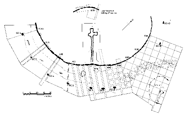
Plan of the excavation from the book Newgrange by Michael O'Kelly. The woodhenge pits and satellite monument Site Z are to the right.
In 1982, the year O'Kelly's book was published, archaeologist David Sweetman led the excavation of an area slated for the location of a new Office of Public Works guide hut. As Sweetman began excavating in the south east portion of the Newgrange field, close to the standing stone known as the Dowth Stone, he discovered an arc of pits which seemed similar to those discovered by O'Kelly twenty years earlier. Sweetman suspected they were likely to be part of the same monument, and five test trenches proved that this was indeed the case.
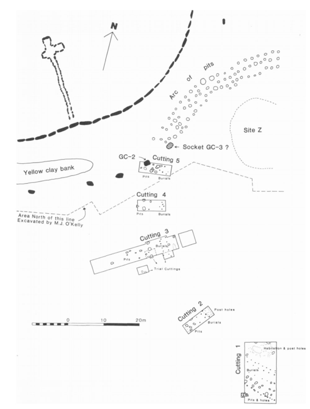
Plan of the excavation of the Newgrange Pit-circle from David Sweetman's report.
The Newgrange pit-circle is approximately 100 meters in diameter, about the same size as the massive but incomplete circle of standing stones surrounding Newgrange. The Pit-circle consists of four to six rows of pits and post holes, the outer ring of which probably held large timber uprights. Some of the pits appear to have resulted from ritual feasting, as many burnt and charred animal bomes were found. The larger pits were found on the outer rim of the structure, some were up to a meter wide and deep. The outer pits were found to have been dug to contain timber uprights. Some of the inner pits had been lined with a thick putty-like layer of soil - up to 25 centimeters thick in some cases.
Inside the arc of large post-holes there were two lines of pits which
could be divided into two types based on their make-up. One type consisted of a
large pit, up to 1 meter in diameter and lm deep, dug into boulder clay and lined with
a putty-like sterile clay. The filling of these pits consisted of charcoal, burnt clay
and redeposited boulder clay. The outer arc of large pits were all of this type. The
other type was not clay-lined and sometimes contained a post-hole as if deliberatelydug to hold a wooden post. However, the size ofthe pits was disproportionately large for this purpose. The inner row of pits had a mixture ofthe two types,
some being clay-lined, some unlined, and others containing post-holes.
Plan of the excavation of Cutting 1 which demonstrated that the circle was part of the collection of pits found 20 years earlier beside Newgrange, image from from David Sweetman's report.During Michael J. O'Kelly's programme of conservation at Newgrange, concrete pillars mark the locations of each pit within the circle. This photo shows how close the pit-circle comes to the kerbstones around the base of the cairn.
The Second Pit-circle at Newgrange
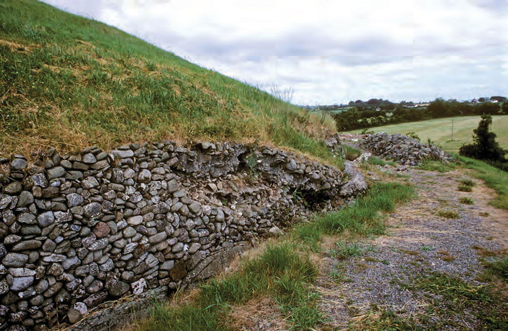
Over a number of years, since the conservation works were carried out by the
Office of Public Works on the south side of the passage tomb at Newgrange, there
have been ominous signs of collapse at the northern side of the mound as a result
of settlement pressure. In spring 1984 the National Parks and Monuments Branch
of the Office of Public Works commenced work at the north side of the tomb,
under the supervision of the writer, to stabilise the mound, which had collapsed in
limited areas between stones Kerbstone 52 and Kerbstone 67.
When this work
was near completion it was found to be necessary to lay a temporary road surface
along the western boundary of the National Monument area to give cement trucks
access to the north side of the mound. A trackway had already been constructed
in 1983 from the present roadway along the western margin to close to the brow of
the ridge on which the passage tomb is sited. When the sod was lifted from a ten
metre-wide strip at the top of the ridge, 50 meters due west from the passage tomb, there
was clear evidence of charcoal and burnt soil. It was then decided that this limited
area should be archaeologically investigated and work commenced in
June 1984.
In 1984 a second smaller circle of pits and or post holes was found on the west side of Newgrange. This second circle is some twenty meters in diameter - about the same size as the restored example at Knowth - one kilometer to the west of Newgrange. As Sweetman mentions in the quote above, the discovery came about because the back of Newgrange had collapsed. The massive reinforced concrete revetment which was installed at the front of the monument had caused a build-up of water which had no way of running off, which caused the rear portion of Newgrange to bulge and burst, requiring repair work between Kerbstone 52 and Kerbstone 67.
The back of Newgrange showing the collapsed 1880's mortared revetment caused by a back-up of water caused by the reinforced concrete additions to the front of the monument. The image is taken from Newgrange revisited: new insights from excavations at the back of the mound in 1984–8 by Ann Lynch.
In order to allow cement lorries to drive up to the rear of the monument, an access road was installed on the west side of the cairn, along and in front of some existing Office of Public Works buildings. The excavation of a ten meter wide trench uncovered evidence of lots of burning and a number of pits.
This report describes the limited excavations that took place over four weeks
on a Late Neolithic/Early Bronze Age site about 50 meters to the west of the passage tomb
of Newgrange. The excavation revealed two main rows, roughly parallel, of pits
and post-holes which formed an arc and are probably part of a circle about 20 meters in
diameter. The site appears to have had two distinct phases, the earlier associated
with the larger pits and the later with the post-holes. Beaker pottery and a rim
sherd of a decorated stone bowl were recovered from the pits. Two 14C samples
indicate a date about 2000 b.c.
The smaller Newgrange pit-circle is composed of a set of pits and holes which Sweetman divided up into five categories. The five largest pits had first been used as fire pits before being back-filled and used as postholes for substantial timber posts. The excavators at first did not appreciate how big some of these original firepits had been because they had been backfilled during reuse. Some of the timber posts may have been burned down while standing, possibly destroyed during a ritual or accidental event. Thick layers of charcoal were found in some of these pits, along with fragments of Beaker pottery, flint and burnt animal bone.
The next group consists of ten pits which seem to have been originally used to dump refuse, although two of them showed evidence of reuse as post holes. A third group of five holes, which averaged 70 centimeters deep, were dug as postholes, as opposed to reused firepits or refuse pits as found in the first two groups. The fourth group consists of eleven postholes about 25 centimeters in diameter and 30 - 60 centimeters deep. The fifth group os a set of eight stake-holes, smaller than the other categories.
The Beaker Period
Structures such as the Newgrange Pit-circles is generally dated to the transition period between the neolithic and the bronze ages, younger than the passage-graves but older than the Great Stone circle. Charred bones of many animals but largely pig from the Beaker Period were found by Sweetman in many of the holes and pits. The largely destroyed neolithic passage-grave Site Z is located within the larger Pit-circle, and possibly another site, Z1. About 100 meters to the east of the Pit-circle is the terminal of the Newgrange cursus, a ceremonial causeway or walkway that has not yet been dated. A second cursus was discovered a few years ago on the grounds of Newgrange Farm to the south, and this has been excavated by Geraldine and Matthew Stout.
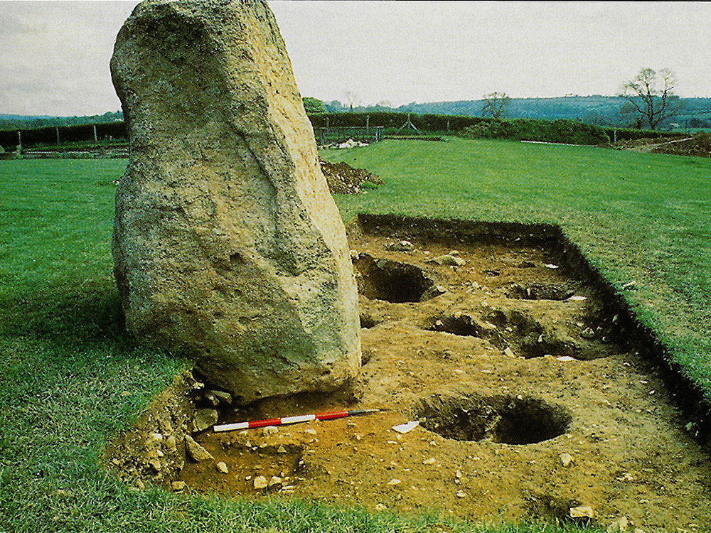
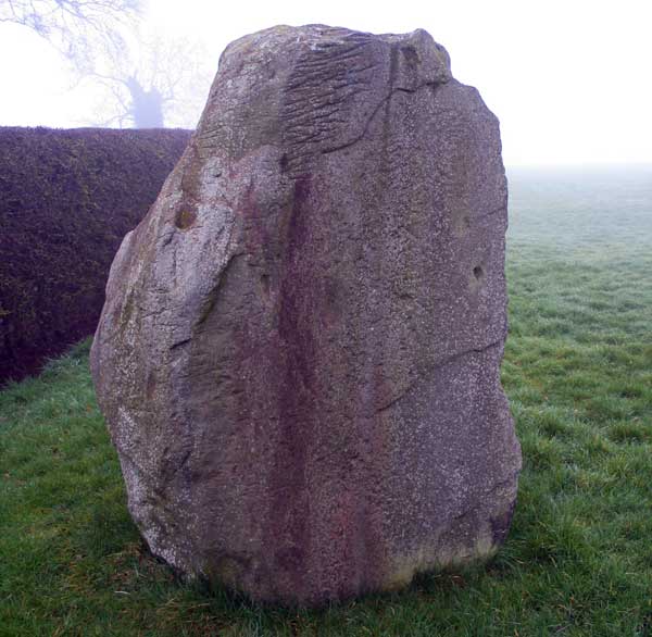
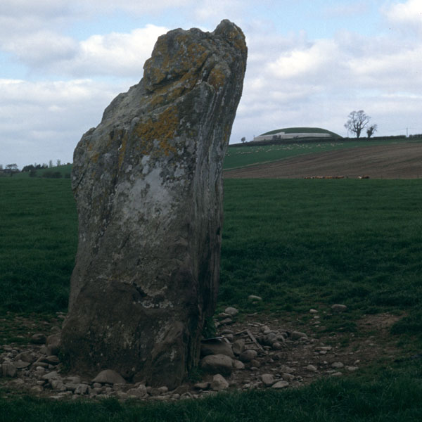
The Dowth Stone, found at one of the satellite monuments between Newgrange and Dowth, and re-erected near Newgrange by Michael J. O'Kelly in 1967.
There are a number of henges in the Boyne Valley dating to the late neolithic. One of the largest henges in the country, Site Q, is one kilometer east of Dowth. They are thought to belong to a time when many people were coming to visit the Boyne Valley in large numbers, possibly neolithic pilgrims visiting in much the same way as happens at places like Newgrange today.
Strangely enough, Michael J. O'Kelly represents the bronze age Beaker people who used Newgrange after the neolithic as 'squatters' in his book Newgrange, Archaeology, Art and Legend.
Given the repeated references to the Beaker occupation in this volume, it is unfortunate that the decision was made to discuss that evidence fully elsewhere. More seriously, this evidence of occupation on the site after the original facade had collapsed and the mound material had begun to slump across the area outside the kerb is consistently called that of 'Beaker squatters.' I believe this terminology presupposes an interpretation that is not necessarily supported by the evidence. 'Squamers'implies not only that the monument had fallen into disuse but also that during this period the original purpose and use of this monument had been lost. I don't believe we can safely make this assumption.
There seems no reason to believe the Beaker inhabitants were not descendants ofthe builders of the monument and thus well aware of its role. For whatever reason, the people of the region had given up building pasmge gnaves (though the small Mound of the Hostages at Tara a few miles south, seems to date to about this
period). But after all, how many cathederals does a community need to build? It seems quite clear tha tNewgrange continued to be revered and considered the abode of the gods right down into the Early Christian perid.
Newgrange: Archaeolory, Art and Legend by Micltnel J. O'Kelly, contributions Uy Clare O'Kelly,
Reviewed by Ronald Hicks.
The large standing stone labelled Site C, looking northeast up the ridge to Newgrange. The large timber circle would have been visible from this position, and the stone may have been a position from which to observe minute changes in the rising positions of the sun and moon against the timber posts of the pit circle.
The timber henge may have an astronomical purpose. A viewer standing on Site B or Site C on the flood plain below could watch midsummer sunrises and midwinter moonrises appearing between Sites K and L, Newgrange, and extreme moonsets through the timbers of the henge. A concern for studying the movements of the heavenly bodies in this region of the sky can be found at the older complexes of Carrowmore and Carrowkeel in County Sligo. The early roofbox above the entrance to the chamber of Cairn G is focused on the area of the horizon where the paths of the sun and moon cross at their nodes. This focus of interest may well be an attempt to moniter and predict solar and lunar eclipses.
Looking from Newgrange to Site Z. Each of the concrete pillars marks the site of a wooden pillar from the massive neolithic timber henge.